

Outdoor Recreation in the Time of COVID-19
Land Trusts are encouraging people to get outside and enjoy Rhode Island's outdoor spaces BUT TO DO SO SAFELY. Please read about How to Walk Outdoors Safely During COVID0-19.
If you get to a location and find it crowded we encourage you to use ExploreRI to find another place to walk.
Go Paddling:
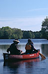
Information on fresh and saltwater kayaking and canoing in Rhode Island and the Narragansett Bay watershed, from the Blackstone to the Wood-Pawcatuck, to the Taunton River in Massachusetts! These are the best places to go kayaking and to launch a canoe or kayak for an adventure. Here are some ways to find your next paddling experience and paddle safely:
Go for a Walk:

Find a trail, go for a walk and explore. Information about Rhode Island's best walking and hiking trails. Whether you want to enjoy an easy walk nearby and relax outdoors in a park or experience an adventure on a more challenging day-long hike, there's a trail here for you!
The Water is Still COLD!
 Spring is here and summer is coming but please remember that the water warms up much more slowly than the air and so the water (especially in the ocean/bay but also in rivers, lakes and ponds) is still very cold. So, when heading out to go paddling please remember to wear clothing that will keep you warm even if you get wet (e.g, a wetsuit or drysuit or at a minimum wool or synthetics) and use extra caution, especially on the bay and on larger lakes and rivers, and always, always: Remember to wear your life jacket!
See Where You Are On a Map as You Walk with Avenza Maps
The Rhode Island Land Trust Council and ExploreRI have started to make selected trail maps available for free on the Avenza maps platform.
Avenza maps are special, free maps that you can use in the Avenza app on your smart phone. These maps let you see your location on the map as you walk. Download the Avenza App for free in the Apple App Store or on Google Play
Once you've got the app, click on the Avenza Trail Map button to "purchase" the free map for this trail from the Avenza map store. If this is your first time, Avenza will ask you to set up an account to check out. However, all Avenza trail maps listed on ExploreRI are free.
So far we have made maps for the following trails available on the Avenza system:
- Frenchtown Park, Laurel Wood, and Fry Family Preserve Trails
- Geddes Bowen Preserve
- George Washington Wildlife Management Area
- Gold Star - Atlantic White Cedar Swamp
- Knight Farm Conservation Area
- Mercy Woods
- Monastery
- Pulaski Recreation Area
- Rocky Hill Road Conservation Area
- Sakonnet Greenway Trail
- Veterans Memorial Park - Eastern Side

National Geographic Names Rhode Island’s Blueways a “Best Adventure Destination for 2012”
Read the write-up on the National Geographic website and get out and paddle Rhode Island's Blueways!

26 Paddling Trail Maps!
See the Water Trails page for 26 paddle trail maps for paddling routes across Rhode Island! There are trips for all skill levels, all across the state, on rivers and lakes and salt ponds, all! These maps were created in partnership with ten watershed organizations across the state, with funding from the Rhode Island Foundation.
You can also see the water trail routes on our mapping system, and then click on the routes to get the detailed water trail maps.
Hunting Season Reminder
![]() Remember, in Rhode Island all users of state management areas and other designated undeveloped state parks must wear at least 200 square inches (e.g., a hat or vest) of solid daylight fluorescent orange clothing from the third Saturday in October to the last day of February and from the last Thursday in April to the last day in May, except during shotgun deer season (generally in December) when all users must wear 500 square inches of solid daylight fluorescent orange clothing (e.g., a hat AND a vest). For more details contact RI DEM or the park or management area you plan to visit.
Remember, in Rhode Island all users of state management areas and other designated undeveloped state parks must wear at least 200 square inches (e.g., a hat or vest) of solid daylight fluorescent orange clothing from the third Saturday in October to the last day of February and from the last Thursday in April to the last day in May, except during shotgun deer season (generally in December) when all users must wear 500 square inches of solid daylight fluorescent orange clothing (e.g., a hat AND a vest). For more details contact RI DEM or the park or management area you plan to visit.
In Massachusetts non-hunters are not required to wear hunter orange, but it is highly recommended, especially during deer season (generally in December). You should also wear hunter orange (a cap or vest) in late October and November if you are on or near state lands that are stocked with pheasants or quail. Hunters ARE required to wear hunter orange during these seasons and should check the Massachusetts regulations to make sure they know the exact requirements. Hunting is not allowed on Sundays in Massachusetts.
Note: The above information is designed to provide non-hunters with a general overview of the requirements for wearing blaze orange during hunting season. There are numerous special regulations in the hunting laws so check the official state websites for the exact rules, requirements and dates when blaze orange is required or recommended. And remember, it never hurts to wear blaze orange so when in doubt wear your orange vest and hat! Here's a video that shows how effective blaze orange is at making you visible to hunters.
Location: Rhode Island! 41°40'N 71°35'W