


 Donigian Park
41° 49.352' N 71° 26.408' W See this location in: Google Maps Map Server Acme Maps
This is a site for launching hand-carried boats and it is also a portage. This typically means that to continue paddling down the river past this site you will have to portage your boat around a dam or other obstruction.
Description & Overview:

Donigian Park is a city park next to the Woonasquatucket River. There is a broad set of stairs leading down to the river just upstream from Valley St. The dam at this site is upstream from the stairs, so if you are paddling downstream you will not have to portage around the dam. Paddling downstream from here involves some quick-moving water and challenging paddling. A better plan for inexperienced paddlers is to start downtown and paddle up the river to Eagle Square (Atwells Ave.) and then turn around and go back down. The tide affects much of the river below this site so plan accordingly. In times of low river flow some sections can be too shallow to paddle at low tide.
This site provides access to the following water bodies in the Woonasquatucket River watershed: Woonasquatucket River.
Location:
Alternate Site Name: Lonigan Memorial Park
Town: Providence
Nearest Town Center: Providence
Driving Landmarks: The park is on the west side of Valley Street in Providence, 2/10 mile south of Atwells Ave. The canoe launch is in the SE corner of the park, near the bridge over the river.
Access & Waters:
Water 'Features' At Site: dam, whitewater, flatwater/slow moving river
Note: Because one boat launch can access, say, both a lake and a river or both the upstream and downstream portions of a river, not all paddling trips at a given site will necessarily encounter all of the features listed.
Type of Access: Boat launch for hand carried boats
ADA Accessible Boat Launch? no
Shoreline: The boat launch is a short set of steps that cut down through the stone walls that line the river in this area.
Float/Dock: no
Approximate Length of Carry between Car Access and Water: 75 feet
Portage Length: 700 feet
Hours of Operation: Sunrise to Sunset
Parking:
Parking: on street, no overnight parking
ADA Accessible Parking Spaces? no
Nearby Amenities:
Public Restrooms: There are restrooms at various stores at the Eagle Square shopping plaza, which is a 10 minute walk east on Valley St., as well as at nearby gas stations.
Town Center: Olneyville Square is a 10-15 minute walk west on Valley St.
Outfitter: None nearby
Accomodations: None within walking distance
Sources for More Information:
AMC River Guide: 4th Edition, page 145
Ecological, Cultural & Recreational Attractions:
A fish ladder is being constructed just upstream at Rising Sun Dam. Construction is currently underway (October 2007).
Photographs:
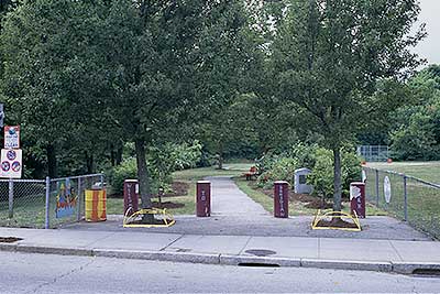
Entrance to Donigian Park
Photography by: Bruce G. Hooke
Date of Photograph: July 11, 2007
This is the entrance to Donigian Park from Valley St. The canoe launch is about 75 feet up the paved path, on the left.
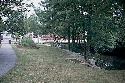
Donigian Park Canoe Launch Access
Photography by: Bruce G. Hooke
Date of Photograph: July 11, 2007
This is the grassy area at the head of the stairs leading to the river. Valley Street is in the background and the river is on the right.
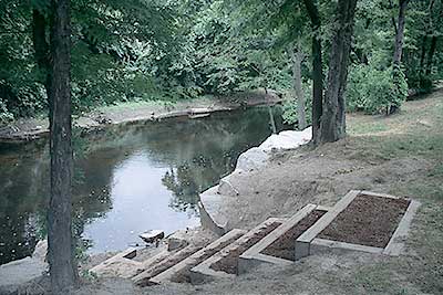
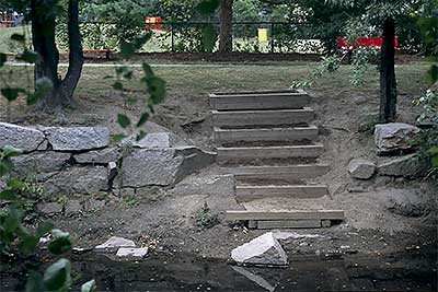
Donigian Park Canoe Launch Stairs
Photography by: Bruce G. Hooke
Date of Photograph: July 11, 2007
The stairs down to the river. This view is looking upstream towards the Rising Sun Dam.
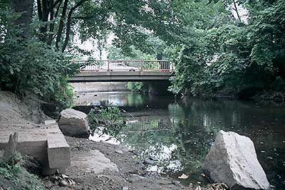
View Downstream from Launch
Photography by: Bruce G. Hooke
Date of Photograph: July 11, 2007
This is a view looking downstream from the canoe launch at Donigian Park. At this water level the river downstream from here would be very rocky until Eagle Square. This section of the river is best paddled when the river is higher.
Donigian Park Canoe Launch
Photography by: Bruce G. Hooke
Date of Photograph: July 11, 2007
View of the Donigian Park canoe launch from across the river. At this water level, the river between here and Eagle Square will be very rocky.
Do you have comments, corrections or additions to the information about this site?
Help us work together to make this website better by sharing your knowledge!

Private feedback goes to the Blueways Alliance/RI Land Trust Council. We'll use your information to make this website better or pass it along to the people who can deal with physical issues at this site. Public comments are posted here (once they've been reviewed and approved) for all to see.
The data on this website come from many sources, including volunteers and organizations across the state of Rhode Island and nearby parts of Massachusetts. We have done our best to make sure the data are accurate and up to date, but any information critical to the success of your trip should be confirmed before you start. The maps and information on this website should not be substituted for nautical charts, topographic maps, or other more detailed maps and guides. We welcome corrections and additions. To send a correction or provide other feedback, please use our feedback form (see link above).
This site report was last updated on January 15, 2009