

 Big River at Route 3
41° 38.663' N 71° 36.779' W See this location in: Google Maps Map Server Acme Maps
This is a site for launching hand-carried boats such as canoes or kayaks.
Description & Overview:

From this access site you can go either upstream or downstream. Big River is very slow moving so it is possible to paddle upstream, making round trips possible. Heading downstream from here takes you under Route 3 and then under I-95. Beyond I-95 is Reynolds Pond, a beautiful winding pond with big white pines on along the shore. For more on Reynolds Pond see the description for the Zeke's Bridge access site.
Heading upstream from Route 3 you are heading into the heart of the 8600 acre Big River Management Area. Be prepared for lots of twisting and turning because the river follows a very meandering course. At times the main channel can be hard to follow because of the many dead end side channels that branch off. If in doubt at a fork, look for which channel has more current. These challenges, combined with the fact that you are paddling upstream and likely to encounter beaver dams, makes this a much more energetic paddle than Reynolds Pond. The reward is getting to explore a beautiful natural area, but inexperienced paddlers may get frustrated before they get very far. Much of the area is low and marshy but the river occasionally swings close to higher ground, providing some possible picnic sites. If the water level is good and the channel not too overwhelmed by vegetation you can go about 2 3/4 miles beyond Route 3 to where Nooseneck River comes in from the west. Shortly beyond here both Nooseneck River and Big River get too narrow to be paddleable.
This site provides access to the following water bodies in the Pawtuxet River watershed: Big River.
Location:
Town: West Greenwich
Driving Landmarks: Take exit 6 off I-95 in West Greenwich. If you are coming from the north (Warwick), turn left at the end of the ramp; if you coming from the south (Westerly), turn right. This will put you on Route 3 (Nooseneck Hill Road) heading south. Go 0.6 miles and look for a dirt pullout on the left just after the bridge.
Access & Waters:
Water 'Features' At Site: flatwater/slow moving river
Note: Because one boat launch can access, say, both a lake and a river or both the upstream and downstream portions of a river, not all paddling trips at a given site will necessarily encounter all of the features listed.
Type of Access: Boat launch for hand carried boats
ADA Accessible Boat Launch? no
Shoreline: The trail is short but a bit rocky, but once past the rocks there is a nice sandy place from which to launch.
Float/Dock: no
Approximate Length of Carry between Car Access and Water: 50 feet
Parking:
Parking: yes: 8 spaces
ADA Accessible Parking Spaces? no
Sources for More Information:
AMC River Guide: 4th Edition, page 146
AMC Quiet Water Canoe Guide: 2nd Edition, page 190
Other Guidebooks: Paddle 19 in "Paddling Connecticut and Rhode Island"
Photographs:
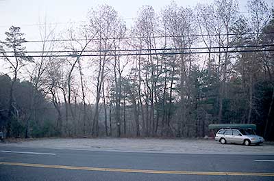
Parking area for the Big River at Route 3
Photography by: Bruce G. Hooke
Date of Photograph: April 20, 2008
An early morning view of the parking area on Route 3 near the bridge over the Big River
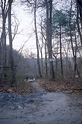
The Path from Route 3 to the Big River
Photography by: Bruce G. Hooke
Date of Photograph: April 20, 2008
The path from the parking area next to Route 3 down to the Big River. The white sign on the tree identifies the Big River as Trout Waters.
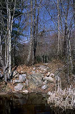
The Path to the River at Route 3
Photography by: Bruce G. Hooke
Date of Photograph: April 20, 2008
This is a view of the launching area on the Big River at Route 3 as seen from the water. What you can't see in this picture is that the water in the foreground is very shallow so once you have got your boat past the rocks there is a good space to stand and get into your boat.
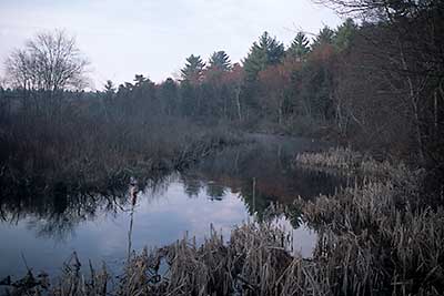
Early Morning View up the Big River
Photography by: Bruce G. Hooke
Date of Photograph: April 20, 2008
This is an early morning view up the Big River from the access site at Route 3. This photograph was made in the spring. Things would look greener in summer.
Do you have comments, corrections or additions to the information about this site?
Help us work together to make this website better by sharing your knowledge!

Private feedback goes to the Blueways Alliance/RI Land Trust Council. We'll use your information to make this website better or pass it along to the people who can deal with physical issues at this site. Public comments are posted here (once they've been reviewed and approved) for all to see.
The data on this website come from many sources, including volunteers and organizations across the state of Rhode Island and nearby parts of Massachusetts. We have done our best to make sure the data are accurate and up to date, but any information critical to the success of your trip should be confirmed before you start. The maps and information on this website should not be substituted for nautical charts, topographic maps, or other more detailed maps and guides. We welcome corrections and additions. To send a correction or provide other feedback, please use our feedback form (see link above).
This site report was last updated on January 15, 2010