

 Goddard State Park
41° 39.257' N 71° 26.651' W See this location in: Google Maps Map Server Acme Maps
This is a site for launching boats from trailers. Boat ramps can normally be used to launch canoes and kayaks but please do your best to keep the boat ramp clear for boat trailers.
Description & Overview:

Goddard State Park is a large state park with many amenities, including a boat ramp that was rebuilt in the fall of 2016 and which should now be in much better shape than it used to be. Goddard Park has much to offer, from beaches to walking trails to fishing, restrooms, and picnic areas. In the off-season it is also possible to launch hand-carried boats from the far east end of the swimming beach. Goddard State Park provides access to Greenwich Cove, Greenwich Bay and Narragansett Bay beyond. Greenwich Cove is very sheltered but can be busy. Greenwich Bay can be rough if the wind picks up and it can also be busy in the summer, but under most conditions this is a fine area for less experienced paddlers. On most days the southwest wind does fill in strongly in this area in the morning and blow throughout the afternoon, producing significant waves on Greenwich Bay, so be prepared for this when planning your trip.
This site provides access to the following water bodies: Greenwich Cove, Greenwich Bay, Narragansett Bay.
Location:
Town: Warwick
Nearest Town Center: East Greenwich
Driving Landmarks: From Route 4 take the exit for Route 401 (Division Street). Take a right at the end of the ramp (this applies no matter which way you were going on Route 4). Follow 401 into downtown East Greenwich and take a right at the stop light onto Main Street (Route 1). Go 1/2 mile south on Main Street then turn left onto Old Forge Road. Old Forge Road becomes Ives Road, which leads to the park. During the summer enter through the main entrance, which is at the far (east) end of the park (about 2 miles from Main Street) and then backtrack to the boat ramp, which is at the west end of the park. During the off-season you can enter at the west end through the white stone pillars (not the horse farm/farmers market entrance).
Access & Waters:
Water 'Features' At Site: estuary, ocean/bay
Note: Because one boat launch can access, say, both a lake and a river or both the upstream and downstream portions of a river, not all paddling trips at a given site will necessarily encounter all of the features listed.
Type of Access: Boat ramp
ADA Accessible Boat Launch? no
Shoreline: Concrete plank boat ramp and gravel beach
Float/Dock: no
Hours of Operation: Sunrise to sunset, year-round
Fees: Ther e is no fee for the boat ramp, but there are fees for some of the other park amenities
Parking:
Parking: yes: 50 spaces
ADA Accessible Parking Spaces? no
Nearby Amenities:
Public Restrooms: In season there are public restrooms not too far from the boat ramp.
Sources for More Information:
Other Guidebooks: Sites 14 and 15 in Ed Mullen's book "Kayaking Narragansett Bay"
Website: Goddard Memorial State Park website
Website: Mike Krabach's kayak access website
Ecological, Cultural & Recreational Attractions:
Goddard Memorial State Park is an almost 500 acre park on the south side of Greenwich Bay. It is one of the most popular state parks in Rhode Island and has many amenities, from a swimming beach to picnic areas, to walking trails, to a golf course.
Photographs:
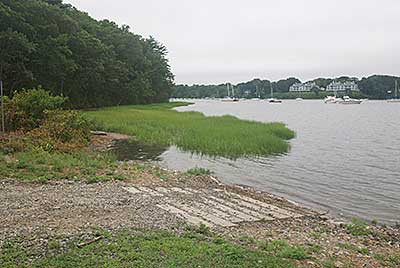
The Boat Ramp at Goddard State Park
Photography by: Tom Richardson, New England Boating
Date of Photograph: July 15, 2010
Do you have comments, corrections or additions to the information about this site?
Help us work together to make this website better by sharing your knowledge!

Private feedback goes to the Blueways Alliance/RI Land Trust Council. We'll use your information to make this website better or pass it along to the people who can deal with physical issues at this site. Public comments are posted here (once they've been reviewed and approved) for all to see.
The data on this website come from many sources, including volunteers and organizations across the state of Rhode Island and nearby parts of Massachusetts. We have done our best to make sure the data are accurate and up to date, but any information critical to the success of your trip should be confirmed before you start. The maps and information on this website should not be substituted for nautical charts, topographic maps, or other more detailed maps and guides. We welcome corrections and additions. To send a correction or provide other feedback, please use our feedback form (see link above).
This site report was last updated on November 7, 2016