

 Tiogue Lake - Arnold Road
41° 40.663' N 71° 33.383' W See this location in: Google Maps Map Server Acme Maps
This is a site for launching hand-carried boats such as canoes or kayaks.
Description & Overview:
This put-in is on a busy road but it provides plenty of roadside parking a short distance from the launch site, which is simply the natural shoreline of the lake at a small city park. There is a nice large area to load and unload boats. Tiogue Lake is a 226 acre reservoir with various bays and coves to explore but also a large open area 1/2 mile wide by almost a mile long. The shoreline is largely lined with houses. Tiogue Lake is stocked with trout several times during the spring.
This site provides access to the following water bodies in the Pawtuxet River watershed: Tiogue Lake.
Location:
Alternate Site Name: Korea - Vietnam Veteran's Memorial Park
Town: Coventry
Driving Landmarks: From I-95 north take Exit 7 for Coventry/West Warwick and go left at the end of the ramp. From I-95 south take Exit 7 for West Warwick and go right at the end of the ramp.
This will put you on New London Turnpike heading northeast. Go 0.3 miles and turn left onto Arnold Road. The put-in is 1.3 miles ahead on the right, across street from Cliff's Auto and Truck.
Access & Waters:
Water 'Features' At Site: lake/reservior
Note: Because one boat launch can access, say, both a lake and a river or both the upstream and downstream portions of a river, not all paddling trips at a given site will necessarily encounter all of the features listed.
Type of Access: Boat launch for hand carried boats
ADA Accessible Boat Launch? no
Shoreline: The ground slopes gradually from a concrete sidewalk down to the grassy and sometimes muddy water edge.
Float/Dock: no
Approximate Length of Carry between Car Access and Water: 50 feet
Hours of Operation: Sunrise to sunset, year-round
Parking:
Parking: on street, 15 spaces
ADA Accessible Parking Spaces? no
Nearby Amenities:
Public Restrooms: No
Ecological, Cultural & Recreational Attractions:
Veterans Memorial Park is a small park between Arnold Road and the lake. There are benches along the lakeshore.
Photographs:
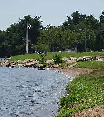
Tigoue Lake - Arnold Road Put-In
Photography by: Carolyn Richardson
Date of Photograph: July 30, 2006
The shoreline at the put-in.
Do you have comments, corrections or additions to the information about this site?
Help us work together to make this website better by sharing your knowledge!


Private feedback goes to the Blueways Alliance/RI Land Trust Council. We'll use your information to make this website better or pass it along to the people who can deal with physical issues at this site. Public comments are posted here (once they've been reviewed and approved) for all to see.
The data on this website come from many sources, including volunteers and organizations across the state of Rhode Island and nearby parts of Massachusetts. We have done our best to make sure the data are accurate and up to date, but any information critical to the success of your trip should be confirmed before you start. The maps and information on this website should not be substituted for nautical charts, topographic maps, or other more detailed maps and guides. We welcome corrections and additions. To send a correction or provide other feedback, please use our feedback form (see link above).
This site report was last updated on January 20, 2009
Comments:
Early morning at Lake Tioque 12/12/2020
Submitted by: Arthur iannelli; January 7, 2022; 8:33 pm
Rating:
Photographs:
Photo Credit: Arthur iannelli
History
Submitted by: David Schwartz; November 25, 2021; 8:55 pm
When and how was Lake Tiogue created?