

 Old Bridge Street
41° 52.3' N 70° 54.882' W See this location in: Google Maps Map Server Acme Maps
This is a site for launching boats from trailers. Boat ramps can normally be used to launch canoes and kayaks but please do your best to keep the boat ramp clear for boat trailers.
Description & Overview:

This site provides excellent access to the Nemasket River for canoes and kayaks and is also used to launch smaller trailered boats. Once you have unloaded your boat please make sure to park your car in a place that leaves good access to the shoreline for trailered boats.
The put-in is just above the Old Bridge Street bridge. With some effort you could paddle upriver under (new) Bridge Street and into the open wetland below Vaughan Street but that area is better accessed from Vaughan Street. Most paddlers putting in at Old Bridge Street will paddle downriver (under the Old Bridge Street bridge) from here.
Below the Old Bridge Street bridge the river winds its way slowly through wetlands. At normal river levels the current is barely visible in most areas but would be enough to make it hard work to paddle upriver. The wetlands below Old Bridge Street are not as extensive as the wetlands below Vaughan Street but are still quite pretty. In 0.8 miles you will go under Interstate 495. The tunnel that takes the river under the highway is almost 150 feet long but is big and open. Below the highway the river continues to wind through wetlands for another 0.4 miles to East Grove Street. In an emergency you could take out at East Grove Street but the busy road and lack of parking mean this is not a recommended put-in or take-out. Instead continue for another 0.7 miles and just before the Wareham Street Bridge look for a channel leading off to the right to a take-out next to the head of the fish ladder and the Middleborough DPW building. Do not go under the bridge! If you want to continue downriver from here you need to portage across Wareham Street into the park on the other side of the street and put-in below the dam and fish ladder. The river below here includes quickwater and a little whitewater. For more details see the description for Wareham Street/Thomas Memorial Park.
Click here for a printable map and guide (in Adobe Acrobat format) to paddling this part of the Nemasket River.
This site provides access to the following water bodies in the Taunton River watershed: Nemasket River.
Location:
Alternate Site Name: Stephen D. Kelley Conservation Area
Town: Lakeville
Nearest Town Center: Middleborough
Driving Landmarks: From I-495 north or south take the Exit 4 for Route 105, Middleboro Center and Lakeville. If you are coming from the north go right at the end of the ramp. If you are coming from the south go left at the end of the ramp. This will put you on South Main Street (Route 105) heading southwest. Go about 1/2 mile and turn left on Bridge Street. Go 1/2 mile on Bridge Street and then turn left onto Old Bridge Street, which ends (for driving purposes) in 1/4 mile at a dirt parking lot next to the river.
Access & Waters:
Water 'Features' At Site: flatwater/slow moving river
Note: Because one boat launch can access, say, both a lake and a river or both the upstream and downstream portions of a river, not all paddling trips at a given site will necessarily encounter all of the features listed.
Type of Access: Boat ramp
ADA Accessible Boat Launch? no
Shoreline: Sand and gravel shoreline excellent for launching hand-carried boats and usable as a boat ramp
Float/Dock: no
Parking:
Parking: yes: 12 spaces
ADA Accessible Parking Spaces? no
Nearby Amenities:
Public Restrooms: No
Sources for More Information:
AMC River Guide: 4th Edition, page 157
Website: Map and Guide to paddling the upper Nemsket River (Adobe Acrobat format)
Ecological, Cultural & Recreational Attractions:
This put-in/take-out is in the Stephen D. Kelley Conservation Area, owned by the town of Lakeville.
Photographs:
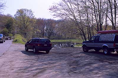
View of Parking Area at Old Bridge Street
Photography by: Bruce G. Hooke
Date of Photograph: May 1, 2010
The parking area at Old Bridge Street with the river beyond. The boat ramp is in the center of the picture, where the river is visible between the vehicles.
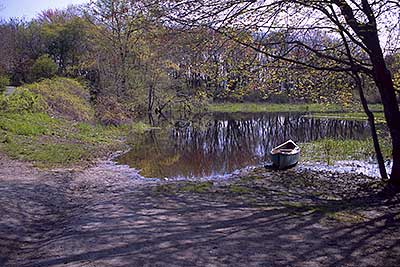
The 'Boat Ramp' at Old Bridge Street
Photography by: Bruce G. Hooke
Date of Photograph: May 1, 2010
The landing at Old Bridge Street. Downriver is to the left. The mound of green growth on the left in the picture is vines covering the Old Bridge Street bridge across the river.
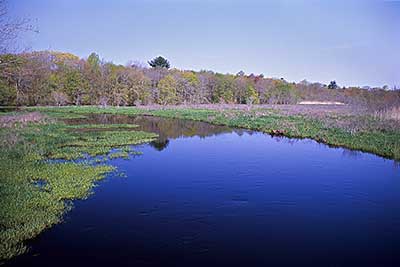
View Downriver from Old Bridge Street
Photography by: Bruce G. Hooke
Date of Photograph: May 1, 2010
A view down the river from the bridge at Old Bridge Street, in spring when the river was high.
Do you have comments, corrections or additions to the information about this site?
Help us work together to make this website better by sharing your knowledge!

Private feedback goes to the Blueways Alliance/RI Land Trust Council. We'll use your information to make this website better or pass it along to the people who can deal with physical issues at this site. Public comments are posted here (once they've been reviewed and approved) for all to see.
The data on this website come from many sources, including volunteers and organizations across the state of Rhode Island and nearby parts of Massachusetts. We have done our best to make sure the data are accurate and up to date, but any information critical to the success of your trip should be confirmed before you start. The maps and information on this website should not be substituted for nautical charts, topographic maps, or other more detailed maps and guides. We welcome corrections and additions. To send a correction or provide other feedback, please use our feedback form (see link above).
This site report was last updated on February 10, 2011