


 Rice City Pond / Hartford Avenue
42° 5.85' N 71° 37.382' W See this location in: Google Maps Map Server Acme Maps
This is a site for launching hand-carried boats and it is also a portage. This typically means that to continue paddling down the river past this site you will have to portage your boat around a dam or other obstruction.
Description & Overview:

There are many options at this site:
1. If coming down river from Plummer's Landing you can take out here (make sure you go under the river right stone arch bridge to reach the take out) and end your trip, or you can portage to either the river or the canal and continue down river. If taking out here, it is about 100 feet from the river to the usual parking locations.
2. You can also put in here and paddle "up river" under the stone arch bridge into Rice City Pond. Rice City Pond is marshy and has many side channels, and abundant wildlife including many migrating birds (in season). There is little current in the pond so it is a good place for poking around and exploring. When returning to the take-out make sure to go under the rightmost stone arch as the other arches lead to a waterfall over the dam.
3. If you want to go down river from Rice City Pond you can choose either the river or the old canal. The canal is filled with water and has essentially no current. You can paddle up to 1-1/4 miles down the canal and then turn around and paddle back. About 1/4 mile down the canal it opens up into a pond at River Bend Farm, which is the visitor center for the Blackstone River and Canal Heritage State Park. This is actually a better place to put in for paddling on the canal since it is a very short carry from the car to the water and there is a low dock to make it easy to get into your boat. Also, there is plenty of parking at River Bend Farm.
4. Lastly, you can put into the river and paddle down river. To get to the river below Rice City Pond carry down the hill into Ballou Park, go past the take out for Rice City Pond, go up past the end of the canal, and look for a path leading down to the river, where you can launch your boat. The river below here is a mix of flatwater and quickwater, with a short class I whitewater drop just before the take out at Route 16. There are numerous tight bends in the river and many strainers (trees down in the river) so especially if the river is at all high, this can be a challenging paddle!
5. If you want to avoid a car shuttle (and the Class I whitewater) you can paddle down the river for 1 1/2 miles and then pull into the marked side channel on river right where you can portage into the canal and paddle back up to the starting point. This route does NOT miss the tight bends and strainers.
Whichever place you paddle -- on the river, in the canal or in the pond -- houses and other buildings are only rarely visible from the river. For the most part you will be paddling between wooded banks or expansive marshlands.
The map and guide created by the Blackstone Valley Heritage Corridor is highly recommended for paddling this section of the Blackstone River. It can be downloaded from the park website at the link below.
NOTE: There are ongoing issues with pollution in the Blackstone River. Great strides have been made in cleaning up the river relative to where it was a generation or two ago but under some conditions the water may still have a noticeable odor.
This site provides access to the following water bodies in the Blackstone River watershed: Blackstone River, Blackstone Canal.
Location:
Alternate Site Name: Charles Ballou Memorial Recreation Area
Town: Uxbridge
Nearest Town Center: Uxbridge, MA
Driving Landmarks: From Route 122 go east on "Hartford Avenue East" for 1.1 miles. Look for Charles Ballou Memorial Recreation Area on the right, just before the river. Park in the gravel parking area along the road or pull into the parking lot for UMass Memorial and pull around to the part of the parking lot closest to the river, where there are park signs and an entrance to the park. If both of these parking areas are full there is also a large field across the street that can be used for parking.
Access & Waters:
Water 'Features' At Site: dam, whitewater, flatwater/slow moving river, pond
Note: Because one boat launch can access, say, both a lake and a river or both the upstream and downstream portions of a river, not all paddling trips at a given site will necessarily encounter all of the features listed.
Type of Access: Boat launch for hand carried boats
ADA Accessible Boat Launch? no
Shoreline: Sand and a little mud
Float/Dock: no
Approximate Length of Carry between Car Access and Water: 200 feet
Portage Length: 200 feet
Hours of Operation: May to August: 1/2 hour before sunrise to 8pm; Sept. to April: 1/2 hour before sunrise to 1/2 hour after sunset
Parking:
Parking: other, 50 spaces
ADA Accessible Parking Spaces? no
Sources for More Information:
AMC River Guide: 4th Edition, page 151-152
Ecological, Cultural & Recreational Attractions:
Charles Ballou Memorial Recreation Area has picnic tables, a walking trail along the canal, and views of the impressive dam system that creates Rice City Pond. The stone bridge that carries Hartford Avenue across the pond dates from 1869.
Photographs:
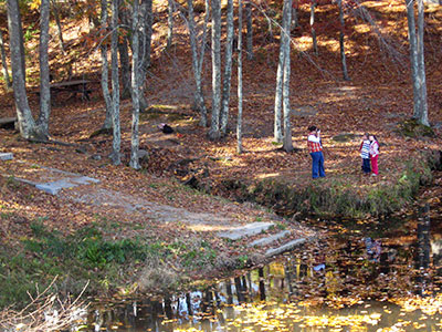
Take-Out Above the Dam
Photography by: Blackstone River Watershed Association
Date of Photograph: October 21, 2012
This is the put-in/take-out above the dam at Rive City Pond. To paddle up into the pond put in here and paddle up under the bridge.
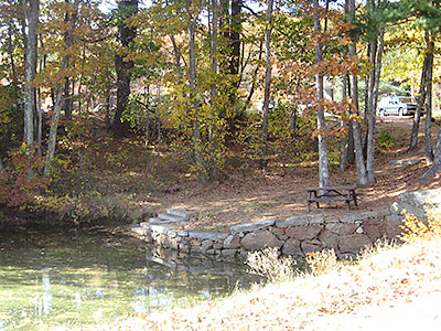
Put-In for the Canal
Photography by: Blackstone River Watershed Association
Date of Photograph: October 21, 2012
This is the put-in for the canal. The parking lot is in the background.
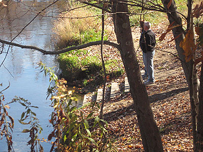
River Put-in Below the Dam
Photography by: Blackstone River Watershed Association
Date of Photograph: October 21, 2012
This is the put-in for paddling down the river below the dam. The parking lot and the take-out above the dam are both up the hill on the right in this photograph, beyond the end of the canal.
Do you have comments, corrections or additions to the information about this site?
Help us work together to make this website better by sharing your knowledge!

Private feedback goes to the Blueways Alliance/RI Land Trust Council. We'll use your information to make this website better or pass it along to the people who can deal with physical issues at this site. Public comments are posted here (once they've been reviewed and approved) for all to see.
The data on this website come from many sources, including volunteers and organizations across the state of Rhode Island and nearby parts of Massachusetts. We have done our best to make sure the data are accurate and up to date, but any information critical to the success of your trip should be confirmed before you start. The maps and information on this website should not be substituted for nautical charts, topographic maps, or other more detailed maps and guides. We welcome corrections and additions. To send a correction or provide other feedback, please use our feedback form (see link above).
This site report was last updated on September 21, 2020