

 Brownell Street Boat Ramp
41° 43.075' N 71° 9.451' W See this location in: Google Maps Map Server Acme Maps
This is a site for launching boats from trailers. Boat ramps can normally be used to launch canoes and kayaks but please do your best to keep the boat ramp clear for boat trailers.
Description & Overview:
This rebuilt boat ramp, with a float/dock alongside, provides access to the Taunton River in downtown Fall River. The Taunton River here is a 1/4 mile wide, busy commercial waterway that is open to the southwest and thus to the prevailing summer winds, which can kick up good-size waves. On most days the southwest wind develops in this area in the morning and blows through the afternoon, producing significant waves, so be prepared for this when planning your trip. Since there are docks and other commercial facilities along the shore, staying close the shore will not necessarily keep you clear of commercial traffic either. The north side of the river has fewer commercial facilities than the south (Fall River) side. Heading downriver (southwest) from the boat ramp it is a mile to the massive Charles Braga Bridge that carries I-195 over the river. Below this bridge the Taunton River opens out into Mount Hope Bay. Heading upriver (northeast) from the boat ramp the commercial facilities along the shoreline end after about 1.5 miles and from there it is another 7 miles to Dighton Rock State Park, where you can take out just before the small pier with rip-rap around it and a small white building on it, on the east side of the river. Motorboats are fairly common throughout this section of the Taunton. Above Dighton Rock State Park the river starts to narrow down and motorboats are less common, but the wind and tide continue to be an important factors in planning trips on this part of the river all the way up to Taunton. The river rises and falls with the tide for many miles above Taunton.
There are many rules related to the use of this ramp and adjacent areas on and off the water. Contact the harbormaster or see the signs at the ramp for more up-to-date information.
When launching or landing hand-carried boats at the Brownell Street Boat Ramp do your best to keep the ramp area clear for trailered boats. Practically, at least on busy days, this would likely be a rough place to launch or land a kayak or other hand-carried boat due to the heavy use by larger boats.
Note that there is a fee to use this boat ramp, even for hand-carried boats. See the Fall River Harbormaster's website for more details.
This site provides access to the following water bodies: Taunton River, Mount Hope Bay.
Location:
Alternate Site Name: Bicentennial Park
Town: Fall River
Nearest Town Center: Fall River
Driving Landmarks: From I-195 east or west take exit 5 for MA 79 and follow the signs onto 79 north. Go about a mile north on 79 and take the exit for N Davol Street. Follow N Davol Street parallel to the highway for 1/2 mile and turn left onto Brightman Street to cross over the 79. Immediately after crossing over route 79 turn left onto N Davol Street (yes, the same name is used for the streets on both sides of 79). Go 0.3 miles southwest on N Davol Street and turn right onto Brownell Street. The boat ramp is just ahead at the end of Brownell Street.
Note that all parking near the ramp is reserved for vehicles with trailers. It appears that it would be acceptable to park a vehicle without a trailer up in the lot beyond the tennis courts.
Access & Waters:
Water 'Features' At Site: estuary, ocean/bay
Note: Because one boat launch can access, say, both a lake and a river or both the upstream and downstream portions of a river, not all paddling trips at a given site will necessarily encounter all of the features listed.
Type of Access: Boat ramp
Shoreline: Concrete boat ramp and rip-rap shoreline.
Float/Dock: low float or dock
Fees: $5/day or $60/season for non-commercial use More Details
Parking:
Parking: yes: 46 spaces
Sources for More Information:
Website: Fall River Harbormaster's website
Photographs:
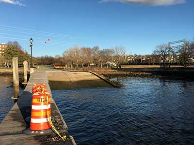
The Boat Ramp and Dock
Photography by: Bruce Hooke
Date of Photograph: April 7, 2022
The orange cones mark a burned area that should be repaired soon.
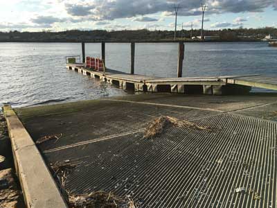
The Boat Ramp and Dock
Photography by: Bruce Hooke
Date of Photograph: April 7, 2022
Do you have comments, corrections or additions to the information about this site?
Help us work together to make this website better by sharing your knowledge!


Private feedback goes to the Blueways Alliance/RI Land Trust Council. We'll use your information to make this website better or pass it along to the people who can deal with physical issues at this site. Public comments are posted here (once they've been reviewed and approved) for all to see.
The data on this website come from many sources, including volunteers and organizations across the state of Rhode Island and nearby parts of Massachusetts. We have done our best to make sure the data are accurate and up to date, but any information critical to the success of your trip should be confirmed before you start. The maps and information on this website should not be substituted for nautical charts, topographic maps, or other more detailed maps and guides. We welcome corrections and additions. To send a correction or provide other feedback, please use our feedback form (see link above).
This site report was last updated on April 18, 2022
Comments:
Parking fee
Submitted by: Barry Farrow; June 4, 2017; 3:55 pm
Quick note there is a $5 fee to park in the lot,(free on street) well worth it i.m.o.,I came up from Warwick did not know till i got there,park workers,and harbor master were helpful and friendly with tips on current and boat traffic.
Rating: