

 Gano Park Boat Ramp
41° 49.323' N 71° 23.316' W See this location in: Google Maps Map Server Acme Maps
This is a site for launching boats from trailers. Boat ramps can normally be used to launch canoes and kayaks but please do your best to keep the boat ramp clear for boat trailers.
Description & Overview:

This boat ramp, opened in May 2014, provides access to the Seekonk River from the Providence side for both hand-carried and trailered boats. Most people launching here will probably be planning to head north up the Seekonk. At the boat ramp the Seekonk is over 1000 feet wide but still feels somewhat river-like. Further north the Seekonk is as much as half a mile wide and feels more like an estuary than a river. While the Seekonk is in the midst of urban northern Rhode Island it's a surprisingly wild-feeling place, with long stretches of wooded shoreline. At the far northern end of the Seekonk, 3½ miles from the boat ramp, the Seekonk narrows down and leads up to the mouth of the Blackstone River in Pawtucket.
Heading south from the ramp quickly takes you into the narrows between India Point and Bold Point and on into the Providence River, and the Port of Providence.
While the Seekonk is relatively sheltered wind and waves can still be an issue, especially in the broader parts of the "river." The tide is also an important issue, especially through the narrows south of the boat ramp, but also up past the boat ramp, where the river is still relatively narrow. Pay attention to the state of the tide when planning your trip and pay attention to the currents when on the water and be aware of how the currents will change as the state of the tide changes!
The boat ramp is concrete. Much of the nearby shoreline is rip-rap, but there is some sand and gravel where hand-carried boats could be launched away from the ramp, at least at lower tides. If you are launching a hand-carried boat, if possible please launch beside the ramp rather than on the ramp so trailered boats can use the ramp. If the conditions are such that you need to launch from the ramp, please do so expeditiously so you don't tie up the ramp for too long, if others are waiting to use it.
This put-in is on the Roger Williams Trail that traces the route Roger Williams and his followers took in 1636 when they paddled by canoe from what is now East Providence to Providence, to settle and found what would become the state of Rhode Island.
This site provides access to the following water bodies: Seekonk River.
Location:
Town: Providence
Nearest Town Center: Providence
Driving Landmarks: This ramp is right off Gano Street, across from East Transit Street, just north of I-195. Note that while the ramp is next to and part of Gano Park, the entrance to the boat ramp is three blocks (250 yards) south of the entrance to the rest of the park.
Access & Waters:
Water 'Features' At Site: estuary, ocean/bay
Note: Because one boat launch can access, say, both a lake and a river or both the upstream and downstream portions of a river, not all paddling trips at a given site will necessarily encounter all of the features listed.
Type of Access: Boat ramp
ADA Accessible Boat Launch? no
Shoreline: Concrete boat ramp and rip-rapped shoreline
Float/Dock: low float or dock
Parking:
Parking: yes: 17 spaces, no overnight parking
ADA Accessible Parking Spaces? yes
Nearby Amenities:
Public Restrooms: Restrooms may be available, at least in the summer, at Gano Park.
Ecological, Cultural & Recreational Attractions:
Gano Park is a small city park mostly devoted to playing areas for soccer, baseball and basketball. There's also a community garden.
Photographs:
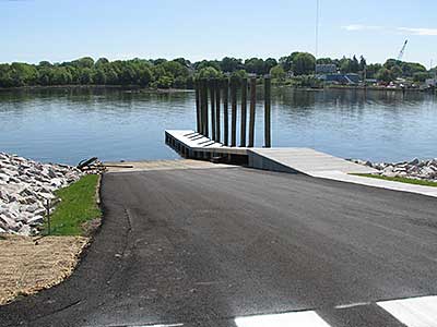
The Boat Ramp at Gano Park
Photography by: Bruce G. Hooke
Date of Photograph: May 21, 2014
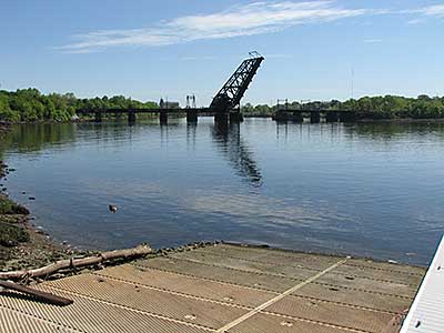
View up the Seekonk River from the Boat Ramp
Photography by: Bruce G. Hooke
Date of Photograph: May 21, 2014
The open bridge is a former railroad bridge that connected the rail line that's now the East Bay Bike Path to the rail lines running through downtown Providence.
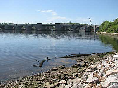
View Down Towards the Narrows Leading to the Providence River
Photography by: Bruce G. Hooke
Date of Photograph: May 21, 2014
The arch bridge carries I-195 across the Seekonk.
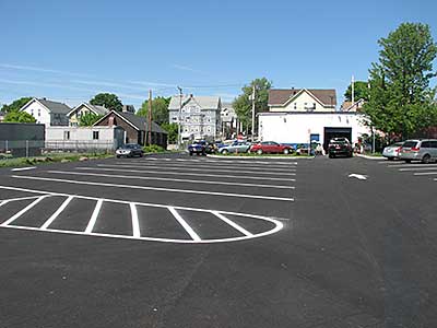
The Parking Lot for the Gano Park Boat Ramp
Photography by: Bruce G. Hooke
Date of Photograph: May 21, 2014
Do you have comments, corrections or additions to the information about this site?
Help us work together to make this website better by sharing your knowledge!

Private feedback goes to the Blueways Alliance/RI Land Trust Council. We'll use your information to make this website better or pass it along to the people who can deal with physical issues at this site. Public comments are posted here (once they've been reviewed and approved) for all to see.
The data on this website come from many sources, including volunteers and organizations across the state of Rhode Island and nearby parts of Massachusetts. We have done our best to make sure the data are accurate and up to date, but any information critical to the success of your trip should be confirmed before you start. The maps and information on this website should not be substituted for nautical charts, topographic maps, or other more detailed maps and guides. We welcome corrections and additions. To send a correction or provide other feedback, please use our feedback form (see link above).
This site report was last updated on August 10, 2022