

 Boyden Heights
East Providence, City of East Providence

![]() 1.0 miles of trail
1.0 miles of trail
Easy
Click on the "Trail Map (PDF)" button to download a PDF of the trail map that you can print and take with you on the trail.
Avenza maps are special, free maps that you can use in the Avenza app on your smart phone. These maps let you see your location on the map as you walk. Download the Avenza App for free in the Apple App Store or on Google Play
Click on the Avenza Trail Map button to "purchase" the free map for this trail from the Avenza map store. If this is your first time, Avenza will ask you to set up an account to check out. However, all Avenza trail maps listed on ExploreRI are free.
In Rhode Island the primary hunting seasons typically run from the second Saturday in September to the last day of February and from the third Saturday in April to the last day in May, however this can vary from year to year and depends on what game is being hunted. During hunting season you should wear at least 200 square inches (a hat OR a vest) of blaze orange. During shotgun deer season, which is typically in December, you should wear at least 500 square inches of blaze orange (a hat AND a vest). For more information see the RI DEM website.
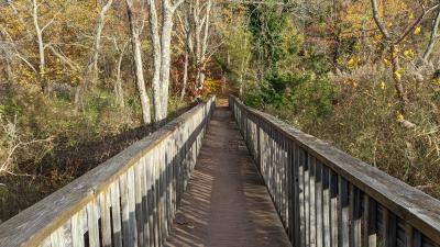
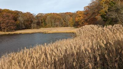
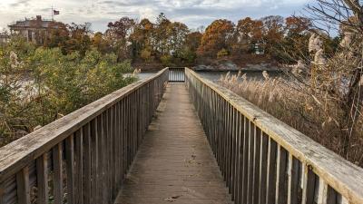


Boyden Heights is an East Providence Conservation Commission property that overlooks a cove and the Providence River. The trailhead starts at a small parking area on Boyden Boulevard. There is a red blazed loop trail, a blue blazed "lollipop" loop trail, as well as a spur that leads to the bike path. One of the highlights of Boyden Heights is the dock that reaches out into the cove. Swans, ducks, and several other species of birds, including orioles, yellow finches, and woodpeckers are commonly seen here. Across the cove, the clubhouse of the Squantum Association is the most predominant structure. It was built in 1900 replacing the 1873 structure. The property also abuts the East Bay Bike Path, if you wanted a walk of more distance you could follow the bike path south to the Pomham Rocks Lighthouse or to the north toward Watchemoket Cove.
Hiking blog featuring East Providence properties
Dogs: Yes. Dogs must be on leashes and owners must pick up waste.
Bicycles: No. However, you may walk your bicycle through the property to access the bike path from the neighborhood

Boyden Boulevard Trailhead
Driving Landmarks: Off of Pawtucket Avenue in East Providence near the intersection of Veterans Memorial Parkway. Follow Pawtucket Avenue south three blocks to Boyden Boulevard. Follow Boyden Boulevard to bottom of hill and trailhead will be on the right by a small parking area.
Parking: Yes: Parking lot, 3 spaces, no overnight parking
ADA Accessible Parking Spaces? No
Coordinates: 41° 47.372' N 71° 22.182' W See this location in: Google Maps Acme Maps
Accessible from the East Bay Bike Path, just south of the Squantum Club
KEY:
Trailhead
Only trailheads related to this trail system are shown on this map. To see all trailheads go to the main map.
Do you have comments, corrections or additions to the information about this site?
Help us work together to make this website better by sharing your knowledge!


Private feedback goes to the Blueways Alliance/RI Land Trust Council. We'll use your information to make this website better or pass it along to the people who can deal with physical issues at this site. Public comments are posted here (once they've been reviewed and approved) for all to see.
The data on this website come from many sources, including volunteers and organizations across the state of Rhode Island and nearby parts of Massachusetts. We have done our best to make sure the data are accurate and up to date, but any information critical to the success of your trip should be confirmed before you start. The maps and information on this website should not be substituted for topographic maps or other more detailed maps and guides. We welcome corrections and additions. To send a correction or provide other feedback, please use our feedback form (see link above).
This site report was last updated on May 13, 2021
Comments:
Nice scenery
Submitted by: Ken Magee ; November 6, 2022; 8:27 pm
Rating:
Photographs:
Photo Credit: Ken Magee
Photo Credit: Ken Magee
Photo Credit: Ken Magee