

 Chapman Pond
41° 22.892' N 71° 47.99' W See this location in: Google Maps Map Server Acme Maps
This is a site for launching boats from trailers. Boat ramps can normally be used to launch canoes and kayaks but please do your best to keep the boat ramp clear for boat trailers.
Description & Overview:
Chapman Pond is a 163 acre lake that is stocked and managed for Northern Pike. At the access site there is a gravel parking lot and a cement boat ramp. There is now also a cement pad to provide good ADA parking and a wheelchair accessible dock beside the boat ramp.
No motors over 10 H.P. may be launched or hauled from the ramp.
Chapman Pond is or used to be popular for fishing, but recently the invasive species have made it hard to fish and boat on here. The invasive species reported include: American lotus, spiny naiad, curly-leaf pondweed, water chestnut, and Eurasian watermilfoil. Please wash your boat, motor, trailer, and related gear carefully after boating in Chapman Pond to make sure you don't transport invasive species to other ponds.
The Town of Westerly recently installed a solar-powered free boat cleaning station at Chapman Pond so that all boaters (motorized and non-motorized) can remove all bits of aquatic plants from their boats, trailers, bilges, motors, etc., after you've removed your boat from Chapman Pond. It's CRUCIAL that all boaters remove all traces of plant matter BEFORE leaving the area, including emptying bait boxes, bilges, etc. so the invasive plants that plague Chapman Pond aren't spread elsewhere. Please use this free boat cleaning station to prevent the problems that have developed here spreading throughout the state. This solar boat cleaning station was funded in part by EPA, and RIDEM and by the Town of Westerly. Thank you to the anonymous contributor who sent us this information.
This site provides access to the following water bodies in the Pawcatuck River watershed: Chapman Pond.
Location:
Town: Westerly
Driving Landmarks: The boat ramp is off Town Landfill Road in Westerly, which takes off from Route 91 just east of the junction with Route 78 (Westerly Bypass). If heading east on Route 91 it is a right turn onto Town Landfill Road just east of the Westerly Bypass. If heading west on Route 91 it is a left turn about 2.5 miles from the junction with Bradford Road.
Access & Waters:
Water 'Features' At Site: lake/reservior
Note: Because one boat launch can access, say, both a lake and a river or both the upstream and downstream portions of a river, not all paddling trips at a given site will necessarily encounter all of the features listed.
Type of Access: Boat ramp
ADA Accessible Boat Launch? yes
Shoreline: Cement plank boat ramp
Float/Dock: low float or dock
Parking:
Parking: yes
ADA Accessible Parking Spaces? yes
Photographs:
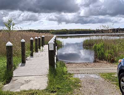
The Dock and Ramp at Chapman Pond
Photography by: Shaughn Robinson
Date of Photograph: May 15, 2026
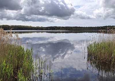
Chapman Pond from the Boat Ramp
Photography by: Shaughn Robinson
Date of Photograph: May 15, 2026
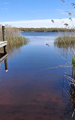
Chapman Pond from the Boat Ramp
Photography by: Shaughn Robinson
Date of Photograph: May 15, 2026
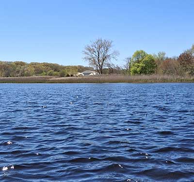
Chapman Pond
Photography by: Shaughn Robinson
Date of Photograph: May 15, 2026
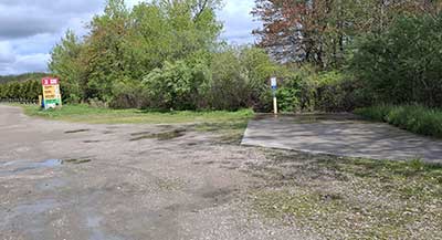
The Parking Area for the Boat Ramp
Photography by: Shaughn Robinson
Date of Photograph: May 15, 2026
Do you have comments, corrections or additions to the information about this site?
Help us work together to make this website better by sharing your knowledge!


Private feedback goes to the Blueways Alliance/RI Land Trust Council. We'll use your information to make this website better or pass it along to the people who can deal with physical issues at this site. Public comments are posted here (once they've been reviewed and approved) for all to see.
The data on this website come from many sources, including volunteers and organizations across the state of Rhode Island and nearby parts of Massachusetts. We have done our best to make sure the data are accurate and up to date, but any information critical to the success of your trip should be confirmed before you start. The maps and information on this website should not be substituted for nautical charts, topographic maps, or other more detailed maps and guides. We welcome corrections and additions. To send a correction or provide other feedback, please use our feedback form (see link above).
This site report was last updated on May 19, 2026
Comments:
Help is on the Way for Chapman Pond!
Submitted by: Anonymous; August 23, 2021; 3:14 pm
The Town of Westerly recently installed a solar-powered free boat cleaning station at Chapman Pond so that all boaters (motorized and non-motorized) can remove all bits of aquatic plants from their boats, trailers, bilges, motors, etc., after you've removed your boat from Chapman Pond. It's CRUCIAL that all boaters remove all traces of plant matter BEFORE leaving the area, including emptying bait boxes, bilges, etc. so the invasive plants that plague Chapman Pond aren't spread elsewhere. Please use this free boat cleaning station to prevent the problems that have developed here spreading throughout the state. This solar boat cleaning station was funded in part by EPA, and RIDEM and by the Town of Westerly.
In addition, the Town of Westerly has received a grant from DEM to work with a consultant to develop a Lake Management Plan to address the aquatic invasive plants in the pond as well as any polluted runoff that enters the pond. It's anticipated that the Plan will be written during the winter of 2021/2022 and the town will be able to start implementing its suggestions starting in 2022.
Rating:
Updated boat ramp
Submitted by: wstlyguy; May 30, 2020; 4:37 am
Recently rebuilt. The ramp seems well done. There is now a small dock running parallel to the ramp. The grasses and weeds begin to take over the shoreline by early summer. The lot is not well maintained after the rebuild and there are many ruts in the gravel that could swallow a small car. The town seems uninterested in maintaining the work done to the land and come late summer the weeds in the gravel make it hard to tell where the roads are. It’s a quiet spot though. Mostly used for overflow parking from the adjacent, well manicured dog park.
Rating: