Lavins Landing Marina
41º21'30.17" N 71º41'21.26" W See this location in: Google Maps Map Server Acme Maps
This is a site for launching boats from trailers. Boat ramps can normally be used to launch canoes and kayaks but please do your best to keep the boat ramp clear for boat trailers.
Comments & Overview:
This boat ramp at the private Lavins Landing Marina is available to the public for launching boats for a fee of $10/day. This site provides access to the main body of Ninigret Pond. There are a variety of opportunities on the pond for exploring and fishing in relatively sheltered waters. You can also paddle a mile across the pond to the Ninigret Conservation Area barrier beach. Keep an eye out for boat traffic on the pond. Before planning to launch from this boat ramp it would be a good idea to call the marina (401-322-7277) and confirm the price and parking arrangements.
This site provides access to the following water bodies in the Coastal Watersheds (West Bay) watershed: Ninigret Pond.
Location:
Alternate Site Name: Sportsman Cove Marina
Town: Charlestown
Nearest Town Center: Charlestown
Driving Landmarks: From Route 1 north take the Meadow Lane exit and go 1/4 mile down Meadow Lane. The marina is on the left at the bend in the road. From Route 1 south go past Meadow Lane and use the next turnaround to get onto Route 1 north, and then follow the directions above.
Access & Waters:
Water 'Features' At Site: estuary
Note: Because one boat launch can access, say, both a lake and a river or both the upstream and downstream portions of a river, not all paddling trips at a given site will necessarily encounter all of the features listed.
Type of Access: Boat ramp
ADA Accessible Boat Launch? no
Shoreline: Hard surface boat ramp
Float/Dock: high dock (over 1' above water)
Hours of Operation: Sunrise to sunset, year-round
Fees: $10/day
Parking:
Parking: parking lot, 40 spaces
Sources for More Information:
Other Guidebooks: Salt Ponds Coalition Kayaker's Guide
Website: Salt Ponds Coalition Kayaker's Guide to the Salt Ponds of South County, Rhode Island
Photographs:

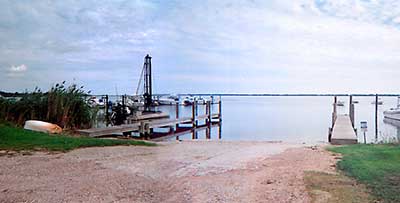
Lavins Landing Marina Boat Ramp
Photography by: Art Ganz and Bambi Poppick
Date of Photograph: September 6, 2006
Do you have comments, corrections or additions to the information about this site?
Please help make this website better by sharing your knowledge! Feedback Form
The data on this website comes from many sources, including volunteers and organizations across the state of Rhode Island and nearby parts of Massachusetts. We have done our best to make sure the data are accurate and up to date, but any information critical to the success of your trip should be confirmed before you start. The maps and information on this website should not be substituted for nautical charts, topographic maps, or other more detailed maps and guides. We welcome corrections and additions. To send a correction or provide other feedback, please use our feedback form (see link above).
This site report was last updated on July 14, 2008

