

 Hayward Street Launch
41° 59.866' N 70° 57.246' W See this location in: Google Maps Map Server Acme Maps
This is a site for launching hand-carried boats such as canoes or kayaks.
Description & Overview:
Hayward Street provides the first reasonable access to the Town River below the section of the river through Bridgewater, below High Street, that is effectively closed to paddling. The path down to the river is short but somewhat steep and goes straight down to the river from the back of the parking area off Hayward Street.
From the river, the take-out at Hayward Street can be easy to miss. If paddling downriver it is on the left about 200 feet before the bridge, and before you can see the bridge.
The river is very slow moving above Hayward Street and you can paddle upriver for some distance if you want to. This will take you through a nice wetland. In about 1.3 miles you will come to the first of many downed trees that block the river through Bridgewater. Here you should turn around and head back downriver unless you enjoy struggling to get your boat over and around numerous downed trees.
Heading downriver from Hayward Street, if the river is low you may have to get out and lift your boat over rocks and shallow areas a few times for the first 150 yards or so below the bridge. In higher water there may be a bit of quickwater through here. Then the river slows down again and slowly gets deeper. The topographic map and Google map of the area give the impression that the river enters a pond not far below Hayward Street. This was true when the Reynolds Dam below MA 104 was higher. Now this dam is largely broken down and the river below Hayward Street winds through a nice wetland with growth too high to see over for most of the way. Aerial photographs (Google Maps satellite view) give a more accurate picture of the current situation.
In 1.1 miles you will come to a junction, where the Matfield River flows in from the left. This is the end of the Town River and the start of the Taunton River. You can explore up the Matfield for half a mile or so (to the first bridge, where there is a bit of quickwater) or go right at the junction to start down the Taunton River. In 0.3 miles you will come to the MA 104/Plymouth Street bridge, which can be used as a take-out (on the right before the bridge), but it is not a very good one due to the lack of parking and steep riverbanks.
A few hundred feet below the MA 104 bridge you will come to the broken-down remnants of the old Reynolds Dam. If conditions and the experience level of your group allow, this dam can be run (with care) on the left. If the river is not too high it can also be portaged on the right, going right over the old dam remnants. If the right side of the dam is underwater then you will have to run the dam or undertake a portage through thick brush and poison ivy.
Below the dam the river slows down again and enters the deep forest through which the Taunton River flows for much of its length. It is 2-1/2 miles from the Reynolds Dam to Cherry Street, the first bridge and the first possible take-out. There are no houses or buildings or even roads visible from the river in this area and in many areas you would have to go a long ways back from the river to find the first road or house. There are quite a few trees down across the river. In some cases you can go around, over or under them without getting out of your boat. However, especially when the river is very low many of these trees block the river all the way across, meaning you will have to get out and pull your boat over them or bushwhack around them. Even when the water levels are higher you should expect some challenges getting past the bigger trees that have fallen across the river. The river is deep and slow moving, and as it winds its way through the thick forest you can feel like you have been transported back to some other century.
The take-out at Cherry Street is below the bridge on the left side of the river. It is somewhat muddy and steep but is usable. For more details, see the description for Cherry Street.
This site provides access to the following water bodies in the Taunton River watershed: Taunton River, Town River.
Location:
Town: Bridgewater
Nearest Town Center: Bridgewater Center
Driving Landmarks: From the center of Bridgewater, head east on MA 104 (Summer Street). Bear left to stay on MA 104 when Summer Street bears off to the right. This will put you on Plymouth Street. 1.1 miles from the center of Bridgewater, turn left onto Hayward Street. Go 0.4 miles on Hayward Street, bearing left at the junction with Whitman Street, and look for a dirt parking area on the left, just after you cross the river.
Access & Waters:
Water 'Features' At Site: flatwater/slow moving river
Note: Because one boat launch can access, say, both a lake and a river or both the upstream and downstream portions of a river, not all paddling trips at a given site will necessarily encounter all of the features listed.
Type of Access: Boat launch for hand carried boats
ADA Accessible Boat Launch? no
Shoreline: Small gravel area with thick vegetation on both sides
Float/Dock: no
Approximate Length of Carry between Car Access and Water: 40 feet
Parking:
Parking: yes: 6 spaces
ADA Accessible Parking Spaces? no
Nearby Amenities:
Public Restrooms: No
Sources for More Information:
AMC River Guide: 4th Edition, page 153
Photographs:
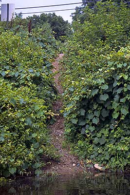
The Path to the River at Hayward Street
Photography by: Bruce G. Hooke
Date of Photograph: July 15, 2010
This is what the path to the river at Hayward Street looks like from the river...short but a bit steep.
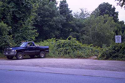
The Parking Area at Hayward Street
Photography by: Bruce G. Hooke
Date of Photograph: July 15, 2010
The short path down to the river starts just to the left of the white sign.
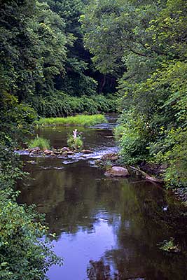
View Downriver from the Hayward Street Bridge
Photography by: Bruce G. Hooke
Date of Photograph: July 15, 2010
At this river level you will have to get out occasionally to lift your boat over rocks, but only for the first 150 yards or so below the bridge.
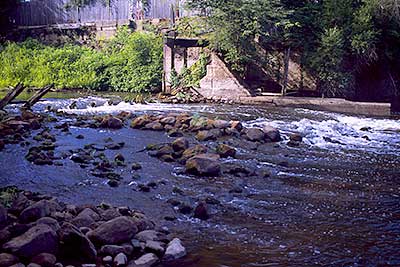
Reynolds Dam
Photography by: Bruce G. Hooke
Date of Photograph: July 15, 2010
The broken down Reynolds Dam is 1.45 miles below Hayward Street, and just below the MA 104 bridge.
Do you have comments, corrections or additions to the information about this site?
Help us work together to make this website better by sharing your knowledge!


Private feedback goes to the Blueways Alliance/RI Land Trust Council. We'll use your information to make this website better or pass it along to the people who can deal with physical issues at this site. Public comments are posted here (once they've been reviewed and approved) for all to see.
The data on this website come from many sources, including volunteers and organizations across the state of Rhode Island and nearby parts of Massachusetts. We have done our best to make sure the data are accurate and up to date, but any information critical to the success of your trip should be confirmed before you start. The maps and information on this website should not be substituted for nautical charts, topographic maps, or other more detailed maps and guides. We welcome corrections and additions. To send a correction or provide other feedback, please use our feedback form (see link above).
This site report was last updated on June 7, 2026
Comments:
Hayward Street to Cherry Street Bridge
Submitted by: Kurt Mahoney; June 7, 2026; 10:12 am
My friend and I kayaked from the Hayward St. launch to the Cherry St. Bridge take-out on the Taunton River in about 5 hours - can confirm that the information in this description is still accurate. This section is not recommended for beginners due to the numerous downed trees and debris that need to be navigated, especially after the start of the Taunton River. Two particularly large blow-downs crossed the entire river and required annoying bushwhack portages to bypass; this will probably be even more difficult later in summer when the brush gets thicker. It was likely possible to drag our boats over these, but we didn't want to risk getting into the cold early-season water. We ran the old Reynolds Dam through the middle, which definitely got the adrenaline flowing but is doable for an experienced paddler.
We started our trip by exploring upriver towards West Bridgewater from Hayward St, which is pretty easygoing until you encounter a downed tree blocking the entire river about 1.2 miles up. We did not attempt to cross this, so couldn't confirm how difficult it would be to navigate from launches further up the Town River.
Rating:
Photographs:
Photo Credit: Kurt Mahoney
Photo Credit: Kurt Mahoney