

 Riverdale Mills Portage
42° 8.357' N 71° 38.396' W See this location in: Google Maps Map Server Acme Maps
This site is a portage. This typically means there either is no road access to this location or that the site is not recommended as a launching site for some other reason. The portage may be around a dam, whitewater, or some other obstruction.
Description & Overview:

While there is road access to this site it is signed "private property" and there is much better parking and river access at Plummer's Landing, a mile downriver. However, if you are paddling down the river from above Riverdale Mills you will have to portage around the dam at Riverdale Mills. If possible, take out on the left side of the river before the footbridge and carry up to the dirt track the runs parallel to the river. From there look for a path leading down to the river. There is lots of poison ivy in the area so be careful what you touch. The path should get you to a gravel bar where you can put into the river but this is a strenuous portage.
If you can't take out on river left you'll have to take out in front of the mill and carry over the footbridge. Ignore the sign pointing the wrong way to a non-existent portage somewhere to the west.
Either way, this is a strenuous portage.
Below the dam the river is a mix of flatwater and quickwater. The riverbanks below Riverdale are largely wooded and rural for many miles, with only very occasional houses and buildings visible from the river.
NOTE: There are ongoing issues with pollution in the Blackstone River. Great strides have been made in cleaning up the river relative to where it was a generation or two ago but under some conditions the water may still have a noticeable odor.
This site provides access to the following water bodies in the Blackstone River watershed: Blackstone River.
Location:
Town: Northbridge
Nearest Town Center: Northbridge, MA
Access & Waters:
Water 'Features' At Site: dam, whitewater, flatwater/slow moving river, pond
Note: Because one boat launch can access, say, both a lake and a river or both the upstream and downstream portions of a river, not all paddling trips at a given site will necessarily encounter all of the features listed.
Type of Access: Portage
ADA Accessible Boat Launch? no
Shoreline: Grass above the dam, gravel and rocks below the dam.
Float/Dock: no
Portage Length: 450 feet
Parking:
Parking: no
Sources for More Information:
Website: Blackstone Heritage Corridor National Park - Get On the River Page
Photographs:
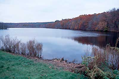
View Up River from Riverdale Mills
Photography by: Bruce Hooke
Date of Photograph: November 3, 2008
This is a view up river across the pond created by the dam at Riverdale Mills. This photograph was taken from in front of the mill. The better portage is on the other side of the river and dam.
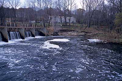
The River below Riverdale Mills Dam
Photography by: Bruce Hooke
Date of Photograph: November 3, 2008
This view shows the lower part of the Riverdale Mills dam and a bit of the river below the dam. The put-in is on the far shore, at the right edge of the picture. The gravel bar in the middle of the picture has a steep bank behind it. Stay on top of this bank and walk past this gravel bar to the low bar on the right, where there is better access. The footbridge over the river is above the upper dam and not in this picture. The foam on the river is from the water falling over the large dam just upstream.
Do you have comments, corrections or additions to the information about this site?
Help us work together to make this website better by sharing your knowledge!

Private feedback goes to the Blueways Alliance/RI Land Trust Council. We'll use your information to make this website better or pass it along to the people who can deal with physical issues at this site. Public comments are posted here (once they've been reviewed and approved) for all to see.
The data on this website come from many sources, including volunteers and organizations across the state of Rhode Island and nearby parts of Massachusetts. We have done our best to make sure the data are accurate and up to date, but any information critical to the success of your trip should be confirmed before you start. The maps and information on this website should not be substituted for nautical charts, topographic maps, or other more detailed maps and guides. We welcome corrections and additions. To send a correction or provide other feedback, please use our feedback form (see link above).
This site report was last updated on September 21, 2020