

 River Bend Farm
42° 5.652' N 71° 37.39' W See this location in: Google Maps Map Server Acme Maps
This is a site for launching hand-carried boats such as canoes or kayaks.
Description & Overview:

This site provides great access to a 1 1/4 mile long section of the Blackstone Canal that can be explored by canoe or kayak. There are a couple of ponds on the canal, the largest being the pond at River Bend Farm, so it is not all straight canal paddling. You can get to the river from either end of the canal, which also makes it possible to do a loop trip down the river and then back up the canal. See the description for the put-in at Rice City Pond for more details on the river in this area.
This site provides access to the following water bodies in the Blackstone River watershed: Blackstone Canal.
Location:
Alternate Site Name: Blackstone River and Canal Heritage State Park
Town: Uxbridge
Nearest Town Center: Uxbridge, MA
Driving Landmarks: From Route 122 go east on "Hartford Avenue East" for 1 mile. Turn right onto Oak Street, where there are is state park sign and a "visitor center" sign. Go 0.1 miles down Oak Street and look for Blackstone River and Canal Heritage State Park/River Bend Farm Visitors Center on your left.
Access & Waters:
Water 'Features' At Site: canal
Note: Because one boat launch can access, say, both a lake and a river or both the upstream and downstream portions of a river, not all paddling trips at a given site will necessarily encounter all of the features listed.
Type of Access: Boat launch for hand carried boats
ADA Accessible Boat Launch? no
Shoreline: sand
Float/Dock: low float or dock
Approximate Length of Carry between Car Access and Water: 50 feet
Hours of Operation: sunrise to sunset
Parking:
Parking: yes: 200 spaces
ADA Accessible Parking Spaces? yes
Nearby Amenities:
Public Restrooms: Yes, at the visitors center
Sources for More Information:
AMC River Guide: 4th Edition, page 151-152
Website: MA DCR website for the Blackstone River and Canal Heritage State Park
Ecological, Cultural & Recreational Attractions:
Blackstone River and Canal Heritage State Park has extensive walking trails, historical information, picnic tables and other interesting attractions. See the website (link below) for more details.
Photographs:
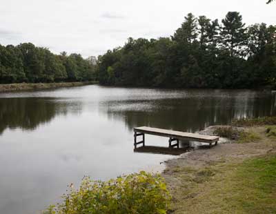
The Put-in at River Bend Farm
Photography by: Bruce Hooke
Date of Photograph: September 18, 2020
This photograph was made during a drought when the water level was unusually low.
Do you have comments, corrections or additions to the information about this site?
Help us work together to make this website better by sharing your knowledge!

Private feedback goes to the Blueways Alliance/RI Land Trust Council. We'll use your information to make this website better or pass it along to the people who can deal with physical issues at this site. Public comments are posted here (once they've been reviewed and approved) for all to see.
The data on this website come from many sources, including volunteers and organizations across the state of Rhode Island and nearby parts of Massachusetts. We have done our best to make sure the data are accurate and up to date, but any information critical to the success of your trip should be confirmed before you start. The maps and information on this website should not be substituted for nautical charts, topographic maps, or other more detailed maps and guides. We welcome corrections and additions. To send a correction or provide other feedback, please use our feedback form (see link above).
This site report was last updated on September 21, 2020