

 Mendon Street (Route 16)
42° 4.755' N 71° 37.174' W See this location in: Google Maps Map Server Acme Maps
This is a site for launching hand-carried boats such as canoes or kayaks.
Description & Overview:

The dirt parking area here is right next to the river so it is a very short carry from your car to the river. The put-in is just below a short class I whitewater drop, which must be run if you are paddling down river to this site. Below this put-in the river is a mix of flatwater and quickwater. The Mumford River enters on the right 1/4 mile below the put-in and the West River enters on the left in another mile.
For the first two miles below Route 16 there are numerous tight bends in the river and many strainers (trees down in the river) so especially if the river is at all high, this can be a challenging paddle!
The riverbanks in this area are largely wooded with only occasional houses, roads and commercial buildings visible from the river.
The map and guide created by the Blackstone Valley Heritage Corridor is highly recommended for paddling this section of the Blackstone River. It can be downloaded from the park website at the link below.
NOTE: There are ongoing issues with pollution in the Blackstone River. Great strides have been made in cleaning up the river relative to where it was a generation or two ago but under some conditions the water may still have a noticeable odor.
This site provides access to the following water bodies in the Blackstone River watershed: Blackstone River.
Location:
Alternate Site Name: Stanley Woolen Mill
Town: Uxbridge
Nearest Town Center: Uxbridge, MA
Driving Landmarks: From Route 122 or Route 146 take Route 16 east. Just after the junction with Route 122 you will cross the Mumford River. Keep going for another 1/2 mile and look for a dirt road on the right just after you cross the Blackstone River. The entrance to the road is small but if you follow it back you will come to a small dirt parking area next to the river and a turn-around.
Access & Waters:
Water 'Features' At Site: whitewater, flatwater/slow moving river
Note: Because one boat launch can access, say, both a lake and a river or both the upstream and downstream portions of a river, not all paddling trips at a given site will necessarily encounter all of the features listed.
Type of Access: Boat launch for hand carried boats
ADA Accessible Boat Launch? no
Shoreline: sand
Float/Dock: no
Approximate Length of Carry between Car Access and Water: 20 feet
Parking:
Parking: yes: 14 spaces
ADA Accessible Parking Spaces? no
Sources for More Information:
AMC River Guide: 4th Edition, page 151-152
Photographs:
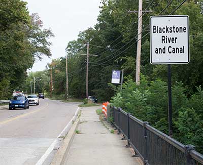
The Bridge over the River
Photography by: Bruce Hooke
Date of Photograph: September 18, 2020
The road to the put-in is on the right, just after the purple sign and the traffic cones, which likely won't be there in the future.
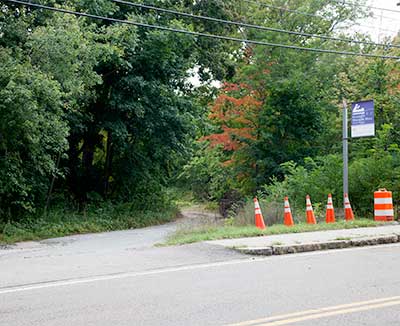
The Gravel Road to the Put-in
Photography by: Bruce Hooke
Date of Photograph: September 18, 2020
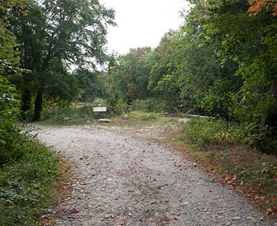
The Small Parking Area Beside the River
Photography by: Bruce Hooke
Date of Photograph: September 18, 2020
The road continues a little further to a turn-around next to the steps leading to the river.
The Steps to the River
Photography by: Bruce Hooke
Date of Photograph: September 18, 2020
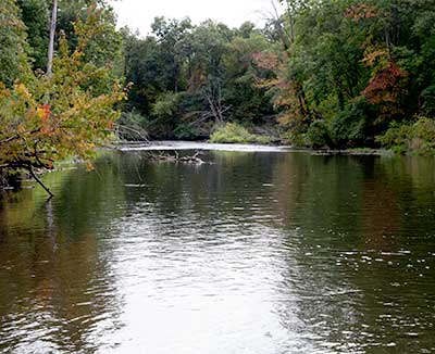
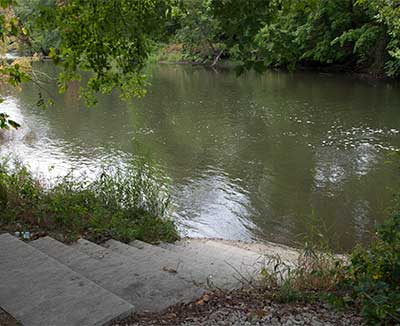
A View Downriver from the Put-in
Photography by: Bruce Hooke
Date of Photograph: September 18, 2020
This photograph was made in the fall, during a drought, when the river was low.
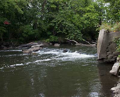
A View Upriver from the Put-in
Photography by: Bruce Hooke
Date of Photograph: September 18, 2020
This photograph shows the rapid (created by the remains of an old dam) that must be run if paddling downriver to this site. This photograph was made in the fall, during a drought, when the river was low. Be prepared for conditions to be different when the river is higher.
Do you have comments, corrections or additions to the information about this site?
Help us work together to make this website better by sharing your knowledge!

Private feedback goes to the Blueways Alliance/RI Land Trust Council. We'll use your information to make this website better or pass it along to the people who can deal with physical issues at this site. Public comments are posted here (once they've been reviewed and approved) for all to see.
The data on this website come from many sources, including volunteers and organizations across the state of Rhode Island and nearby parts of Massachusetts. We have done our best to make sure the data are accurate and up to date, but any information critical to the success of your trip should be confirmed before you start. The maps and information on this website should not be substituted for nautical charts, topographic maps, or other more detailed maps and guides. We welcome corrections and additions. To send a correction or provide other feedback, please use our feedback form (see link above).
This site report was last updated on September 21, 2020