

 India Point Park
Providence, City of Providence

1.5 miles of trail at this site are wheelchair and stroller-friendly, however, these trails may not meet ADA standards.
Click on the "Trail Map (PDF)" button to download a PDF of the trail map that you can print and take with you on the trail.
Avenza maps are special, free maps that you can use in the Avenza app on your smart phone. These maps let you see your location on the map as you walk. Download the Avenza App for free in the Apple App Store or on Google Play
Click on the Avenza Trail Map button to "purchase" the free map for this trail from the Avenza map store. If this is your first time, Avenza will ask you to set up an account to check out. However, all Avenza trail maps listed on ExploreRI are free.
In Rhode Island the primary hunting seasons typically run from the second Saturday in September to the last day of February and from the third Saturday in April to the last day in May, however this can vary from year to year and depends on what game is being hunted. During hunting season you should wear at least 200 square inches (a hat OR a vest) of blaze orange. During shotgun deer season, which is typically in December, you should wear at least 500 square inches of blaze orange (a hat AND a vest). For more information see the RI DEM website.
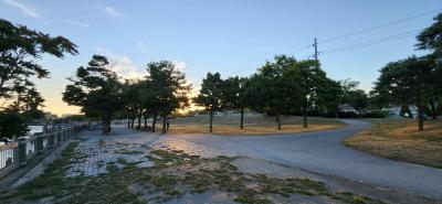


Located in the historic Fox Point neighborhood of Providence’s East Side, India Point Park is celebrated for its sweeping views of the Providence Harbor and Seekonk River. In addition to lighted, paved & stone dust walking paths along the water, the park includes a playground with ropes, swings and a sandbox. There is a ceremonial dock and a pedestrian bridge over Rt. 195 - connecting the park to the neighborhood. India Point Park is the location for the City’s annual 4th of July fireworks display, along with concerts and festivals throughout the summer. Seastreak & RIPTA operate a ferry to Newport from a dock adjacent to the park.
India Point Park has a rich history as the hub of Providence sea commerce, and in the early 19th century, it was even the location of the first Providence train station. Passengers would arrive from Boston by train and take a boat the rest of the journey to New York City. The pilings visible in the water are remnants of the warehouses that sprung up along the waterfront. As shipping declined, the area along the river was used as a scrap yard.
In 1974, environmentalist Mary Elizabeth Sharpe pushed the city to turn the land into a public park. She convinced the mayor to match her $153,000 pledge and proposed a renovation that included playgrounds, picnic areas, bike paths, a promenade, and a boathouse. The park is now stewarded by the Friends of India Point Park

India Street Entrance
Driving Landmarks: Follow Gano Street southbound until it turns into India Street as you approach the park. The parking lot is just ahead on the left. In addition to the parking lot there is extensive roadside parking along India Street adjacent to the park.
Parking: Yes: Parking lot, 30 spaces, no overnight parking
ADA Accessible Parking Spaces? Yes
Coordinates: 41° 49.072' N 71° 23.428' W See this location in: Google Maps Acme Maps
The RIPTA 92 bus passes near the park on Wickendon Street. Get off near East Street and follow East Street two blocks to the footbridge over the highway
The Providence side of the East Bay Bike Path begins as the park
KEY:
Trailhead
Only trailheads related to this trail system are shown on this map. To see all trailheads go to the main map.
Do you have comments, corrections or additions to the information about this site?
Help us work together to make this website better by sharing your knowledge!


Private feedback goes to the Blueways Alliance/RI Land Trust Council. We'll use your information to make this website better or pass it along to the people who can deal with physical issues at this site. Public comments are posted here (once they've been reviewed and approved) for all to see.
The data on this website come from many sources, including volunteers and organizations across the state of Rhode Island and nearby parts of Massachusetts. We have done our best to make sure the data are accurate and up to date, but any information critical to the success of your trip should be confirmed before you start. The maps and information on this website should not be substituted for topographic maps or other more detailed maps and guides. We welcome corrections and additions. To send a correction or provide other feedback, please use our feedback form (see link above).
This site report was last updated on May 11, 2022
Comments:
Great park!
Submitted by: Anonymous; October 17, 2022; 5:56 pm
Great park next to college hill!
Rating:
Beautiful park in the city
Submitted by: Kelly Halstead; August 6, 2022; 4:26 pm
Perfect spot for a stroll anytime of day!! I love having a picnic in the shade of beautiful blooming trees. Picturesque sunsets!!
Rating:
Photographs:
Photo Credit: Kelly Halstead
No Restrooms unless there is a concert or festival
Submitted by: Hygiene for Providence; June 20, 2022; 8:07 am
There are no permanent restrooms at this park. There is no separation from bicycles and pedestrians on the walkways. The cyclists are a danger particularly on the stairway entrance.
Rating:
Where to pee
Submitted by: Anonymous; June 7, 2021; 11:39 am
Any out houses?
Rating: