

 Woonasquatucket River Greenway Bike Path
Providence, Johnston, City of Providence

3.9 miles of trail at this site are wheelchair and stroller-friendly, however, these trails may not meet ADA standards.
Click on the "Trail Map (PDF)" button to download a PDF of the trail map that you can print and take with you on the trail.
Avenza maps are special, free maps that you can use in the Avenza app on your smart phone. These maps let you see your location on the map as you walk. Download the Avenza App for free in the Apple App Store or on Google Play
Click on the Avenza Trail Map button to "purchase" the free map for this trail from the Avenza map store. If this is your first time, Avenza will ask you to set up an account to check out. However, all Avenza trail maps listed on ExploreRI are free.
In Rhode Island the primary hunting seasons typically run from the second Saturday in September to the last day of February and from the third Saturday in April to the last day in May, however this can vary from year to year and depends on what game is being hunted. During hunting season you should wear at least 200 square inches (a hat OR a vest) of blaze orange. During shotgun deer season, which is typically in December, you should wear at least 500 square inches of blaze orange (a hat AND a vest). For more information see the RI DEM website.
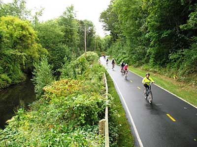
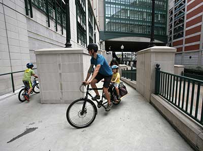

The Woonasquatucket River Greenway Bike Path runs from downtown Providence up the Woonasquatucket River to Lyman Avenue in Johnston. In many places it runs close beside the river, passing through woods, parks and neighborhoods. The first part of the path, closest to downtown, is mostly an on-road bike path but there are off-road portions in the Eagle Square Area and at Donigian Park. Starting in Riverside Park the trail is off road for 2.3 miles, all the way to the west end of the trail at Lyman Avenue in Johnston.
"Creating a Greenway along the Woonasquatucket River was the goal of a group of visionaries, led by Fred Lippitt and Jane Sherman. They wanted to spark revitalization in a low status neighborhood in the capital city, Olneyville, and identiï¬ed a potential source to anchor its revitalization — the Woonasquatucket River." (WRWC)
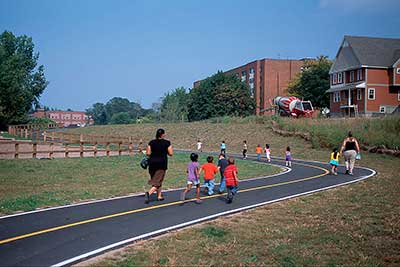
Riverside Park, Donigian Park and Merino Park, all accessed by the bike path, have playing fields, playgrounds, community gardens, and even a community bike shop in Riverside Park called the Red Shed Bike shop. The Woonasquatucket River Watershed Council runs many programs in the parks and along the river.
There are approximately 7 total miles of bike path, of which nearly 4 miles are off-road, but some of these miles are branches leading to parks and access points.
The bike path can be accessed in many places. Listed below are some good points for accessing the path but see the map for more options. As there is no parking at the western end of the bike path, at Lyman Avenue, this is not listed as an access point, but if you are reaching the bike path on your bicycle or on foot this is a fine access point.
Here are some of the highlights of the bike path and the parks along the path:
Donigian Park: basketball, futsal field, soccer, kayak launch, playground
Rising Sun Mills: Murals by Nick Guilbert, Fish Ladder
Riverside Park: Mural and sculptures by local artists, playground, picnic area, fish ladder, bike program, stage, fish ladder, historic artifacts, community garden, parking
Manton Gateway: Skate Park (phase II coming in 2020)
Merino Park: Playground, Soccer, basketball
Adventure Park (next to Merino Park): BMX pump track, cyclo cross track, parkour course,
Button Hole Golf Course: driving range, 9 hole golf course
Manton Pond Fish Ladder: Just down Goldsmith Street from the bike path, on the right, you can see a "nature-like" fish ladder. Goldsmith Street is just past Greenville Avenue on the bike path.
The Woonasquatucket River Watershed Council's page about the Greenway
Dogs: Dogs must be leashed and picked up after at ALL times.

Downtown Entrance
Driving Landmarks: The downtown end of the bike path starts under Providence Place Mall, near Waterplace Park. From Francis Street, in front of the mall, follow the underpass under the mall and the look for the bike path along Promenade Street.
Parking: Yes: On street, no overnight parking
Coordinates: 41° 49.652' N 71° 24.988' W See this location in: Google Maps Acme Maps
Donigian Park Entrance
Driving Landmarks: Donigian Park is on Valley Street, between Atwells Avenue and Olneyville Square. The path goes off-road here and runs along the river behind Rising Sun Mills.
Parking: Yes: On street, no overnight parking
Coordinates: 41° 49.394' N 71° 26.387' W See this location in: Google Maps Acme Maps
Riverside Park Trailhead
Driving Landmarks: Riverside Park is the start of the main off-road portion of the bike path. Riverside Park is on Aleppo Street, which branches off from Manton Avenue 2/10 mile from Olneyville Square.
Parking: Yes: On street, no overnight parking
Coordinates: 41° 49.192' N 71° 26.877' W See this location in: Google Maps Acme Maps
Merino Park Entrance
Driving Landmarks: Merino Park is across the river and the highway from the main route of the bike path but a spur of the bike path goes across a footbridge over the river and highway and then continues through Merino Park up along the south side of the river, rejoining the main bike path at Buttonhole Golf Course. By car, Merino Park is reached by taking a small street called Heath Street that branches off of Hartford Avenue just west of the highway (Route 6). Heath Street ends at a parking lot in the middle of the park.
Parking: Yes: Parking lot, 75 spaces, no overnight parking
Coordinates: 41° 49.24' N 71° 27.218' W See this location in: Google Maps Acme Maps
Hillside Avenue Entrance
Driving Landmarks: A small parking lot at Hillside Avenue provides a good access point to the western part of the bike path in Johnston. Hillside Avenue is a small side street off Manton Avenue/Greenville Avenue.
Parking: Yes: Parking lot, 9 spaces, no overnight parking
ADA Accessible Parking Spaces? Yes
Coordinates: 41° 49.951' N 71° 28.212' W See this location in: Google Maps Acme Maps
The downtown end of the bike path is 1/3 mile from Kennedy Plaza, served by many RIPTA buses. Many bus routes also pass various parts of the bike path further from downtown, including the 17, 19, 27, 28, 92.
KEY:
Trailhead
Only trailheads related to this trail system are shown on this map. To see all trailheads go to the main map.
Do you have comments, corrections or additions to the information about this site?
Help us work together to make this website better by sharing your knowledge!

Private feedback goes to the Blueways Alliance/RI Land Trust Council. We'll use your information to make this website better or pass it along to the people who can deal with physical issues at this site. Public comments are posted here (once they've been reviewed and approved) for all to see.
The data on this website come from many sources, including volunteers and organizations across the state of Rhode Island and nearby parts of Massachusetts. We have done our best to make sure the data are accurate and up to date, but any information critical to the success of your trip should be confirmed before you start. The maps and information on this website should not be substituted for topographic maps or other more detailed maps and guides. We welcome corrections and additions. To send a correction or provide other feedback, please use our feedback form (see link above).
This site report was last updated on February 12, 2020