

 Blackstone Park
Providence, City of Providence

![]() 0.3 miles
0.3 miles
0.3 miles of trail at this site are wheelchair and stroller-friendly, however, these trails may not meet ADA standards.
Click on the "Trail Map (PDF)" button to download a PDF of the trail map that you can print and take with you on the trail.
Avenza maps are special, free maps that you can use in the Avenza app on your smart phone. These maps let you see your location on the map as you walk. Download the Avenza App for free in the Apple App Store or on Google Play
Click on the Avenza Trail Map button to "purchase" the free map for this trail from the Avenza map store. If this is your first time, Avenza will ask you to set up an account to check out. However, all Avenza trail maps listed on ExploreRI are free.
In Rhode Island the primary hunting seasons typically run from the second Saturday in September to the last day of February and from the third Saturday in April to the last day in May, however this can vary from year to year and depends on what game is being hunted. During hunting season you should wear at least 200 square inches (a hat OR a vest) of blaze orange. During shotgun deer season, which is typically in December, you should wear at least 500 square inches of blaze orange (a hat AND a vest). For more information see the RI DEM website.
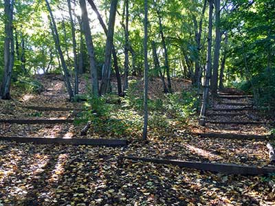
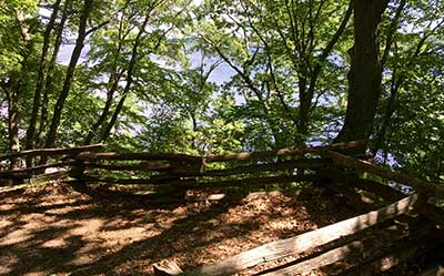
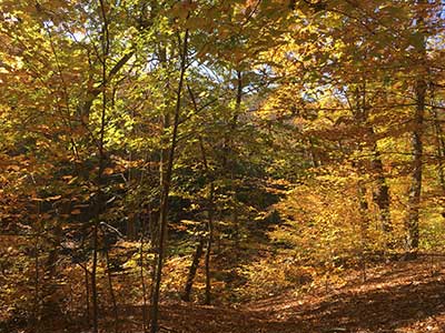

Blackstone Park is a 45-acre green oasis in the city, with a semi-wild character and many spots where the city vanishes from view. It's part of a wildlife corridor and great for spotting waterfowl and migratory birds. The park consists of forested sandy bluffs that drop to a lawn area, two ponds and an adjacent wetland. Historic features include two masonry trail entrances built by the Works Progress Administration during the Great Depression. Fall foliage is stunning, and in spring mountain laurels flower in the woods. A 1.4 acre restored area near the corner of Angell Street and Parkside Road showcases native plants. Most trails are shaded. Trails on the bluff top or next to the river have pretty views out over the Seekonk River estuary. The trails are steep in places; walkers who prefer flatter trails can stay on the bluff tops or walk along the sidewalk at the riverside edge of the park. Trails are regularly covered with wood chips but do have exposed roots, rocks, and erosion-control timbers. Trails can be muddy in winter and early spring.
The website of the Blackstone Parks Conservancy, which manages the park
Dogs: Dogs must be leashed and picked up after at ALL times.
Bicycles: Only on paved roads

Paterson Street Trailhead
Driving Landmarks: The Paterson Street entrance to the park is adjacent to the Paterson Park playground, at the intersection of Paterson Street and Rhode Island Avenue. A sign with trail maps and park information/rules is posted at the entrance.
Parking: Yes: On street, 15 spaces, no overnight parking
ADA Accessible Parking Spaces? No
Coordinates: 41° 49.83' N 71° 22.923' W See this location in: Google Maps Acme Maps
Angell Street Entrance
Driving Landmarks: This entrance is at the intersection of Angell Street and Parkside Road. The trail goes south into the park's South Section and (across the street) northeast into the park's Center Section. A sign with trail maps and park information/rules is posted at the entrance in the Center Section. There are two more trail entrances along Parkside Road, including one near the Parkside/Orchard Ave intersection, with a larger informational kiosk.
Parking: Yes: On street, 20 spaces, no overnight parking
ADA Accessible Parking Spaces? No
Coordinates: 41° 49.903' N 71° 22.793' W See this location in: Google Maps Acme Maps
River Drive Entrance
Driving Landmarks: This trail entrance is near the north end of Hockey Pond, just south of Angell Street on River Drive. At the trail entrance there is a sign with trail maps and park information and rules.
Parking: Yes: On street, 20 spaces, no overnight parking
ADA Accessible Parking Spaces? No
Coordinates: 41° 49.864' N 71° 22.765' W See this location in: Google Maps Acme Maps
Blackstone Field Entrance
Driving Landmarks: Just north of the intersection of Angell Street and River Drive, a grassy lawn on the left has two trail entrances. The Narragansett Boat Club building (painted blue) sits over the water directly across from this lawn. At the more southerly of the two entrances is a sign with trail maps and park information/rules.
Parking: Yes: On street, 20 spaces, no overnight parking
ADA Accessible Parking Spaces? No
Coordinates: 41° 49.961' N 71° 22.691' W See this location in: Google Maps Acme Maps
York Pond Entrance
Driving Landmarks: York Pond is near the intersection of River Drive and Irving Avenue. South of York Pond is a gravel access road (with a chain across) that provides a pedestrian entrance to the park. There is a sign with trail maps and park information/rules at the entrance.
Parking: Yes: On street, 10 spaces, no overnight parking
ADA Accessible Parking Spaces? No
Coordinates: 41° 50.107' N 71° 22.744' W See this location in: Google Maps Acme Maps
Irving Avenue Entrance
Driving Landmarks: There are two entrances into the park’s North Section along Irving Avenue: one near the river, at the intersection with River Drive, and another just uphill near the Irving/Loring Avenue intersection. At the entrance is a sign with trail maps and park information and rules. A third entrance on the south side of Irving (also at Loring Ave) leads to a wooded trail above a ravine.
Parking: Yes: On street, 15 spaces, no overnight parking
ADA Accessible Parking Spaces? No
Coordinates: 41° 50.17' N 71° 22.775' W See this location in: Google Maps Acme Maps
RIPTA bus routes 32, 33, 34, and 40 all pass through Wayland Square, which is about 1/2 mile from the park
The Blackstone River Bikeway passes through the park and connects to the East Bay Bike Path at India Point Park
KEY:
Trailhead
Only trailheads related to this trail system are shown on this map. To see all trailheads go to the main map.
Do you have comments, corrections or additions to the information about this site?
Help us work together to make this website better by sharing your knowledge!

Private feedback goes to the Blueways Alliance/RI Land Trust Council. We'll use your information to make this website better or pass it along to the people who can deal with physical issues at this site. Public comments are posted here (once they've been reviewed and approved) for all to see.
The data on this website come from many sources, including volunteers and organizations across the state of Rhode Island and nearby parts of Massachusetts. We have done our best to make sure the data are accurate and up to date, but any information critical to the success of your trip should be confirmed before you start. The maps and information on this website should not be substituted for topographic maps or other more detailed maps and guides. We welcome corrections and additions. To send a correction or provide other feedback, please use our feedback form (see link above).
This site report was last updated on February 13, 2020