

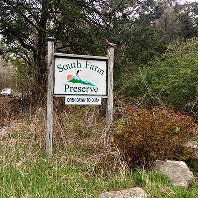
 South Farm Preserve
Charlestown, Town of Charlestown

0.6 miles of trail at this site are wheelchair and stroller-friendly, however, these trails may not meet ADA standards.
Hunting is not allowed here but it is permitted on nearby land. Wear blaze orange during hunting season. More information
Click on the "Trail Map (PDF)" button to download a PDF of the trail map that you can print and take with you on the trail.
Avenza maps are special, free maps that you can use in the Avenza app on your smart phone. These maps let you see your location on the map as you walk. Download the Avenza App for free in the Apple App Store or on Google Play
Click on the Avenza Trail Map button to "purchase" the free map for this trail from the Avenza map store. If this is your first time, Avenza will ask you to set up an account to check out. However, all Avenza trail maps listed on ExploreRI are free.
In Rhode Island the primary hunting seasons typically run from the second Saturday in September to the last day of February and from the third Saturday in April to the last day in May, however this can vary from year to year and depends on what game is being hunted. During hunting season you should wear at least 200 square inches (a hat OR a vest) of blaze orange. During shotgun deer season, which is typically in December, you should wear at least 500 square inches of blaze orange (a hat AND a vest). For more information see the RI DEM website.
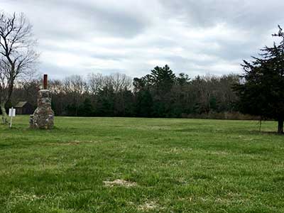

The South Farm Preserve is made up of two fields each with a trail around the perimeter and woodland trails at the southern end of the south trail. The fields are connected by a trail.
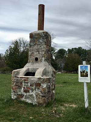
The preserve was originally a working farm and there is a restored sheep barn and the firebox of a sauna. On the far-right side of the north field, just off Old Coach Road, are the remains of the house, garden, and some old fruit trees. There is also a historic cemetery where many members of the Card family are buried. Most graves date back to the 1800s.
The trails are cut regularly, but the fields are home to birds and butterflies, and so are not cut until late in the year.
This 118-acre South Farm Preserve is adjacent to The Nature Conservancy’s more than 500-acre Pasquiset Pond Preserve.
Charlestown Conservation Commission web page
A short piece about this preserve on the Charlestown Citizens Alliance website
Dogs: Must be leashed or under voice command
Horses: Horses are permitted only on field perimeter trails and the trail connecting the two fields. Riders must pick up after their horse.

Old Coach Road Trailhead
Driving Landmarks: The parking lot is off Old Coach Road, across the road from a horse farm.
Parking: Yes: Parking lot, 12 spaces, no overnight parking
ADA Accessible Parking Spaces? Yes
Coordinates: 41° 25.183' N 71° 36.936' W See this location in: Google Maps Acme Maps
KEY:
Trailhead
Only trailheads related to this trail system are shown on this map. To see all trailheads go to the main map.
Do you have comments, corrections or additions to the information about this site?
Help us work together to make this website better by sharing your knowledge!

Private feedback goes to the Blueways Alliance/RI Land Trust Council. We'll use your information to make this website better or pass it along to the people who can deal with physical issues at this site. Public comments are posted here (once they've been reviewed and approved) for all to see.
The data on this website come from many sources, including volunteers and organizations across the state of Rhode Island and nearby parts of Massachusetts. We have done our best to make sure the data are accurate and up to date, but any information critical to the success of your trip should be confirmed before you start. The maps and information on this website should not be substituted for topographic maps or other more detailed maps and guides. We welcome corrections and additions. To send a correction or provide other feedback, please use our feedback form (see link above).
This site report was last updated on April 29, 2020