

 Schoolhouse Pond Preserve
Charlestown, Town of Charlestown

1.0 mile of trail at this site are wheelchair and stroller-friendly, however, these trails may not meet ADA standards.
Hunting is not allowed here but it is permitted on nearby land. Wear blaze orange during hunting season. More information
Click on the "Trail Map (PDF)" button to download a PDF of the trail map that you can print and take with you on the trail.
Avenza maps are special, free maps that you can use in the Avenza app on your smart phone. These maps let you see your location on the map as you walk. Download the Avenza App for free in the Apple App Store or on Google Play
Click on the Avenza Trail Map button to "purchase" the free map for this trail from the Avenza map store. If this is your first time, Avenza will ask you to set up an account to check out. However, all Avenza trail maps listed on ExploreRI are free.
In Rhode Island the primary hunting seasons typically run from the second Saturday in September to the last day of February and from the third Saturday in April to the last day in May, however this can vary from year to year and depends on what game is being hunted. During hunting season you should wear at least 200 square inches (a hat OR a vest) of blaze orange. During shotgun deer season, which is typically in December, you should wear at least 500 square inches of blaze orange (a hat AND a vest). For more information see the RI DEM website.
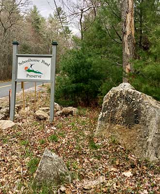

The Schoolhouse Pond Preserve is accessed from Kings Factory Road. You can park in the parking area, with Kiosk and maps, near Kings Factory Road and hike in approximately .5 miles to the pond or drive to a small parking area at the boulders and hike a shorter distance to the Pond. Note that land around the access road and preserve is all private property and Narragansett Native Tribal Land. Please respect their privacy.
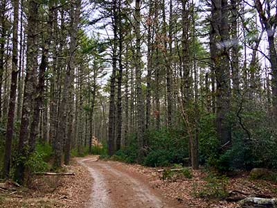
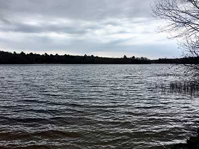
The trails are flat. The blue blazed trail initially provides you with pond views. A little further south is the former site of the early log cabin Narragansett Indian Schoolhouse. As the trail heads west, it turns into a network of trails and paths that runs through different forest types. The Schoolhouse Pond ecosystem is a rare community type (Coastal Plain Pond). Nesting boxes for wood ducks and small owls are placed throughout the property. How many can you find?
Note that swimming, off road bikes, and ATV’s are not permitted.
Charlestown Conservation Commission web page
A short piece about this preserve on the Charlestown Citizens Alliance website
Dogs: Must be leashed or under voice command

Kings Factory Road Parking Lot Trailhead
Driving Landmarks: Take the Kings Factory Road exit of Route 1 and go approximately 2 miles, and look for the trailhead on the right.
Parking: Yes: Parking lot, 6 spaces, no overnight parking
ADA Accessible Parking Spaces? Yes
Coordinates: 41° 24.466' N 71° 40.774' W See this location in: Google Maps Acme Maps
Schoolhouse Pond Trailhead ('The Boulders')
Driving Landmarks: Take the Kings Factory Road exit of Route 1 and go approximately 2 miles, and look for the entrance road on the right. To get to this trailhead drive past the first parking lot and continue to the end of the road. Note that Google gets the directions to this trailhead wrong so use the other trailhead for driving directions.
Parking: Yes: Parking lot, 5 spaces, no overnight parking
ADA Accessible Parking Spaces? Yes
Coordinates: 41° 24.241' N 71° 40.133' W See this location in: Google Maps Acme Maps
KEY:
Trailhead
Only trailheads related to this trail system are shown on this map. To see all trailheads go to the main map.
Do you have comments, corrections or additions to the information about this site?
Help us work together to make this website better by sharing your knowledge!

Private feedback goes to the Blueways Alliance/RI Land Trust Council. We'll use your information to make this website better or pass it along to the people who can deal with physical issues at this site. Public comments are posted here (once they've been reviewed and approved) for all to see.
The data on this website come from many sources, including volunteers and organizations across the state of Rhode Island and nearby parts of Massachusetts. We have done our best to make sure the data are accurate and up to date, but any information critical to the success of your trip should be confirmed before you start. The maps and information on this website should not be substituted for topographic maps or other more detailed maps and guides. We welcome corrections and additions. To send a correction or provide other feedback, please use our feedback form (see link above).
This site report was last updated on April 29, 2020