

 Westconnaug Meadows
Scituate, Scituate Land Trust

![]() 1.3 miles of trail
1.3 miles of trail
Moderate
Hunting is not allowed here but it is permitted on nearby land. Wear blaze orange during hunting season. More information
Click on the "Trail Map (PDF)" button to download a PDF of the trail map that you can print and take with you on the trail.
Avenza maps are special, free maps that you can use in the Avenza app on your smart phone. These maps let you see your location on the map as you walk. Download the Avenza App for free in the Apple App Store or on Google Play
Click on the Avenza Trail Map button to "purchase" the free map for this trail from the Avenza map store. If this is your first time, Avenza will ask you to set up an account to check out. However, all Avenza trail maps listed on ExploreRI are free.
In Rhode Island the primary hunting seasons typically run from the second Saturday in September to the last day of February and from the third Saturday in April to the last day in May, however this can vary from year to year and depends on what game is being hunted. During hunting season you should wear at least 200 square inches (a hat OR a vest) of blaze orange. During shotgun deer season, which is typically in December, you should wear at least 500 square inches of blaze orange (a hat AND a vest). For more information see the RI DEM website.
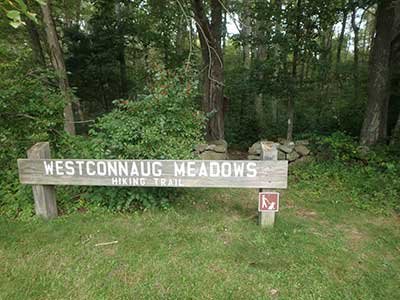
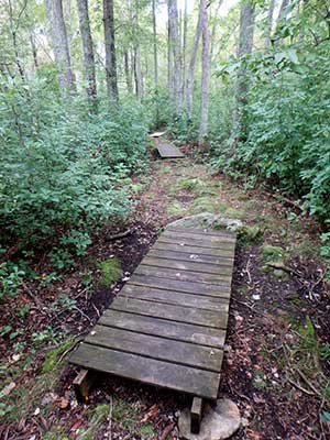

This property, owned by the Scituate Land Trust, offers a short trail that is just over a mile long. It is a good hike for beginners and children, and has been called one of the most peaceful, serene, and quiet hikes in Rhode Island. The trailhead is at the parking area for the ball fields on George Washington Highway in Clayville. Start at the north end of the parking lot where you will see a Westconnaug Meadows wooden sign. Cross through the gap in the stone wall and into the woodland. The trail first crosses two small boardwalks before turning right and slightly uphill into the thick of the woods. Along the way are several signs describing the types of trees such as black oak, red oak, white pine and sassafras, to name a few.
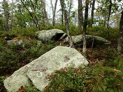
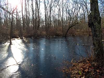
Follow the trail gradually uphill. The tree species change to mixed upland oaks as the site gets drier. At the fork in the trail, stay to the left and head down a short hill. As you walk, note small piles of stones and scattered American chestnut and witch hazel. This part of the trail is a loop. You will soon see yellow blazes and signs on your left that mark the Scituate Reservoir property, which is off limits and allows seasonal hunting. There is a small overlook along this stretch that gives you a view of the property to the west. You will be able to see a small stream and locate vernal pools down to the south (on your left). The pools will be full in the spring and dry in October. The trail slowly takes a series of small right turns passing some boulders left behind from the days of the glaciers. Soon the trail returns to the fork. Here, turn left and retrace your steps back to the parking lot. The entire trail is marked with brown plastic trail markers and is easy to navigate. The property is well preserved and maintained by the Land Trust and the Conservation Commission.
Town of Scituate Conservation Commission/Land Trust web page for Westconnaug Meadows
Dogs: Dogs must be leashed at all times.
This is a Creature Challenge site. The creature is on the Vernal Pool Loop.
Learn more about the Creature Challenge.

Trailhead
Driving Landmarks: The trailhead is beside a baseball field and just a bit north of the dog pound, on George Washington Highway, about 0.4 miles south of the junction with Field Hill Road.
Parking: Yes: Parking lot, 10 spaces, no overnight parking
ADA Accessible Parking Spaces? No
Coordinates: 41° 46' N 71° 40.3' W See this location in: Google Maps Acme Maps
KEY:
Trailhead
Only trailheads related to this trail system are shown on this map. To see all trailheads go to the main map.
Do you have comments, corrections or additions to the information about this site?
Help us work together to make this website better by sharing your knowledge!

Private feedback goes to the Blueways Alliance/RI Land Trust Council. We'll use your information to make this website better or pass it along to the people who can deal with physical issues at this site. Public comments are posted here (once they've been reviewed and approved) for all to see.
The data on this website come from many sources, including volunteers and organizations across the state of Rhode Island and nearby parts of Massachusetts. We have done our best to make sure the data are accurate and up to date, but any information critical to the success of your trip should be confirmed before you start. The maps and information on this website should not be substituted for topographic maps or other more detailed maps and guides. We welcome corrections and additions. To send a correction or provide other feedback, please use our feedback form (see link above).
This site report was last updated on September 21, 2023