

 Edward D. Vock Conservation Area
Burrillville, Burrillville Land Trust

![]() 1.0 miles of trail
1.0 miles of trail
Moderate
Hunting is not allowed here but it is permitted on nearby land. Wear blaze orange during hunting season. More information
Click on the "Trail Map (PDF)" button to download a PDF of the trail map that you can print and take with you on the trail.
Avenza maps are special, free maps that you can use in the Avenza app on your smart phone. These maps let you see your location on the map as you walk. Download the Avenza App for free in the Apple App Store or on Google Play
Click on the Avenza Trail Map button to "purchase" the free map for this trail from the Avenza map store. If this is your first time, Avenza will ask you to set up an account to check out. However, all Avenza trail maps listed on ExploreRI are free.
In Rhode Island the primary hunting seasons typically run from the second Saturday in September to the last day of February and from the third Saturday in April to the last day in May, however this can vary from year to year and depends on what game is being hunted. During hunting season you should wear at least 200 square inches (a hat OR a vest) of blaze orange. During shotgun deer season, which is typically in December, you should wear at least 500 square inches of blaze orange (a hat AND a vest). For more information see the RI DEM website.
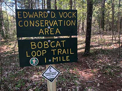

The Bobcat Loop tail is a one mile loop trail in the Edward D. Vock Conservation Area owned by the Burrillville Land Trust - a non-profit, private land trust in the Town of Burrillville. The loop trail begins at the trail head along Jackson Schoolhouse Road, in Pascoag, RI. The trail quickly moves through what use to be one of Rhode Island's original Tree Farms with a tree farm designation of #5. Hikers will see planted rows of old pines - some over 100 feet tall. The elevation increases as the trail goes along a glacial esker - a big linear pile of glacial outwash, mostly gravel and sand. On the far side of the esker is Leland Brook - the first of two water crossings. Leland Brook is part of the Leland Watershed and connects to the Clear River, the Branch River, and eventually the Blackstone River leading to Narragansett Bay. After the crossing look for depressions in the soil. People long ago dug up granite erratics - taking the sculpted stone away and leaving the hole behind and intact. About half way is Fox's Rock - a ledge out crop with a good view of the woodlands below. Be on the lookout for Rock Fern that grows between the crevices and Rock Tripe Fern that grows on the rock ledge. Rock Tripe Fern gets its nutrients directly from the rock. 3/4 of the way through you will cross the second water crossing. This is Carp Pond. The earthen damn was hand dug by Edward D. Vock and Carp placed in the pond for food. After the earthen damn crossing on your right is the beginnings of the American Chestnut orchard. The land trust is the first in the area to naturalize what we hope are disease resistant American Chestnut. American Chestnut grew all throughout this region. Remnants, known as sprouts, still pop out of the ground from existing tree stumps. Take a right onto Jackson Schoolhouse Road as the hike continues back to the trail head and parking. The pond on your left is Vock's Pond created by Mr. Vock to help power a small saw mill that is below the damn to your right. Be sure to read the sign honoring the family and especially Edward D. Vock.
NOTE: Hunting season takes place at various times during the year. Check with state regulations regarding hunting season to see when hunting takes place. You must wear orange during hunting season if you intend to walk the trail. The Edward D. Vock Conservation Area is not open to hunting and hunting is not allowed on this property at any time of the year. The trail and property boundaries are well marked. But sometimes hunters forget where they are or move into an area that they are unfamiliar with.
Burrillville Land Trust web page for the Vock Conservation Area
Dogs: Dogs should be leashed or have some type of protective collar so they don’t attack or chase after the resident wildlife. Hikers must clean up after their dogs and take it with them once they leave the area.
Horses: parking capacity is for 3 trailers. Must get in touch with the Burrillville Land Trust ahead of time (email paul@paulroselli.com). A donation is required - any amount)
This is a Creature Challenge site. The creature is on the Bobcat Trail.
Learn more about the Creature Challenge.

Bobcat Loop Trail Trailhead
Driving Landmarks: The trailhead is at the corner of Olney Keach Road and Jackson Schoolhouse Road in Pascoag, RI. The trailhead is clearly marked with a trail head sign and the trial with round silver metallic markers that that contain a silver colored hiker against a green background. Parking is along Jackson Schoolhouse Road and Olney Keach Road. Park on the opposite side of the street from the trailhead.
Parking: Yes: On street, 4 spaces, no overnight parking
ADA Accessible Parking Spaces? No
Coordinates: 41° 57.232' N 71° 44.567' W See this location in: Google Maps Acme Maps
KEY:
Trailhead
Only trailheads related to this trail system are shown on this map. To see all trailheads go to the main map.
Do you have comments, corrections or additions to the information about this site?
Help us work together to make this website better by sharing your knowledge!

Private feedback goes to the Blueways Alliance/RI Land Trust Council. We'll use your information to make this website better or pass it along to the people who can deal with physical issues at this site. Public comments are posted here (once they've been reviewed and approved) for all to see.
The data on this website come from many sources, including volunteers and organizations across the state of Rhode Island and nearby parts of Massachusetts. We have done our best to make sure the data are accurate and up to date, but any information critical to the success of your trip should be confirmed before you start. The maps and information on this website should not be substituted for topographic maps or other more detailed maps and guides. We welcome corrections and additions. To send a correction or provide other feedback, please use our feedback form (see link above).
This site report was last updated on September 21, 2023