

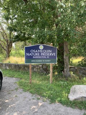
 Osamequin Nature Trails and Bird Sanctuary: 'First Bird' Trails
Barrington, Town of Barrington

![]() 1.5 miles of trail
1.5 miles of trail
Easy
Hunting is not allowed here but it is permitted on nearby land. Wear blaze orange during hunting season. More information
Click on the "Trail Map (PDF)" button to download a PDF of the trail map that you can print and take with you on the trail.
Avenza maps are special, free maps that you can use in the Avenza app on your smart phone. These maps let you see your location on the map as you walk. Download the Avenza App for free in the Apple App Store or on Google Play
Click on the Avenza Trail Map button to "purchase" the free map for this trail from the Avenza map store. If this is your first time, Avenza will ask you to set up an account to check out. However, all Avenza trail maps listed on ExploreRI are free.
In Rhode Island the primary hunting seasons typically run from the second Saturday in September to the last day of February and from the third Saturday in April to the last day in May, however this can vary from year to year and depends on what game is being hunted. During hunting season you should wear at least 200 square inches (a hat OR a vest) of blaze orange. During shotgun deer season, which is typically in December, you should wear at least 500 square inches of blaze orange (a hat AND a vest). For more information see the RI DEM website.
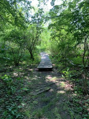
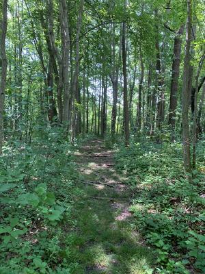
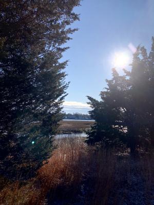
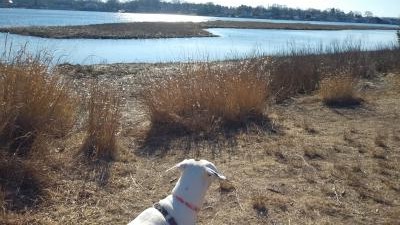
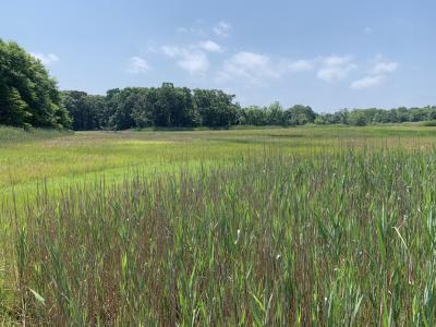


Osamequin Nature Sanctuary offers visitors a place to enjoy a diverse sample of Rhode Island's coastal plant and animal communities along the west shore of the Barrington River's Hundred Acre Cove, Rhode Island's most extensive and pristine inland estuarine system. This system has been noted by the US Fish and Wildlife Service to be one of the 50 most important coastal marshes between Long Island and Cape Code. The trail system on the preserve provides many views of the cove as well as the various habitats and environments within the preserve. The trails are all easy and flat and each habitat type is accessible to refuge visitors via the color coded trails which begin with the green trail at the park entrance. See the trail map for more details on the trail routes and colors. There are two parts to the preserve. What is being described here is the primary, "first bird," trail system. The second part, the "second bird" trail system, is about 0.7 mile north on Wampanoag Trail. See the separate listing for that "second bird" trail system.
As a result of sea level rise (seen here as higher high tides), the marsh plants and animals are migrating inland. As a result some trails have been relocated to higher ground. If you encounter flooded trails please use caution and when it doubt turn around and use a different trail. Please help the wildlife by staying on marked trails.
Osamequin is named in honor of the Massasoit or "Great Leader" of the Pokanoket Tribe of the Wampanoag Nation. All of Barrington was part of their homeland of Sowams. Massasoit Ousamequin prevented the failure of the Plymouth Colony and negotiated a peace treaty on March 22, 1621 that lasted over 50 years. For more information about the Pokanoket Tribe of the Wampanoag Nation visit the Pokanoket Facebook page.
Under the Green Acres program the Town of Barrington acquired the 42 acres of land that are Osamequin Nature Sanctuary and granted permission to the Barrington Garden Club to develop the area as a conservation area. Dedicated in May 1968, the management and maintenance by the Garden Club has continued ever since in cooperation with the Conservation Commission and the Department of Public Works.
There is something to offer in every season. Salt marsh islands in the cove are visible from the shoreline of the refuge - bring your binoculars for bird-watching. Horseshoe crabs lay eggs on the shoreline each spring. You might see a rare diamondback terrapin sunning upon a log or peeking up from the water. The only known nesting population of this terrapin in Rhode Island is at the Rayner Refuge across Hundred Acre Cove which also offers public hiking trails.
To access the preserve by bus use the Route 60 Newport Providence bus. On the Inbound (northbound) bus the stop is known as "Wampanoag Trail Opposite Primrose Hill Road." On the outbound (southbound) "Wampanoag Trail Far Side Primrose." The preserve is on the inbound side and since Wampanoag Trail is a divided highway it can be a problem getting to the far side stop since there are no crosswalks or crossing lights and the speed limits in the area are 40-45 mph.
Dogs: Yes. Dogs must be leashed and owners must pick up waste.

'First Bird' Trailhead
Driving Landmarks: This trailhead is right on Route 114 North, also known as County Road and Wampanoag Trail.
From the South take Route 114 North. You will pass Federal Road in Barrington -- the "White Church" (Congregational Church) bridge intersection -- and Walker's Farm, and then about 0.2 mile beyond the turnaround exit for Route 103 to Riverside look for a sign for the preserve on your right as well as a parking area next to the road.
From the North take Route 114 South to the turnaround exit on the left 0.15 miles south of Primrose Hill Road. Take this turnaround, which puts you on Route 114 north. Go 0.2 miles and look for a sign for the preserve on your right as well as a parking area next to the road.
Parking: Yes: Parking lot, 10 spaces, no overnight parking
ADA Accessible Parking Spaces? No
Coordinates: 41° 45.633' N 71° 19.367' W See this location in: Google Maps Acme Maps
Yes. Use the Providence - Newport Route 60 bus (see description for more information)
KEY:
Trailhead
Only trailheads related to this trail system are shown on this map. To see all trailheads go to the main map.
Do you have comments, corrections or additions to the information about this site?
Help us work together to make this website better by sharing your knowledge!


Private feedback goes to the Blueways Alliance/RI Land Trust Council. We'll use your information to make this website better or pass it along to the people who can deal with physical issues at this site. Public comments are posted here (once they've been reviewed and approved) for all to see.
The data on this website come from many sources, including volunteers and organizations across the state of Rhode Island and nearby parts of Massachusetts. We have done our best to make sure the data are accurate and up to date, but any information critical to the success of your trip should be confirmed before you start. The maps and information on this website should not be substituted for topographic maps or other more detailed maps and guides. We welcome corrections and additions. To send a correction or provide other feedback, please use our feedback form (see link above).
This site report was last updated on February 7, 2024
Comments:
Ticks!!!
Submitted by: Ben P; June 14, 2026; 4:40 pm
We just took our dog for a walk here on Sunday, June 14 and stayed on the trails and walked for only 15 minutes but found over 75 ticks on our dog and ourselves. Beware!
Rating:
More photos
Submitted by: Kent Dillon; July 20, 2020; 2:46 pm
Rating:
Photographs:
Photo Credit: Kent Dillon
Photo Credit: Kent Dillon
Photo Credit: Kent Dillon
Beautiful spot, but clearly not frequently visited.
Submitted by: Kent Dillon; July 20, 2020; 2:43 pm
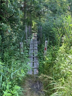
I visited on July 20, 2020 and it was a hot day in the high 80s. The path was grassy, indicating not too many visitors. Beautiful and well-shaded. From the roadway, the trail opens up onto marshes and the water. A variety of blank signs were not helpful. As I got closer to the water, greenhead flies were constantly buzzing me. So I could not linger. I'll come back after the summer bugs are gone.
Rating:
Photographs:
Photo Credit: Kent Dillon
Photo Credit: Kent Dillon
Photo Credit: Kent Dillon
Beautiful quick walk!
Submitted by: Anonymous; December 25, 2019; 7:35 am
Photographs:
Great find!
Submitted by: Susan; March 19, 2019; 10:19 am
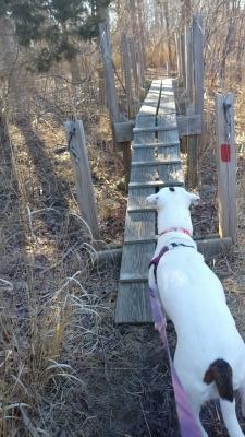
Excellent place to take the dog out for hike! I took my dog here on a whim as I wanted to get her some exercise. I've probably driven by this place many many times, but had no idea it was there. We got at least a mile and a half in. This place has gorgeous views and well-marked trails. My absolute favorite thing about this park is that there's a big sign right when you walk in to let everyone know that all dogs must be on a leash at all times! My dog is not good with other dogs at all, and every time I try to take her to a park it's more anxiety than good for her. I guess most people don't get it unless they have a dog like mine. But this place just makes our hikes so much more enjoyable! I will be back for sure! And I highly recommend it to everyone. I would think it would be a great place for kids to explore as well.
Rating:
Photographs:
Photo Credit: Susan
Photo Credit: Susan