

 Bush Hill Nature Reserve
North Kingstown, Land Conservancy of North Kingstown

![]() 0.5 miles of trail
0.5 miles of trail
Easy
Click on the "Trail Map (PDF)" button to download a PDF of the trail map that you can print and take with you on the trail.
Avenza maps are special, free maps that you can use in the Avenza app on your smart phone. These maps let you see your location on the map as you walk. Download the Avenza App for free in the Apple App Store or on Google Play
Click on the Avenza Trail Map button to "purchase" the free map for this trail from the Avenza map store. If this is your first time, Avenza will ask you to set up an account to check out. However, all Avenza trail maps listed on ExploreRI are free.
In Rhode Island the primary hunting seasons typically run from the second Saturday in September to the last day of February and from the third Saturday in April to the last day in May, however this can vary from year to year and depends on what game is being hunted. During hunting season you should wear at least 200 square inches (a hat OR a vest) of blaze orange. During shotgun deer season, which is typically in December, you should wear at least 500 square inches of blaze orange (a hat AND a vest). For more information see the RI DEM website.
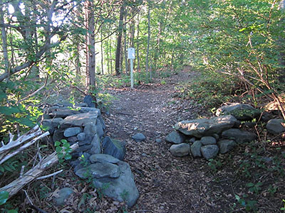
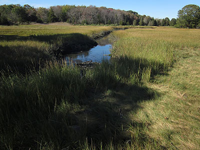
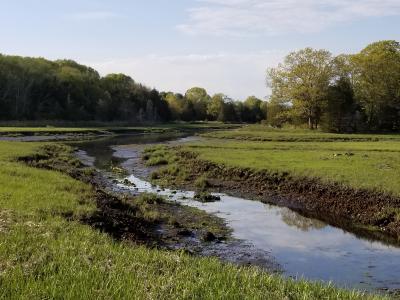


The trail at Bush Hill Nature Reserve is a very easy stroll accessible from Wickford Village. The reserve is a good place for bird watching and there are great views of the salt marsh. The land was once part of the extensive Spink family farm. It was donated to the Land Conservancy of North Kingstown by the de Guzman family in memory of Adelaide Dawson Lynch (1917-1992) who loved Wickford, this land, and its wildlife.
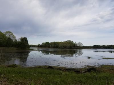
There is an esker (geological feature) that you hike along, looking into Bush Hill Pond. This pond was used as a source of ice and skating in historic times.
Land Conservancy of North Kingstown
Dogs: Yes, Please keep dogs leashed and pick up waste.
This is a Creature Challenge site. The creature is on the Loop Trail.
Learn more about the Creature Challenge.

West Main Street Trailhead
Driving Landmarks: To reach this trailhead from Tower Hill Road/Post Road/Route 1 take West Main Street/Route 1A towards Wickford Village. Go about 1/2 mile and park where you can find a parking spot on West Main Street in downtown Wickford. The public right-of-way access to the trailhead is available down the driveway between 18 West Main St. and 6 West Main St., Wickford (stay to the right on the main driveway).
Parking: Yes: On street, 30 spaces, overnight parking permitted
ADA Accessible Parking Spaces? Yes
Coordinates: 41° 34.331' N 71° 27.149' W See this location in: Google Maps Acme Maps
First Baptist Church Land Trailhead
Driving Landmarks: If coming from the south, head north on Brown Street, then turn right onto Main Street. If coming from the west, continue straight on W Main Street. Turn Left onto Church Lane. Make Left into Church parking lot.
NOTE: This trailhead is on private property owned by the First Baptist Church. However, they are kind enough to allow parking if they are not having events. Please be considerate when using their parking lot. You can also park on Main Street, which is free and open to the public.
Parking: Yes: Parking lot, 20 spaces, no overnight parking
ADA Accessible Parking Spaces? No
Coordinates: 41° 34.367' N 71° 27.07' W See this location in: Google Maps Acme Maps
KEY:
Trailhead
Only trailheads related to this trail system are shown on this map. To see all trailheads go to the main map.
Do you have comments, corrections or additions to the information about this site?
Help us work together to make this website better by sharing your knowledge!


Private feedback goes to the Blueways Alliance/RI Land Trust Council. We'll use your information to make this website better or pass it along to the people who can deal with physical issues at this site. Public comments are posted here (once they've been reviewed and approved) for all to see.
The data on this website come from many sources, including volunteers and organizations across the state of Rhode Island and nearby parts of Massachusetts. We have done our best to make sure the data are accurate and up to date, but any information critical to the success of your trip should be confirmed before you start. The maps and information on this website should not be substituted for topographic maps or other more detailed maps and guides. We welcome corrections and additions. To send a correction or provide other feedback, please use our feedback form (see link above).
This site report was last updated on September 21, 2023
Comments:
Beautiful spot
Submitted by: Anonymous; July 9, 2024; 6:36 pm
Be sure to wear bug spray!
Rating:
Photographs:
Especially lovely in spring
Submitted by: Lisa; May 19, 2021; 7:34 pm
Especially lovely in spring. This is a nice little hike that goes behind WIckford Village and takes you through woods and over wetlands.
Rating:
Photographs:
Photo Credit: Lisa
Photo Credit: Lisa
where is it?
Submitted by: k.s.; November 21, 2019; 8:26 am
you do not give an easy direction for north kingstown residents 15 years here and i don't know where this is? this explanation as to where it is ???? somewhat of a mystery please give me directions if you rec. this email thank you K>S.
Easy Walk for Kids, Bird-watcher & People Who need a little Respite
Submitted by: Anonymous; August 21, 2019; 8:31 am
If you have limited time to get away but need a little peace and quiet - come walk the Bush Hill Preserve - just steps from Wickford Village. It's popular with birders. Fundraising for a footbridge is underway to make it possible to extend the path to Wilson Park and view of the harbor at the DEM boat launch. It is especially beautiful in the autumn. Come. Take a rest from the hectic world nearby.
Rating:
Photographs: