

 Fort Wildlife Refuge
North Smithfield, Audubon Society of Rhode Island

![]() 3.0 miles of trail
3.0 miles of trail
Moderate
Click on the "Trail Map (PDF)" button to download a PDF of the trail map that you can print and take with you on the trail.
Avenza maps are special, free maps that you can use in the Avenza app on your smart phone. These maps let you see your location on the map as you walk. Download the Avenza App for free in the Apple App Store or on Google Play
Click on the Avenza Trail Map button to "purchase" the free map for this trail from the Avenza map store. If this is your first time, Avenza will ask you to set up an account to check out. However, all Avenza trail maps listed on ExploreRI are free.
In Rhode Island the primary hunting seasons typically run from the second Saturday in September to the last day of February and from the third Saturday in April to the last day in May, however this can vary from year to year and depends on what game is being hunted. During hunting season you should wear at least 200 square inches (a hat OR a vest) of blaze orange. During shotgun deer season, which is typically in December, you should wear at least 500 square inches of blaze orange (a hat AND a vest). For more information see the RI DEM website.


The headwaters of the Woonasquatucket River rise on this 235 acre woodland sanctuary of North Smithfield is a great place for a long hike through a variety of northern forest habitats at any time of year. Three small ponds and a variety of deciduous and coniferous trees provide diverse habitat for wildlife.

Trailhead
Driving Landmarks: Take I-295 to Exit 8B (Rte. 7 North). Follow Rte 7 to Providence Pike; bear right onto Providence Pike. Go across at the intersection of Rtes. 5 and 104. The refuge entrance is 1/2 mile ahead on the left, the first left after the Primrose Fire Station.
Parking: Yes: Parking lot, no overnight parking
ADA Accessible Parking Spaces? No
Coordinates: 41° 57.652' N 71° 33.169' W See this location in: Google Maps Acme Maps
KEY:
Trailhead
Only trailheads related to this trail system are shown on this map. To see all trailheads go to the main map.
Do you have comments, corrections or additions to the information about this site?
Help us work together to make this website better by sharing your knowledge!


Private feedback goes to the Blueways Alliance/RI Land Trust Council. We'll use your information to make this website better or pass it along to the people who can deal with physical issues at this site. Public comments are posted here (once they've been reviewed and approved) for all to see.
The data on this website come from many sources, including volunteers and organizations across the state of Rhode Island and nearby parts of Massachusetts. We have done our best to make sure the data are accurate and up to date, but any information critical to the success of your trip should be confirmed before you start. The maps and information on this website should not be substituted for topographic maps or other more detailed maps and guides. We welcome corrections and additions. To send a correction or provide other feedback, please use our feedback form (see link above).
This site report was last updated on April 26, 2021
Comments:
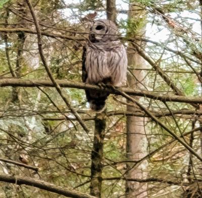
We saw a huge owl.
Submitted by: Beth; November 18, 2020; 6:35 pm
It made my day seeing this majestic owl.
Rating:
Photographs:
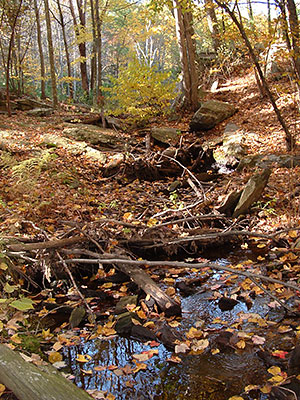
Photo Credit: Beth
4/25/2020
Submitted by: Anonymous; April 25, 2020; 4:57 pm
I have a strong love and great respect of the land and the forest. I have been hiking this trail for a few years now it's my favorite in NRI. However, today it was overcrowded. I found a spot in the parking lot but there were also several cars parked along RTE 5. I had to pick up 8 pieces of trash left by people, there were children running, and broken branches and bark carelessly tossed along the trail, and some beautiful mushrooms I've been watching grow on a tree were knocked to the ground. These are difficult times and people have few options for walking but this is heartbreaking.
Rating:
My hike today at Fort Nature Refuge 4/14/2020
Submitted by: Anonymous; April 14, 2020; 5:27 pm
Wonderfully maintained nature preserve with hiking trails and ponds. This is by far my favorite trail in NRI.
Rating:
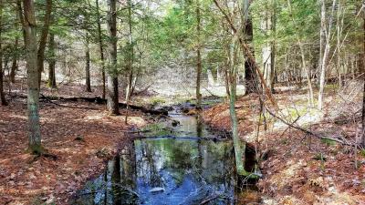
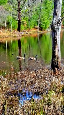
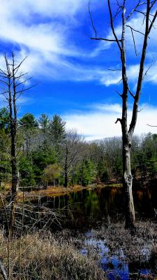
Photographs:
Photo Credit: Judy L.
Photo Credit: Judy L.
Photo Credit: Judy L.