

 Garrison House Acres
South Kingstown, Narrow River Land Trust

![]() 1.0 miles of trail
1.0 miles of trail
Easy
Click on the "Trail Map (PDF)" button to download a PDF of the trail map that you can print and take with you on the trail.
Avenza maps are special, free maps that you can use in the Avenza app on your smart phone. These maps let you see your location on the map as you walk. Download the Avenza App for free in the Apple App Store or on Google Play
Click on the Avenza Trail Map button to "purchase" the free map for this trail from the Avenza map store. If this is your first time, Avenza will ask you to set up an account to check out. However, all Avenza trail maps listed on ExploreRI are free.
In Rhode Island the primary hunting seasons typically run from the second Saturday in September to the last day of February and from the third Saturday in April to the last day in May, however this can vary from year to year and depends on what game is being hunted. During hunting season you should wear at least 200 square inches (a hat OR a vest) of blaze orange. During shotgun deer season, which is typically in December, you should wear at least 500 square inches of blaze orange (a hat AND a vest). For more information see the RI DEM website.
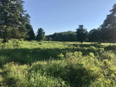


From the roadside trailhead the entrance trail passes through a scrub forest and a stone wall, and then continues into acres of a native grass meadow with views of the Narrow River. On the south side of the meadow the trail enters a wooded area with a small impounded pond that probably was a watering hole for cattle. The property is named for the fortified house destroyed during King Phillips War by the Narragansett Indians in December 1675.
This beautiful 26-acre coastal property is nestled along the Narrow River in South Kingstown. The one-mile walk follows a loop trail through deciduous woodlands, freshwater marshes, open fields and along salt marsh fringing the Narrow River. This property is of particular ecological interest because of its variety of habitats and because it abuts other conserved lands including the 554-acre John H. Chafee National Wildlife Refuge at Pettaquamscutt Cove (managed by US Fish & Wildlife) and land conserved by the Audubon Society of Rhode Island. Together these conservation properties form a contiguous band of wildlife habitat along Pettaquamscutt Cove and the lower Narrow River.
Note: As of late August 2016 the trail was reportedly getting quite overgrown and hard to follow. Long pants are strongly encouraged and be prepared for the trail to be hard to follow.
This is a Creature Challenge site. Learn more about the Creature Challenge.

Middlebridge Road Trailhead
Driving Landmarks: At the western landing of the Middle Bridge crossing the Narrow River.
Parking: Yes: Parking lot, 3 spaces, no overnight parking
ADA Accessible Parking Spaces? No
Coordinates: 41° 27.488' N 71° 27.115' W See this location in: Google Maps Acme Maps
KEY:
Trailhead
Only trailheads related to this trail system are shown on this map. To see all trailheads go to the main map.
Do you have comments, corrections or additions to the information about this site?
Help us work together to make this website better by sharing your knowledge!


Private feedback goes to the Blueways Alliance/RI Land Trust Council. We'll use your information to make this website better or pass it along to the people who can deal with physical issues at this site. Public comments are posted here (once they've been reviewed and approved) for all to see.
The data on this website come from many sources, including volunteers and organizations across the state of Rhode Island and nearby parts of Massachusetts. We have done our best to make sure the data are accurate and up to date, but any information critical to the success of your trip should be confirmed before you start. The maps and information on this website should not be substituted for topographic maps or other more detailed maps and guides. We welcome corrections and additions. To send a correction or provide other feedback, please use our feedback form (see link above).
This site report was last updated on September 18, 2023
Comments:
Great for a winter hike!
Submitted by: Laura; January 10, 2026; 1:56 pm
So glad we tried this one in January despite the reviews. No overgrowth, no bugs, and beautiful views.
Rating:
Photographs:
Photo Credit: Laura
Great time to hike at Garrison
Submitted by: David White; August 28, 2024; 8:20 am
The trails have been mowed in July and August and are in very good shape. The only exception is where the trail goes over the little hill--it enters a very wet area, even now that things have dried out considerably. There is a loop trail around the field and a short trail that bisects the field. There is an amazing array of grasses, ferns and wildflowers. The mosquitos and greenheads are still there, but in very small quantities and are but a minor inconvenience. Recommended: bug spray and decent shoes for areas that might be wet.
Rating:
Needs grooming
Submitted by: Anonymous; August 22, 2024; 9:43 pm
Trail nice but not well maintained. Creature was found, but only because we were lost on trail. Very difficult.
Rating:
Mosquito Haven
Submitted by: Ann W; May 25, 2024; 12:53 pm
We tried to do this walk and couldn't get through the meadow because of the cloud of mosquitoes that followed us, even loaded up with bug spray. The trail was pretty overgrown but still visible so we thought we could manage, but ended up turning back. Hopefully they can mow it to keep bugs at bay, but I'd say skip it for now unless you want to be a meal for the mosquitos.
Rating:
Beautiful hidden secret!
Submitted by: Laura; June 15, 2021; 10:03 pm
What an amazing little gem! The trail had just been mowed and I was able to get through very easily. The reward of seeing the gorgeous meadow at the end was thrilling. Loved the osprey and view of the river and hidden pond too. Only found one tick after I came through but it’s probably loaded in there. Worth it. 💯
Rating:
Photographs:
Photo Credit: Laura
Photo Credit: Laura