

 Ninigret National Wildlife Refuge
Charlestown, U.S. Fish and Wildlife Service

2.8 miles of trail at this site are wheelchair and stroller-friendly, however, these trails may not meet ADA standards.
Hunting is permitted here in season. Wear blaze orange during hunting season. More information
Click on the "Trail Map (PDF)" button to download a PDF of the trail map that you can print and take with you on the trail.
Avenza maps are special, free maps that you can use in the Avenza app on your smart phone. These maps let you see your location on the map as you walk. Download the Avenza App for free in the Apple App Store or on Google Play
Click on the Avenza Trail Map button to "purchase" the free map for this trail from the Avenza map store. If this is your first time, Avenza will ask you to set up an account to check out. However, all Avenza trail maps listed on ExploreRI are free.
In Rhode Island the primary hunting seasons typically run from the second Saturday in September to the last day of February and from the third Saturday in April to the last day in May, however this can vary from year to year and depends on what game is being hunted. During hunting season you should wear at least 200 square inches (a hat OR a vest) of blaze orange. During shotgun deer season, which is typically in December, you should wear at least 500 square inches of blaze orange (a hat AND a vest). For more information see the RI DEM website.


There are two parts to the Ninigret Wildlife Refuge, the Kettle Pond area, north of Route 1 and the Salt Pond area, south of Route 1. The Kettle Pond area abuts the ASRI Kimball Sanctuary and Burlingame State Park.
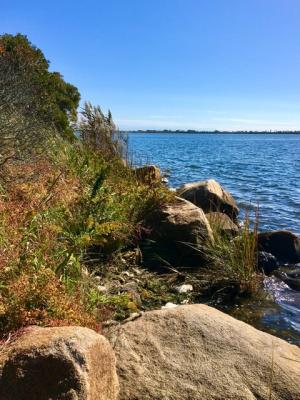
Ninigret National Wildlife Refuge is one of five national wildlife refuges in Rhode Island. Established in 1970, it consists of 858 acres of diverse upland and wetland habitats including grasslands, shrub lands, wooded swamps and freshwater ponds. Formerly part of Charlestown Naval Auxiliary Landing Fields, the refuge now provides visitors with six miles of hiking trails. You may enjoy an excellent view of Ninigret Pond, the largest coastal salt pond in Rhode Island, from the observation platform at Grassy Point. For the birding enthusiasts, over 250 species of birds have been recorded at Ninigret. Also, refuge shores support a large diversity of marine life such as blue crab, bay scallop, and winter flounder.
The parcel of Ninigret National Wildlife Refuge where the Kettle Pond Visitor Center is located is referred to as the headquarters unit. Purchased in 2001, this parcel of forested uplands is home to pitch and white pines, black and white oaks, blueberry shrubs, sweet fern, and princess pine. Hiking along the trails offer visitors a chance to witness visual reminders of the great ice sheet, see changes in the seasonal vernal pool, and views of Watchaug Pond.
Ninigret Wildlife Refuge Website
Dogs: Leashed dogs are allowed at the Kettle Pond Visitor Center trails, except for on the Toupoysett Pond Trail.
Other Amenities: Restrooms are available at the Kettle Pond visitor center and the East Entrance parking lot. At the adjacent Burlingame State Park there are restrooms too, as well as camping, picnic facilities, and a swimming beach.

Kettle Pond Vistor Center Trailhead
Driving Landmarks: If you are coming from the North on U.S. Route 1 South, just follow the signs and the entrance is on your right. If you are coming from the South on U.S. Route 1 North, you will have to double back to travel a short distance heading south on Route 1. The address is 50 Bend Road, Charlestown, RI 02813.
Parking: Yes: Parking lot, 60 spaces, no overnight parking
ADA Accessible Parking Spaces? Yes
Coordinates: 41° 22.066' N 71° 41.111' W See this location in: Google Maps Acme Maps
East Entrance to Salt Pond area Trailhead
Driving Landmarks: If you are coming from the North on U.S. Route 1 South you will have to double back to travel a short distance heading north on Route 1. If you are coming from the South on U.S. Route 1 North, you will veer off of Route 1 onto Old Post Rd. Enter Charlestown's Ninigret Park and drive through the park to get to our parking area, public restrooms and kayak launch site. Follow the road past the tennis courts, playgrounds, Frosty Drew Nature Center, frisbee golf course, stay straight at the turn for the Charlestown Senior Center, go past the new bark park and you will see a brown sign on your right.
Parking: Yes: Parking lot, 34 spaces, no overnight parking
ADA Accessible Parking Spaces? Yes
Coordinates: 41° 21.898' N 71° 39.37' W See this location in: Google Maps Acme Maps
West Entrance to Salt Pond area Trailhead
Driving Landmarks: This will be the second entrance coming from either direction. There will be large brown highway signs to guide you, but from the North you will have to double back at Wildflower Road to travel a short distance heading north on Route 1. This entrance is directly off of Route 1 and is just past a gas station and real estate office on your right.
Parking: Yes: Parking lot, 43 spaces, no overnight parking
ADA Accessible Parking Spaces? Yes
Coordinates: 41° 22.099' N 71° 40.276' W See this location in: Google Maps Acme Maps
KEY:
Trailhead
Only trailheads related to this trail system are shown on this map. To see all trailheads go to the main map.
Do you have comments, corrections or additions to the information about this site?
Help us work together to make this website better by sharing your knowledge!


Private feedback goes to the Blueways Alliance/RI Land Trust Council. We'll use your information to make this website better or pass it along to the people who can deal with physical issues at this site. Public comments are posted here (once they've been reviewed and approved) for all to see.
The data on this website come from many sources, including volunteers and organizations across the state of Rhode Island and nearby parts of Massachusetts. We have done our best to make sure the data are accurate and up to date, but any information critical to the success of your trip should be confirmed before you start. The maps and information on this website should not be substituted for topographic maps or other more detailed maps and guides. We welcome corrections and additions. To send a correction or provide other feedback, please use our feedback form (see link above).
This site report was last updated on February 28, 2019
Comments:
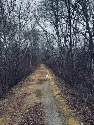
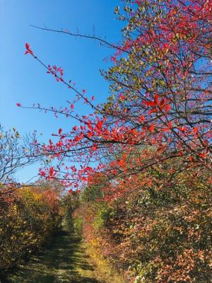
Stunning Trail
Submitted by: Lily; October 18, 2022; 10:17 am
An absolutely beautiful trail, especially this time of year (October), with colors exploding everywhere; amazing variety of trees and gorgeous views, especially of Ninigret Pond. Highly recommended.
Rating:
Photographs:
Photo Credit: Lily
Photo Credit: Lily
Photo Credit: Lily
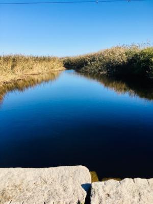
One of my favorites
Submitted by: Anonymous; December 28, 2019; 4:03 pm
Really nice, well marked loop. Flat and easy walk.
Photographs: