

 Handy Pond
Lincoln, Town of Lincoln

![]() 4.0 miles of trail
4.0 miles of trail
Moderate
Click on the "Trail Map (PDF)" button to download a PDF of the trail map that you can print and take with you on the trail.
Avenza maps are special, free maps that you can use in the Avenza app on your smart phone. These maps let you see your location on the map as you walk. Download the Avenza App for free in the Apple App Store or on Google Play
Click on the Avenza Trail Map button to "purchase" the free map for this trail from the Avenza map store. If this is your first time, Avenza will ask you to set up an account to check out. However, all Avenza trail maps listed on ExploreRI are free.
In Rhode Island the primary hunting seasons typically run from the second Saturday in September to the last day of February and from the third Saturday in April to the last day in May, however this can vary from year to year and depends on what game is being hunted. During hunting season you should wear at least 200 square inches (a hat OR a vest) of blaze orange. During shotgun deer season, which is typically in December, you should wear at least 500 square inches of blaze orange (a hat AND a vest). For more information see the RI DEM website.
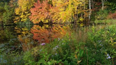


The Handy Pond trails are located on a relatively hidden piece of open space in Lincoln, sandwiched between the villages of Manville and Albion on Old River Road. Locals will know the area for Rochambeau Pond: a popular largemouth bass and trout fishing spot stocked by RI DEM. Beyond the pond, hikers will find miles of cleared trails winding up and down small hills past the pond and feeder streams. Walk to see the old cemetery, stone walls, and cart paths that illustrate the history of the land. Look for the rock outcropping that, after a quick scramble up in winter, will afford views of the high points in nearby Cumberland.
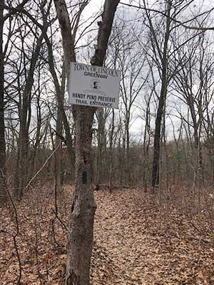
The trails are color coded (see the map), which is helpful to observant hikers, but there is no information about the lengths of the trails. Please respect abutting neighborhoods and private property.
This description is adapted, with permission, from Trails and Walks Rhode Island.
Dogs: Yes, Please keep dogs leashed and pick up waste.
Other Amenities: Fishing for largemouth bass and trout is very popular in Rochambeau Pond. The RI DEM annually stocks the pond with Trout.

Trailhead Across from Crestwood Lane Trailhead
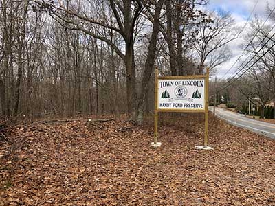
Driving Landmarks: The trailhead is on Old River Road, 150 feet north of Crestwood Lane. There is a small pullout with space for 2-3 cars but more cars can park on the shoulder of Old River Road. Look for a sign that says "Town of Lincoln, Handy Pond Preserve."
Parking: Yes: Parking lot, no overnight parking
Coordinates: 41° 57.244' N 71° 28.144' W See this location in: Google Maps Acme Maps
KEY:
Trailhead
Only trailheads related to this trail system are shown on this map. To see all trailheads go to the main map.
Do you have comments, corrections or additions to the information about this site?
Help us work together to make this website better by sharing your knowledge!


Private feedback goes to the Blueways Alliance/RI Land Trust Council. We'll use your information to make this website better or pass it along to the people who can deal with physical issues at this site. Public comments are posted here (once they've been reviewed and approved) for all to see.
The data on this website come from many sources, including volunteers and organizations across the state of Rhode Island and nearby parts of Massachusetts. We have done our best to make sure the data are accurate and up to date, but any information critical to the success of your trip should be confirmed before you start. The maps and information on this website should not be substituted for topographic maps or other more detailed maps and guides. We welcome corrections and additions. To send a correction or provide other feedback, please use our feedback form (see link above).
This site report was last updated on February 27, 2019
Comments:
Handy pond trail
Submitted by: Teri; June 8, 2020; 2:08 pm
Not very well maintained. Trails ate not clearly marked. Lots of bugs. So sad, it is a nice place.
Rating:
Great place
Submitted by: Luke; April 7, 2020; 6:22 pm
I grew up down the street from these trails hiked them every week and always found something new now that I am older thinking about going back to bring back memories side note wondering if that old beat up car is still buried in the woods guess I’ll have to find out
Rating:
Nice Woods - Map Needs Improvement
Submitted by: Brian Maynard; March 28, 2020; 7:36 pm
I would have given this preserve 5 stars but for the map, which has serious problems. It is very hard to follow - the colors do not always match the blazes - and the trails are poorly marked. How hard is it to get the colors right? The "pink" trail is marked with red, navy blue and sky blue paint - like what? The "green cart" trail is marked with blue? Very confusing. Turns in the trail are not marked at all. We got really lost a few times and luckily met a hiker that directed us back to the trailhead.
Enough complaining - the woods and power lines are wonderful. This is a typical rich woods site with black birch, red oak, black oak. shagbark hickory and more. We were there in late March and hope to come back in May during the spring ephemeral bloom. Lots of nice moss covered rocks too!
It is obvious that there are lots of deer in here - so we will be checking for ticks tonight. Only one more negative - Rt 146 and I-295 are very noisy at the south end of the hike - but only for a bit and not a huge deal. We highly recommend this hike - despite the drawbacks.
Rating:
Handy Pond
Submitted by: Steve; October 13, 2019; 10:09 am
Great place for a short hike.
Rating:
Photographs:
Photo Credit: Steve