


 Blackstone River State Park
41° 56.316' N 71° 26.062' W See this location in: Google Maps Map Server Acme Maps
This is a site for launching hand-carried boats and it is also a portage. This typically means that to continue paddling down the river past this site you will have to portage your boat around a dam or other obstruction.
Description & Overview:

This site is in the heart of the Blackstone River State Park. You can paddle both the canal and the river from here or do a round trip using both. The canal has no current and so is great for beginners, and it also avoids the quickwater on the river and the difficult portage around the Pratt Dam, 2.7 miles downstream. Here are some details on the canal, followed by the river:
CANAL: The canal is best accessed near the dam and the pedestrian bridge, up-river from the viaduct. On the canal you can paddle 2.6 miles south to the Front Street bike path access site or turn around at any point and paddle back to the starting point.
RIVER: The river can be accessed either near the dam (upriver from the viaduct), or down the steps behind the Kelly House Museum. If you are paddling down the river to here from Albion, take out on river right just above the dam and if you want to continue downriver carry down to one of the above put-ins or to the canal. The river is broad and smooth with areas of quickwater below here. In 2.7 miles you will come to the dangerous Pratt Dam where you must take out at river right before the dam and then walk up to the bikeway on top of the dam. From there, if you are continuing downriver, turn left and follow the bikeway until you see a set of steps on your right leading to the river. If taking out, or transferring to the canal to go back up river, carry across the river on the bike path that goes across the top of the dam and continue on to the Front Street parking area. This is about a 1000 foot carry. There is access to the canal near the parking lot.
CAUTION: Do not attempt to paddle through the stone arches of Pratt Dam. Paddling through the arches is not recommended for anyone.
Portions of this description were adapted from the very useful Blackstone Valley National Heritage Corridor guide to the river and the bike path in this area. See link below.
This site provides access to the following water bodies in the Blackstone River watershed: Blackstone River.
Location:
Alternate Site Name: Kelly House, Ashton Dam
Town: Lincoln
Nearest Town Center: Ashton
Driving Landmarks: From route 146 north take the exit for route 116 and go left at the end of the ramp onto route 116 north. From route 146 south take the exit for route 116 north and merge onto route 116 at the end of the ramp. Continue on route 116 north (George Washington Highway) for about 0.7 miles then turn right at the traffic light and then immediately bear left to follow Old River Road (route 126). Go 0.7 miles and turn left onto Cullen Hill Road and then go 0.3 miles to the end of Cullen Hill Road and turn left onto Lower River Road. Go SLOW on this narrow road. Keep going to the end of Old River Road and then turn right across a small bridge and park by the massive concrete abutments for the viaduct that carries route 116 across the river.
You can also get to this site from the other (east) side of the river, at the bike path access, but you will have to carry your boat across the footbridge over the river to get to the launch site and parking can be more problematic on the east side of the river.
Access & Waters:
Water 'Features' At Site: dam, whitewater, flatwater/slow moving river, canal
Note: Because one boat launch can access, say, both a lake and a river or both the upstream and downstream portions of a river, not all paddling trips at a given site will necessarily encounter all of the features listed.
Type of Access: Boat launch for hand carried boats
ADA Accessible Boat Launch? no
Shoreline: The shoreline of the river is rocks and gravel. The canal is accessed via steps.
Float/Dock: no
Portage Length: 200 feet
Parking:
Parking: yes: 10 spaces
Sources for More Information:
Other Guidebooks: Paddle 31 in "Paddling Connecticut and Rhode Island"
Ecological, Cultural & Recreational Attractions:
The Captain Wilbur Kelly House Transportation Museum is located at this site. It is the former home of ships captain and mill owner Wilbur Kelley and has been transformed into a museum on transportation in the Blackstone Valley. Open April-October, 7 days a week 9-4:30.
Photographs:
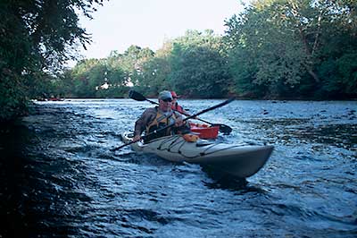
In Quickwater below Blackstone River State Park
Photography by: Bruce Hooke
Date of Photograph: October 3, 2007
Paddlers in quickwater below Ashton/Blackstone River State Park and above Pratt Dam.
Do you have comments, corrections or additions to the information about this site?
Help us work together to make this website better by sharing your knowledge!

Private feedback goes to the Blueways Alliance/RI Land Trust Council. We'll use your information to make this website better or pass it along to the people who can deal with physical issues at this site. Public comments are posted here (once they've been reviewed and approved) for all to see.
The data on this website come from many sources, including volunteers and organizations across the state of Rhode Island and nearby parts of Massachusetts. We have done our best to make sure the data are accurate and up to date, but any information critical to the success of your trip should be confirmed before you start. The maps and information on this website should not be substituted for nautical charts, topographic maps, or other more detailed maps and guides. We welcome corrections and additions. To send a correction or provide other feedback, please use our feedback form (see link above).
This site report was last updated on June 5, 2011