

 Big River at Big River Rd.
41° 38.943' N 71° 36.851' W See this location in: Google Maps Map Server Acme Maps
This is a site for launching hand-carried boats such as canoes or kayaks.
Description & Overview:
NOTE: The road to this site has been closed by RI DEM, apparently permanently, due to problems with illegal dumping. The put-in next to Route 3 is a good alternative.
This site provides access to Big River for hand-carried boats, just downstream from where Big River goes under Interstate 95. Big River flows very slowly so it is possible to paddle against it, making round-trips a viable option. Heading downstream from Big River Road takes you into Reynolds Pond, which in turn leads to Johnson Pond, which is part of Flat River Reservoir. Reynolds Pond is a beautiful winding pond with a mix of white pines and cedar swamps along the shore. The pond is mostly within Big River Management Area is largely undeveloped. You are likely to see some fisherman, but the water is shallow so fast motorboats generally avoid this area. At the far end of Reynolds Pond there is a low bridge over the channel that leads into Johnson Pond. There is a boat ramp on the other side of this bridge at the DEM Zeke's Bridge Fishing Access site. The bridge is low enough to block larger boats but canoes and kayaks can fit under easily at normal water levels.
Heading upstream from Big River Road, you immediately have to go under I-95. The three tunnels the river runs through are about 300 feet long but they are big and straight. Once through these tunnels it is a quarter mile to Route 3, where there is also an access site. Beyond Route 3 you are heading into the heart of the 8600 acre Big River Management Area. Be prepared for lots of twisting and turning because the river follows a very meandering course. At times the main channel can be hard to follow because of the many dead end side channels that branch off. If in doubt at a fork, look for which channel has more current. These challenges, combined with the fact that you are paddling upstream and likely to encounter beaver dams, makes this a much more energetic paddle than Reynolds Pond. The reward is getting to explore a beautiful natural area, but inexperienced paddlers may get frustrated before they get very far. Much of the area is low and marshy but the river occasionally swings close to higher ground, providing some possible picnic sites. If the water level is good and the channel not too overwhelmed by vegetation you can go about 2 3/4 miles beyond Route 3 to where Nooseneck River comes in from the west. Shortly beyond here both Nooseneck River and Big River get too narrow to be paddleable.
This site provides access to the following water bodies in the Pawtuxet River watershed: Big River, Reynolds Pond.
Location:
Town: West Greenwich
Driving Landmarks: Take exit 6 off I-95 in West Greenwich. If you are coming from the north (Warwick), turn left at the end of the ramp; if you coming from the south (Westerly), turn right. This will put you on Route 3 (Nooseneck Hill Road) heading south. Go 1.3 miles and then turn right under the highway onto Weaver Hill Road. Go 1/4 mile and turn right onto Big River Road. This road is 3/4 mile long and mostly dirt. It's somewhat rough but it is drivable by regular cars under normal conditions. When you come to a fork, stay right. The river and parking area are just ahead.
Access & Waters:
Water 'Features' At Site: flatwater/slow moving river, pond
Note: Because one boat launch can access, say, both a lake and a river or both the upstream and downstream portions of a river, not all paddling trips at a given site will necessarily encounter all of the features listed.
Type of Access: Boat launch for hand carried boats
ADA Accessible Boat Launch? no
Shoreline: There are a couple of possible launching spots adjacent to the parking lot. Both are a bit rocky but quite functional. The rocks are there to prevent erosion.
Float/Dock: no
Approximate Length of Carry between Car Access and Water: 20 feet
Hours of Operation: Closed from 1/2 hr. after sunset to 5 am, except for fishing and boating
Parking:
Parking: yes: 10 spaces
ADA Accessible Parking Spaces? no
Sources for More Information:
AMC River Guide: 4th Edition, page 146
AMC Quiet Water Canoe Guide: 2nd Edition, page 190
Photographs:
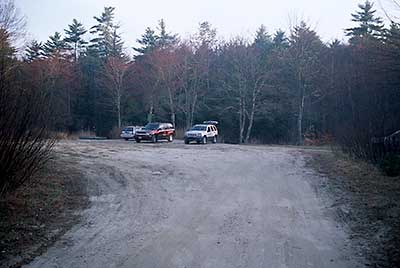
The Parking Area at the end of Big River Road
Photography by: Bruce G. Hooke
Date of Photograph: April 20, 2008
This is the parking area next to the Big River at the end of Big River Road.
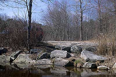
One of the Launch Sites at Big River Road
Photography by: Bruce G. Hooke
Date of Photograph: April 20, 2008
This is one of the place so to launch from at the Big River Road access site.
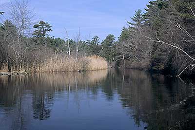
View Down Big River Towards Reynolds Pond
Photography by: Bruce G. Hooke
Date of Photograph: April 20, 2008
This is a view down the Big River towards Reynolds Pond from the access site at Big River Road.
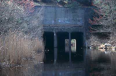
Tunnels Under I-95
Photography by: Bruce G. Hooke
Date of Photograph: April 20, 2008
This is a view of the tunnels under I-95. The tunnels are bigger than the look to be in this photograph. Each tunnel is around 18 feet high and 12 feet wide.
Do you have comments, corrections or additions to the information about this site?
Help us work together to make this website better by sharing your knowledge!


Private feedback goes to the Blueways Alliance/RI Land Trust Council. We'll use your information to make this website better or pass it along to the people who can deal with physical issues at this site. Public comments are posted here (once they've been reviewed and approved) for all to see.
The data on this website come from many sources, including volunteers and organizations across the state of Rhode Island and nearby parts of Massachusetts. We have done our best to make sure the data are accurate and up to date, but any information critical to the success of your trip should be confirmed before you start. The maps and information on this website should not be substituted for nautical charts, topographic maps, or other more detailed maps and guides. We welcome corrections and additions. To send a correction or provide other feedback, please use our feedback form (see link above).
This site report was last updated on August 30, 2010
Comments:
cant fish here anymore
Submitted by: Anonymous; November 16, 2023; 10:46 pm
I used to love fishing herre but the last few years I have not had access to this