


 Central Falls Landing
41° 53.932' N 71° 23.391' W See this location in: Google Maps Map Server Acme Maps
This is a site for launching boats from trailers and it is also a portage, which typically means that to continue paddling down the river past this site you will have to portage your boat around a dam or other obstruction. Boat ramps can normally be used to launch canoes and kayaks but please do your best to keep the boat ramp clear for boat trailers.
Description & Overview:
This site provides access to the Blackstone River and Valley Falls Pond, an extensive area of wetlands with various side channels to explore. There is a new concrete boat ramp. In the summer the Blackstone Valley Explorer tour boat and Samuel Slater Canal Boat tie up here. The Explorer runs public tours of the Blackstone River and Valley Falls Pond. The Samuel Slater can be booked as place to stay with the option to purchase a cruise on the river.
After years of construction the work here finally appears to be done. There's a new restaurant and a paved parking lot. However, the docks where the two tour boats are tied up are only open to passengers/guests on the boats. Fishing is not allowed from either dock.
Kayaks can be rented here. As of September 2022 rentals are available 7 days a week from early June to early October but it would be wise to call ahead to confirm. The number as of 2022 is 401-724-2200.
To paddle to Valley Falls Pond head west (left) from the ramp. In about 1,000 feet various side channels will start branching off, providing many options for exploring.
If you have paddled downriver to this site and you want to continue downriver from here you will have to portage around the dam, which is a long portage. Take out at the ramp on river right and carry across the bridge and then turn right into Valley Falls Heritage Park. Work your way down the ramps and walkways, across a deep tail race channel and towards the river. At first when you get to the river you will be looking down a high stone wall at the water, but if you follow along the river, passing under the railroad bridge, you will get to an area where the stone walls give way to a natural riverbank suitable for launching canoes and kayaks. Heading downstream from here takes you into the heart of Central Falls and Pawtucket. The river below the dam is quickwater, but flattens out quickly. In about a mile you will come to another dam that must be portaged on the left. Another 3/4 mile brings you to Slater Mill in downtown Pawtucket where you must take out before the final dams. The best access is a break in the wall on river right just before Slater Mill. This is the end of the Blackstone River. Below the dam it becomes the tidal Seekonk River, but the first access point is 1/2 mile below the dam.
This site provides access to the following water bodies in the Blackstone River watershed: Blackstone River.
Location:
Town: Central Falls
Driving Landmarks: The landing is located on the corner of Broad St. and Madeira Ave. The entrance to the parking lot is off of Madeira Ave.
Access & Waters:
Water 'Features' At Site: dam, flatwater/slow moving river, pond
Note: Because one boat launch can access, say, both a lake and a river or both the upstream and downstream portions of a river, not all paddling trips at a given site will necessarily encounter all of the features listed.
Type of Access: Boat ramp, portage
ADA Accessible Boat Launch? no
Shoreline: Hard surface ramp
Float/Dock: low float or dock
Approximate Length of Carry between Car Access and Water: 50 feet
Portage Length: 1900 feet
Hours of Operation: 5am to 9pm
Parking:
Parking: yes: 45 spaces, no overnight parking
ADA Accessible Parking Spaces? no
Sources for More Information:
Other Guidebooks: Paddle 31 in "Paddling Connecticut and Rhode Island"
Photographs:
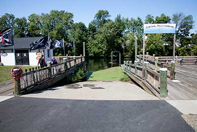
The Boat Ramp
Photography by: Bruce Hooke
Date of Photograph: September 15, 2022
The boat ramp and docks. The green area at the end of the ramp is algae.
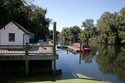
A View Upriver
Photography by: Bruce Hooke
Date of Photograph: September 15, 2022
A view upriver from the docks, with the ramp area in the foreground and the Samuel Slater Canal Boat beyond.
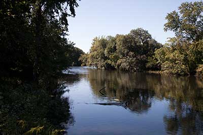
The River
Photography by: Bruce Hooke
Date of Photograph: September 15, 2022
The Blackstone River
Do you have comments, corrections or additions to the information about this site?
Help us work together to make this website better by sharing your knowledge!


Private feedback goes to the Blueways Alliance/RI Land Trust Council. We'll use your information to make this website better or pass it along to the people who can deal with physical issues at this site. Public comments are posted here (once they've been reviewed and approved) for all to see.
The data on this website come from many sources, including volunteers and organizations across the state of Rhode Island and nearby parts of Massachusetts. We have done our best to make sure the data are accurate and up to date, but any information critical to the success of your trip should be confirmed before you start. The maps and information on this website should not be substituted for nautical charts, topographic maps, or other more detailed maps and guides. We welcome corrections and additions. To send a correction or provide other feedback, please use our feedback form (see link above).
This site report was last updated on September 21, 2022
Comments:
Pubic or private?
Submitted by: Ann Durant ; October 2, 2024; 4:22 pm
Lovely flat water paddle! I have avoided this launch because it is unclear as to it being public or private. There is a kayak rental here so we chose to go once they were closed for the season so we are still not sure if we were allowed to park and launch. There is no signage so we decided to go. It would be great to know how this works during the summer season because it is so pretty and close by us!
Oh and the skeleton crew seen in the photo was there for a special event.
[Moderator's Comment: The ramp is open to the public and last we checked the parking was open to the public too, but make sure to look for any new signage. You can also ask the kayak rental people for the latest information as they should be up to date on the current rules.]
Rating:
Photographs:
Photo Credit: Ann Durant
Photo Credit: Ann Durant
Photo Credit: Ann Durant
Fishing
Submitted by: Mel; September 9, 2022; 4:19 am
We have brought out boat here for years. Now the restaurants have the access for what? High cost boat rides. It absolutely horrible that the DEM and the city of Central Falls got away with this. You can't even fish of the docks anymore. They have closed off access to walking trails to fish also. How do you get away with taking this away from the public!! It should be looked into. All we want is equal right for entry for a public waterway!!
Central falls boat ramp
Submitted by: Anonymous; May 7, 2021; 2:37 pm
Nice area to fish. Destroyed for boats. No room to park with a trailer. Fished here for years. Now can't get in. Thanks for shutting down another boat launch on the Blackstone Rhode Island. DEM should be ashamed of treating people like this.
Fishing
Submitted by: Monica; October 2, 2020; 3:58 pm
I think its great they fixed up this place but sadly the people who fish and kayak got truly screwed...We pay for fishing licences boat reg..etc..and can't even fish in my own town I pay taxes in ...yet they have a 20 dollar boat halloween ride you can go on..because the someones making a buck...yet closed to the public..so unfair..closed means closed....otherwise I feel discriminated...Granted they got permission to have this boat stuff..but what about WE who want to fish and enjoy OUR city.
Under construction summer 2020
Submitted by: Anonymous; July 12, 2020; 9:26 pm
As of July 2020 this is closed for construction.