

 Gorton Pond
41° 42.206' N 71° 27.565' W See this location in: Google Maps Map Server Acme Maps
This is a site for launching boats from trailers. Boat ramps can normally be used to launch canoes and kayaks but please do your best to keep the boat ramp clear for boat trailers.
Description & Overview:
Gorton Pond is a 58-acre peaceful oasis in a dense suburban neighborhood. There are houses and buildings all around the pond, except for a small public beach (now overgrown and unusable) at the southeast corner, but most of the houses are at least a bit screened by trees. Gasoline engines are not allowed on the pond so any boats on the pond should be relatively slow moving. About 900 feet east of the boat ramp is an elaborate, handicapped-accessible fishing dock with two roofed gazebos. To get this dock by land go back out to Veterans Memorial Drive and walk east for a few hundred feet and look for the dock on your left at the back of a parking lot. This is also the parking lot for the former beach. The dock is designed for fishing and has a railing all around it so it is not suitable for getting in and out of a boat. The boat ramp is also the better place to launch hand-carried boats.
This site provides access to the following water bodies in the Coastal Watersheds (West Bay) watershed: Gorton Pond.
Location:
Town: Warwick
Nearest Town Center: Apponaug
Driving Landmarks: From I-95 southbound take Exit 10A, which puts you on Route 117 east. From I-95 northbound take Exit 10 and turn right at the end of the ramp onto Route 117 east. Once on Route 117 east go straight for a little over a mile and then go left at the fork, following the signs for Route 1 north. Go another 0.1 miles and go left at another fork, here following the signs for Route 1 SOUTH. This puts you on Veterans Memorial Drive heading west. Go a few hundred feet turn right into the entrance for the Warwick Police Station. Follow the road through the police station parking lot, bearing left in front of the station. The boat ramp is on the right at the back of the parking lot next to the VIN check station. The parking is on the left.
To get back to the highway go back out through the police station lot and turn right onto Veterans Memorial Drive. Go 0.1 mile and stay left at the fork. Go another 0.1 miles and turn right at the light onto Route 117 west. The ramps to I-95 north and south are about 3/4 mile down the road.
Access & Waters:
Water 'Features' At Site: lake/reservior
Note: Because one boat launch can access, say, both a lake and a river or both the upstream and downstream portions of a river, not all paddling trips at a given site will necessarily encounter all of the features listed.
Type of Access: Boat ramp
ADA Accessible Boat Launch? no
Shoreline: A gently sloping asphalt boat ramp leads down to the water line. From there it is a sand and gravel surface leading into the pond.
Float/Dock: no
Parking:
Parking: yes: 50 spaces
ADA Accessible Parking Spaces? no
Nearby Amenities:
Public Restrooms: There is a porta-potty at the fishing dock, a few hundred feet back east on Veterans Memorial Drive. Restrooms may also be available in the police station.
Photographs:
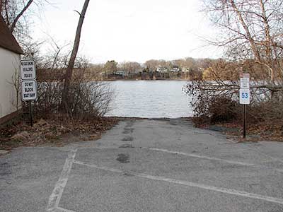
The Boat Ramp at Gorton Pond
Photography by: Bruce Hooke
Date of Photograph: March 10, 2012
The boat ramp at Gorton Pond, with the pond beyond.
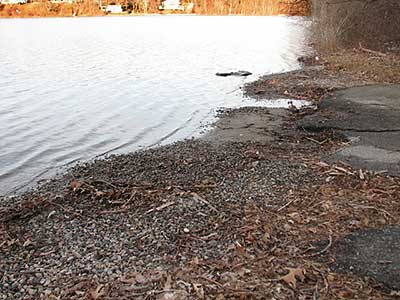
The Lower End of the Boat Ramp
Photography by: Bruce Hooke
Date of Photograph: March 10, 2012
The lower end of the boat ramp, where it deteriorates into sand and gravel.
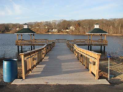
The Fishing Dock
Photography by: Bruce Hooke
Date of Photograph: March 10, 2012
The fishing dock at Gorton Pond, about 900 feet east of the boat ramp, as of 2012.
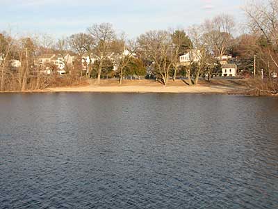
The Beach at Gorton Pond
Photography by: Bruce Hooke
Date of Photograph: March 10, 2012
The former public beach at Gorton Pond, about 1/4 mile east of the boat ramp. As of 2023 the beach is overgrown and unusable.
Do you have comments, corrections or additions to the information about this site?
Help us work together to make this website better by sharing your knowledge!


Private feedback goes to the Blueways Alliance/RI Land Trust Council. We'll use your information to make this website better or pass it along to the people who can deal with physical issues at this site. Public comments are posted here (once they've been reviewed and approved) for all to see.
The data on this website come from many sources, including volunteers and organizations across the state of Rhode Island and nearby parts of Massachusetts. We have done our best to make sure the data are accurate and up to date, but any information critical to the success of your trip should be confirmed before you start. The maps and information on this website should not be substituted for nautical charts, topographic maps, or other more detailed maps and guides. We welcome corrections and additions. To send a correction or provide other feedback, please use our feedback form (see link above).
This site report was last updated on May 15, 2023
Comments:
Beware of boat ramp
Submitted by: Anonymous; June 24, 2025; 3:16 pm
Use caution when launching your boat as every time it rains the gravel washes away and there is a very high chance of damaging your boat and/or trailer. City officials are aware of this issue but do not regularly check or fix it. When they do the remedy is to add gravel where it is washed out and this is filling the pond with the gravel. Also parking is no where near 50 spots. The police are leaving junked patrol vehicles by the ramp leaving very few if any parking spots.
Fishing line disposal
Submitted by: Anonymous; August 16, 2023; 8:52 pm
Photographs:
Photo Credit: Friends of Gorton Pond
Beach is closed
Submitted by: Steve C; May 11, 2023; 2:01 pm
The beach area has been closed for at least 15 years. It is overgrown and sadly ugly. Canada geese have made the shoreline a mess, even by the boat ramp. I used to swim my Labs there, but no more. Its kind of gross
That said, there are lots of big bass abd turtles in the pond. If you can launch a amall boat or canoe, its a nice spot in the middle of Warwick.
Rating:
Just sits there rotting away
Submitted by: Tim Keene; December 16, 2021; 2:49 pm
The dock here used to be beautiful,it gave those who were less mobil on there feet a chance to enjoy the sites an fish.I was fortunate enough to be able to take my mother there fishing the last year of her incredibly strong fight against pancreatic cancer . She started with a cane then a walker after that it was a wheel chair an heated blanket plugged into the outlets that were provided. That do k helped my mother an I forget about the rough times of her battle she never passed on a fishin trip.
Rating:
Photographs:
Photo Credit: Tim Keene