

 Westerley Municipal Boat Ramp
41° 22.5' N 71° 49.928' W See this location in: Google Maps Map Server Acme Maps
This is a site for launching boats from trailers. Boat ramps can normally be used to launch canoes and kayaks but please do your best to keep the boat ramp clear for boat trailers.
Description & Overview:

A major rebuild in 2022 and 2023 replaced the old fixed dock with a floating dock and extended the ramp a bit to prevent deep holes from forming at the end of the ramp.
This state-owned boat ramp with a handicapped accessible dock provides access to the Pawcatuck River near where it makes the transition from freshwater river to tidal estuary. So, before going on the water here it is important to know the times of high and low tide, and how this will influence your trip. You can use this boat ramp as a take out after paddling down the lower Pawcatuck or you can explore north from this site a short distance back up the river, or you can head south from this site towards the ocean. Especially if you head south, you are entering waters trafficed by motorboats and sailboats so if you are in a small boat keep an eye out for larger craft that may not see you. On most days the southwest wind fills in across this area in the morning and blows throughout the afternoon, so be prepared for this when planning your trip.
Parking can be a little problematic for paddlers at this site because most of the parking spaces at the ramp are for vehicles with trailers only. There are four spaces that are for vehicles without trailers.
The shoreline adjacent to the boat ramp is near vertical stone walls and rip rap so the ramp is the only viable place to launch canoes and kayaks. Please do your best to keep the ramp clear for trailered boats. Do as much of your preparation as possible away from the ramp and then just use the ramp to get on the water.
There is also public access for hand-carried boats about 250 yards up river, on the other side of the river, at Donahue Park.
The Wood-Pawcatuck River Guide is highly recommended for paddling on the Wood-Pawcatuck river system.
This site provides access to the following water bodies in the Pawcatuck River watershed: Pawcatuck River.
Location:
Alternate Site Name: Main Street Boat Ramp
Town: Westerly
Nearest Town Center: Westerly
Driving Landmarks: This boat launch is on Main Street in Westerly, 1/4 mile south of Broad Street (Route 1). It is across the street from McQuade's Marketplace.
Access & Waters:
Water 'Features' At Site: flatwater/slow moving river, estuary
Note: Because one boat launch can access, say, both a lake and a river or both the upstream and downstream portions of a river, not all paddling trips at a given site will necessarily encounter all of the features listed.
Type of Access: Boat ramp
ADA Accessible Boat Launch? yes
Shoreline: Hard surface boat ramp
Float/Dock: high dock (over 1' above water)
Hours of Operation: Closed from 1/2 hr. after sunset to 5 am, except for fishing and boating
Parking:
Parking: yes: 34 spaces
ADA Accessible Parking Spaces? yes
Nearby Amenities:
Public Restrooms: On the DEM sign at the boat ramp there are directions to two places with public restrooms within walking distance of the boat ramp. One is the police station, which is open 24 hours a day.
Town Center: Westerly
Sources for More Information:
Other Guidebooks: Paddle 29 in "Paddling Connecticut and Rhode Island"
Website: How to order the Wood-Pawcatuck Watershed Association's River Guide
Photographs:
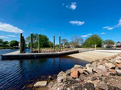
The Rebuilt Boat Ramp and Dock
Photography by: The Nature Conservancy
Photograph Date: May 2023
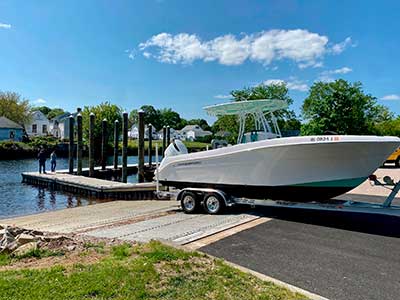
A Boat Being Launched on the Rebuilt Ramp
Photography by: The Nature Conservancy
Photograph Date: May 2023
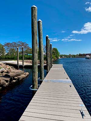
The New Dock
Photography by: The Nature Conservancy
Photograph Date: May 2023
Do you have comments, corrections or additions to the information about this site?
Help us work together to make this website better by sharing your knowledge!

Private feedback goes to the Blueways Alliance/RI Land Trust Council. We'll use your information to make this website better or pass it along to the people who can deal with physical issues at this site. Public comments are posted here (once they've been reviewed and approved) for all to see.
The data on this website come from many sources, including volunteers and organizations across the state of Rhode Island and nearby parts of Massachusetts. We have done our best to make sure the data are accurate and up to date, but any information critical to the success of your trip should be confirmed before you start. The maps and information on this website should not be substituted for nautical charts, topographic maps, or other more detailed maps and guides. We welcome corrections and additions. To send a correction or provide other feedback, please use our feedback form (see link above).
This site report was last updated on May 26, 2023