

 Sakonnet Harbor
41° 27.824' N 71° 11.604' W See this location in: Google Maps Map Server Acme Maps
This is a site for launching boats from trailers. Boat ramps can normally be used to launch canoes and kayaks but please do your best to keep the boat ramp clear for boat trailers.
Description & Overview:

A little care is needed with parking at this site. The official parking area for the boat ramp is limited to vehicles with trailers and other public parking that is not limited to town residents can be hard to find.
There are two cement plank boat ramps here that provide access to Sakonnet Harbor, the Sakonnet River, and Rhode Island Sound. This boat launch provides great access to the pristine shoreline in the area and is the only public boat ramp in Little Compton. The largest eel grass bed in Rhode Island is nearby.
Once outside the small Sakonnet Harbor you are on the open waters of Rhode Island Sound, at the mouth of the broad Sakonnet River, so caution is advised in small craft. Heading north along the shoreline from the harbor, Sakonnet Point provides little protection and the rocky shoreline is "unfriendly" to paddlers, but very pretty. If you head away from shore and out into the middle of the Sakonnet River be prepared for heavy boat traffic as well as large waves and wind. Heading south around Sakonnet Point is only for experienced paddlers because it takes you amongst rocky ledges exposed to swells rolling in from the open ocean. The Sakonnet Point Lighthouse is on one of these ledges. Beyond these ledges, heading east from Sakonnet Point the shoreline is a mix of sandy beaches and rocky headlands.
On most days the southwest wind fills in strongly in this area in the morning and blows briskly throughout the afternoon, producing strong waves, so be prepared for this when planning your trip.
This site provides access to the following water bodies: Sakonnet River, Sakonnet Harbor, Rhode Island Sound.
Location:
Town: Little Compton
Driving Landmarks: Take Route 77 south from Route 138. This will take you through Tiverton Four Corners and past Sakonnet Vineyards (Gray's Ice Cream at the former is a great stop before or after a paddle, save the stop at the vineyards for after the paddle!). 1.8 miles after you pass Sakonnet Vineyards you should see a sign for Sakonnet Point. 3.8 miles from that sign you will come to the parking area for the Haffenreffer Wildlife Refuge. The boat ramp is across the street. (Directions adapted from Ed Mullen's book "Kayaking Narragansett Bay")
Access & Waters:
Water 'Features' At Site: ocean/bay
Note: Because one boat launch can access, say, both a lake and a river or both the upstream and downstream portions of a river, not all paddling trips at a given site will necessarily encounter all of the features listed.
Type of Access: Boat ramp
ADA Accessible Boat Launch? no
Shoreline: Concrete boat ramps, and sand and gravel beach
Float/Dock: no
Hours of Operation: sunrise to sunset, year round
Parking:
Parking: yes: 20 spaces, no overnight parking
ADA Accessible Parking Spaces? no
Nearby Amenities:
Public Restrooms: No
Sources for More Information:
Other Guidebooks: Site 41 in Ed Mullen's book "Kayaking Narragansett Bay"
Photographs:
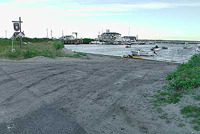
The Boat Ramp and Beach
Photography by: Tom Richardson, New England Boating
Date of Photograph: August 22, 2011
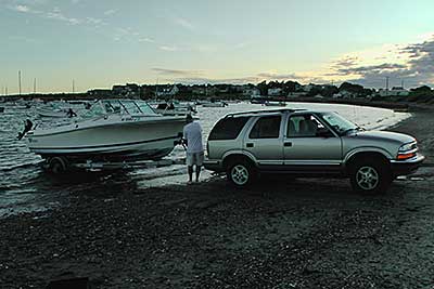
Launching a Boat into Sakonnet Harbor
Photography by: Tom Richardson, New England Boating
Date of Photograph: August 22, 2011
Do you have comments, corrections or additions to the information about this site?
Help us work together to make this website better by sharing your knowledge!

Private feedback goes to the Blueways Alliance/RI Land Trust Council. We'll use your information to make this website better or pass it along to the people who can deal with physical issues at this site. Public comments are posted here (once they've been reviewed and approved) for all to see.
The data on this website come from many sources, including volunteers and organizations across the state of Rhode Island and nearby parts of Massachusetts. We have done our best to make sure the data are accurate and up to date, but any information critical to the success of your trip should be confirmed before you start. The maps and information on this website should not be substituted for nautical charts, topographic maps, or other more detailed maps and guides. We welcome corrections and additions. To send a correction or provide other feedback, please use our feedback form (see link above).
This site report was last updated on May 16, 2022