

 Tarbox Pond
41° 38.184' N 71° 34.408' W See this location in: Google Maps Map Server Acme Maps
This is a site for launching hand-carried boats such as canoes or kayaks.
Description & Overview:

Tarbox Pond is a pretty "meandering" 20 acre pond in Big River Management Area. There are large white pines along the shore and aside from the traffic on Hopkins Hill Road this is a peaceful natural area.
This site provides access to the following water bodies in the Pawtuxet River watershed: Tarbox Pond.
Location:
Town: West Greenwich
Driving Landmarks: Take exit 6A off I-95 in West Greenwich. If you are coming from the north (Warwick), turn left at the end of the ramp; if you coming from the south (Westerly), turn right. This will put you on Hopkins Hill Road heading south. At the stop sign, continue straight across Route 3 on Hopkins Hill Road. Go 1 mile and look for the pond on your left.
Access & Waters:
Water 'Features' At Site: pond
Note: Because one boat launch can access, say, both a lake and a river or both the upstream and downstream portions of a river, not all paddling trips at a given site will necessarily encounter all of the features listed.
Type of Access: Boat launch for hand carried boats
Shoreline: There is a nice sandy spot from which to launch at the corner of the pond and also a gravel are right next to the road that is suitable for launching hand carried boats.
Float/Dock: no
Approximate Length of Carry between Car Access and Water: 15 feet
Parking:
Parking: on street, 8 spaces
ADA Accessible Parking Spaces? no
Photographs:
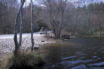
View of the shoreline at Tarbox Pond
Photography by: Bruce G. Hooke
Date of Photograph: April 20, 2008
This is one of the good places from which to launch a boat at Tarbox Pond.
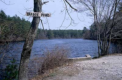
View down Tarbox Pond
Photography by: Bruce G. Hooke
Date of Photograph: April 20, 2008
Do you have comments, corrections or additions to the information about this site?
Help us work together to make this website better by sharing your knowledge!

Private feedback goes to the Blueways Alliance/RI Land Trust Council. We'll use your information to make this website better or pass it along to the people who can deal with physical issues at this site. Public comments are posted here (once they've been reviewed and approved) for all to see.
The data on this website come from many sources, including volunteers and organizations across the state of Rhode Island and nearby parts of Massachusetts. We have done our best to make sure the data are accurate and up to date, but any information critical to the success of your trip should be confirmed before you start. The maps and information on this website should not be substituted for nautical charts, topographic maps, or other more detailed maps and guides. We welcome corrections and additions. To send a correction or provide other feedback, please use our feedback form (see link above).
This site report was last updated on April 24, 2008