


 Oliver Mill Park
41° 54.427' N 70° 54.818' W See this location in: Google Maps Map Server Acme Maps
This is a site for launching hand-carried boats and it is also a portage. This typically means that to continue paddling down the river past this site you will have to portage your boat around a dam or other obstruction.
Description & Overview:

Paddling downriver to Oliver Mill Park, use caution going under the historic Nemasket Street Bridge. There is enough space to fit under the bridge in a canoe or kayak but look before entering the openings under the bridge to make sure there is nothing blocking your way.
Do not attempt to run the fish ladder at Oliver Mill Park! Instead, look for a channel leading off to the right and take out along the grassy bank near the parking lot. If you are planning to continue downriver, or if you are putting in here to start a trip down the Nemasket, carry your boat down past the fish ladder and past where the stone river edging ends and put in at the pool below the dam and fish ladder.
After putting into the river you will almost immediately go under Route 44 and then past a sewage treatment plant. After that, the river winds quietly through woods and marshes for 5.5 miles to the Taunton River. As of June 2011 there were reportedly two large trees down across the Nemasket that force a portage or "lift-over." The first is not far below Oliver Mill Park, the second is below the Murdoch Street Bridge. The first one may be passable at high water. The second is not.
Once on the Taunton it is a mile downriver to the first take out, at Titicut Street. The bridge over the Nemasket at Plymouth Street (1.75 miles below Oliver Mill Park) may have to be portaged, and at very high river levels the bridge at Murdock Street (2.9 miles) will also have to be portaged.
As the Nemasket approaches the Taunton it becomes very winding, in one section taking 1.3 miles along the river to cover 0.3 miles as the crow flies.
The paddle from Oliver Mill Park the Taunton River is a very pretty and quite suitable for less experienced paddlers.
Click here for a printable map and guide (in Adobe Acrobat format) to paddling the Nemasket River above Oliver Mill Park.
This site provides access to the following water bodies in the Taunton River watershed: Nemasket River.
Location:
Town: Middleborough
Nearest Town Center: Middleborough
Driving Landmarks: Take US 44 east from I-495. 2.5 miles down Route 44 from the traffic circle turn right onto Plymouth Street, go about 100 feet and turn right into the parking lot for Oliver Mill Park.
Access & Waters:
Water 'Features' At Site: flatwater/slow moving river
Note: Because one boat launch can access, say, both a lake and a river or both the upstream and downstream portions of a river, not all paddling trips at a given site will necessarily encounter all of the features listed.
Type of Access: Boat launch for hand carried boats
ADA Accessible Boat Launch? no
Shoreline: Grass or sand (depending on river level) both above and below the dam/fish ladder. The sand at the put-in below the dam can be soft if it is underwater, so be prepared to sink in a bit.
Float/Dock: no
Approximate Length of Carry between Car Access and Water: 100 feet
Portage Length: 400 feet
Parking:
Parking: yes: 50 spaces
ADA Accessible Parking Spaces? no
Nearby Amenities:
Public Restrooms: No
Accomodations: There is a KOA Campground just across Route 44 from Oliver Mill Park and reportedly if you call them they will come and pick you up and take you back to the campground but it would be wise to confirm this in advance or just plan to carry your boat and gear the 1/3 mile or so to the campground. For more details see the KOA website.
Sources for More Information:
AMC River Guide: 4th Edition, pages 157-158
Website: Map and Guide to paddling the upper Nemsket River (Adobe Acrobat format)
Ecological, Cultural & Recreational Attractions:
Fishing is not allowed at Oliver Mill Park.
Photographs:
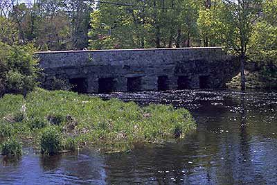
The Historic Nemasket Street Bridge from Oliver Mill Park
Photography by: Bruce G. Hooke
Date of Photograph: May 1, 2010
Looking upriver at the Nemasket Street Bridge which paddlers have to go under the get to the take-out at Oliver Mill Park, in spring when the river was high. The take-out is to the left in this picture, beyond the edge of the picture.
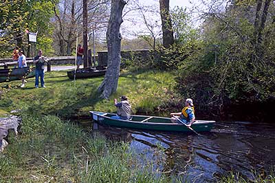
The Take-Out at Oliver Mill Park
Photography by: Bruce G. Hooke
Date of Photograph: May 1, 2010
The historic bridge is to the right and the parking lot is to the left. The fish ladder is behind the photographer. In the summer the wetland plants grow up quite a bit and the channel becomes much narrower, but it is still possible to follow the channel from the river to this take-out.
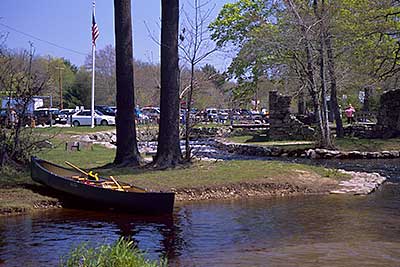
The Put-in at Oliver Mill Park
Photography by: Bruce G. Hooke
Date of Photograph: May 1, 2010
The put-in below the fish ladder and dam at Oliver Mill Park. The park is much busier than usual in this photograph because the annual canoe race was just ending when this photograph was made. The "rapids" in the background in this photograph are the fish ladder, which should not be run in a canoe, kayak or other boat.
Do you have comments, corrections or additions to the information about this site?
Help us work together to make this website better by sharing your knowledge!

Private feedback goes to the Blueways Alliance/RI Land Trust Council. We'll use your information to make this website better or pass it along to the people who can deal with physical issues at this site. Public comments are posted here (once they've been reviewed and approved) for all to see.
The data on this website come from many sources, including volunteers and organizations across the state of Rhode Island and nearby parts of Massachusetts. We have done our best to make sure the data are accurate and up to date, but any information critical to the success of your trip should be confirmed before you start. The maps and information on this website should not be substituted for nautical charts, topographic maps, or other more detailed maps and guides. We welcome corrections and additions. To send a correction or provide other feedback, please use our feedback form (see link above).
This site report was last updated on June 16, 2011