


 East Main Street Bridge
41° 53.772' N 70° 53.865' W See this location in: Google Maps Map Server Acme Maps
This is a site for launching hand-carried boats and it is also a portage. This typically means that to continue paddling down the river past this site you will have to portage your boat around a dam or other obstruction.
Description & Overview:

There is limited parking at this site and East Main Street is fairly busy so this is not the best place to start or end a trip on the Nemasket, but when the river is high the East Main Street Bridge must be portaged because it is too low to fit under in a canoe or kayak. The take out for this portage can be tricky because when the river is high it is moving fairly quickly above the bridge and the take out is just before the bridge on the left, near the small brick structure. Once off the river, carry across the bridge and the street.
The put-in below the East Main Street Bridge is down the road embankment into the "pool" below the bridge, on the right side of the river (facing downriver). This bank is somewhat steep but not that high. When the river is lower, most of this "pool" is the lawn of the adjacent house.
Below East Main Street the Nemasket is quiet and slow moving all the way to Oliver Mill Park, which is 1.5 miles downriver from East Main Street. For much of the way the river is lined with wetlands and houses are only rarely visible. There is a power line that cuts across the river a couple of times.
As you approach Oliver Mill Park, you will see the historic Nemasket Street bridge ahead of you, which is built of stone and has multiple narrow openings that carry the river under the road. These openings are wide enough for a canoe or kayak and are not that long, but look before you enter them to make sure there is nothing blocking the way, and use caution when going through these openings.
Below the bridge, do NOT attempt to run the dams or the fish ladder at Oliver Mill Park. Instead, look for a channel leading off to the right where you can take out along the grassy bank to either end your trip or portage around the dam and fish ladder to continue down the Nemasket.
Click here for a printable map and guide (in Adobe Acrobat format) to paddling this part of the Nemasket River.
This site provides access to the following water bodies in the Taunton River watershed: Nemasket River.
Location:
Town: Middleborough
Nearest Town Center: Middleborough Center
Driving Landmarks: From I-495 north or south take the Exit 4 for Route 105, Middleboro Center and Lakeville. If you are coming from the north go left at the end of the ramp. If you are coming from the south go right at the end of the ramp. This will put you on South Main Street (Route 105) heading northeast. Go about 1.3 miles and turn right onto East Main Street (still Route 105). Go another 0.4 miles to where East Main Street crosses the river.
Access & Waters:
Water 'Features' At Site: flatwater/slow moving river
Note: Because one boat launch can access, say, both a lake and a river or both the upstream and downstream portions of a river, not all paddling trips at a given site will necessarily encounter all of the features listed.
Type of Access: Boat launch for hand carried boats
ADA Accessible Boat Launch? no
Shoreline: earth, mud and roots
Float/Dock: no
Approximate Length of Carry between Car Access and Water: 100 feet
Portage Length: 150 feet
Parking:
Parking: on street, 2 spaces, no overnight parking
ADA Accessible Parking Spaces? no
Nearby Amenities:
Public Restrooms: No
Sources for More Information:
AMC River Guide: 4th Edition, page 157
Website: Map and Guide to paddling the upper Nemsket River (Adobe Acrobat format)
Photographs:
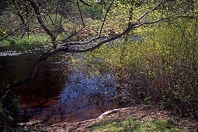
The Take-Out at East Main Street
Photography by: Bruce G. Hooke
Date of Photograph: May 1, 2010
Looking down towards the river at the take-out above the East Main Street Bridge.
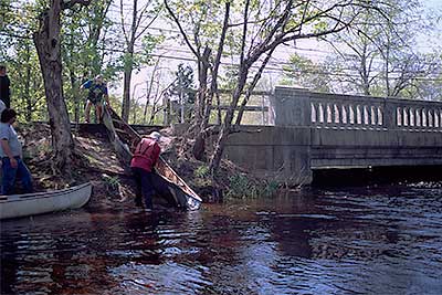
The Put-in below the East Main Street Bridge
Photography by: Bruce G. Hooke
Date of Photograph: May 1, 2010
As this picture shows, the put-in below the East Main Street is short but a bit steep. This photograph also shows why a portage here is necessary when the river is high. At the river level in this photograph there is nowhere near enough space for a canoe or kayak to fit under the bridge. At lower river levels there is space to fit under the bridge and much of the area in the foreground of this photograph is dry ground.

View Downriver from East Main Street
Photography by: Bruce G. Hooke
Date of Photograph: May 1, 2010
The river as seen from the East Main Street Bridge, in spring when the river was high.
Do you have comments, corrections or additions to the information about this site?
Help us work together to make this website better by sharing your knowledge!

Private feedback goes to the Blueways Alliance/RI Land Trust Council. We'll use your information to make this website better or pass it along to the people who can deal with physical issues at this site. Public comments are posted here (once they've been reviewed and approved) for all to see.
The data on this website come from many sources, including volunteers and organizations across the state of Rhode Island and nearby parts of Massachusetts. We have done our best to make sure the data are accurate and up to date, but any information critical to the success of your trip should be confirmed before you start. The maps and information on this website should not be substituted for nautical charts, topographic maps, or other more detailed maps and guides. We welcome corrections and additions. To send a correction or provide other feedback, please use our feedback form (see link above).
This site report was last updated on August 29, 2010