

 South Street East Bridge
41° 53.167' N 71° 1.781' W See this location in: Google Maps Map Server Acme Maps
This is a site for launching hand-carried boats such as canoes or kayaks.
Description & Overview:
NOTE: Plans are being developed to replace the bridge here and at the same time upgrade the river access. The work is tentatively scheduled for 2027. While the work is underway, there will likely be no river access at this site and it is unclear what it will mean for passing under the bridge by boat. Until the work begins, river access may continue to be available here but you should check before assuming that you can access the river at this location.
Paddling downriver to this site, the take-out is on the right just before the bridge.
The path from the parking area down to the river is on the upriver side of the bridge. It is a bit steep and a drop-off partway down to the river adds an extra challenge, but once you get to the river there is usually a small gently sloping area on the riverbank from which to launch canoes and kayaks.
The river below here is broad and slow moving all the way to Taunton (and beyond). It is slow enough that you can also paddle upstream for up to 5 miles before you will encounter rapids too swift to paddle up. One hazard to be aware of is rocks just below the surface of the river. These rocks are usually visible but often hard to see since the river is moving so slowly that the rocks do not create any ripples on the surface of the river. If you hit one at just the right angle it could flip your boat.
Also, the river in this area is tidal so you can expect the river to rise and fall throughout the day. So, when pulling boats up onto the shore, make sure they are far enough up that a rising tide will not float them off and to be safe, tie them to something secure. By the time the river gets to Taunton this rise and fall can approach 4 feet (vertical distance).
The next good take-out below South Street East is 7.4 miles downriver at the boat ramp at Weir Village Park, in downtown Taunton.
The river throughout this entire area is largely tree-lined with only occasional houses, lawns, buildings and pastures visible from the river, until you get into downtown Taunton, where the last mile or so of river before you get to Weir Village Park is more industrial.
This site provides access to the following water bodies in the Taunton River watershed: Taunton River.
Location:
Town: Taunton
Nearest Town Center: Taunton Center
Driving Landmarks: From U.S. 44 just east of MA 24, go south on Orchard Street, which becomes South Street East. Go 1.6 miles and look for a gravel parking area near a small brick building on the left side of the road before the bridge.
Coming from Middleboro Avenue in East Taunton, go north on Old Colony Avenue for 1/4 mile. Go across the bridge and park on the right next to a small brick building.
Access & Waters:
Water 'Features' At Site: flatwater/slow moving river
Note: Because one boat launch can access, say, both a lake and a river or both the upstream and downstream portions of a river, not all paddling trips at a given site will necessarily encounter all of the features listed.
Type of Access: Boat launch for hand carried boats
ADA Accessible Boat Launch? no
Shoreline: Gravel, earth, roots and rocks
Float/Dock: no
Approximate Length of Carry between Car Access and Water: 75 feet
Parking:
Parking: other, 8 spaces, no overnight parking
ADA Accessible Parking Spaces? no
Nearby Amenities:
Public Restrooms: No, but a restroom could probably be found at one of the businesses 1/4 mile south of the put-in on South Street East/Old Colony Avenue, at the junction with Middleboro Avenue.
Sources for More Information:
AMC River Guide: 4th Edition, page 153
Photographs:
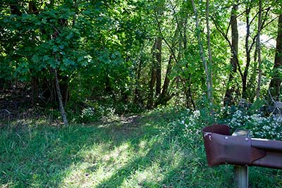
The Path to the Launch Site
Photography by: Bruce Hooke
Date of Photograph: September 15, 2022
The short path to the river is in the center of this photograph.
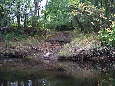
South Street East Boat Launch
Photography by: Jessica Schultz
Date of Photograph: October 4, 2008
View of the path to the river at the South Street East bridge. The bridge is just out of the picture to the left (downriver).
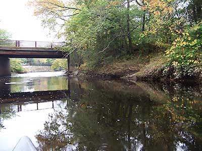
View Downriver at South Street East
Photography by: Jessica Schultz
Date of Photograph: October 4, 2008
A view down the river at the South Street East Bridge. The path to the river is at the grassy area on the right side of the photograph.
Do you have comments, corrections or additions to the information about this site?
Help us work together to make this website better by sharing your knowledge!


Private feedback goes to the Blueways Alliance/RI Land Trust Council. We'll use your information to make this website better or pass it along to the people who can deal with physical issues at this site. Public comments are posted here (once they've been reviewed and approved) for all to see.
The data on this website come from many sources, including volunteers and organizations across the state of Rhode Island and nearby parts of Massachusetts. We have done our best to make sure the data are accurate and up to date, but any information critical to the success of your trip should be confirmed before you start. The maps and information on this website should not be substituted for nautical charts, topographic maps, or other more detailed maps and guides. We welcome corrections and additions. To send a correction or provide other feedback, please use our feedback form (see link above).
This site report was last updated on May 26, 2026
Comments:
Is the South Street East launch still open?
Submitted by: Justin; May 10, 2026; 9:30 am
There is a no trespasssign to the left of the path to the kayak launch. Unsure if it applies to the path or parking lot. Would appreciate some clarification!