


 War Memorial Park
42° 0.974' N 71° 0.581' W See this location in: Google Maps Map Server Acme Maps
This is a site for launching hand-carried boats and it is also a portage. This typically means that to continue paddling down the river past this site you will have to portage your boat around a dam or other obstruction.
Description & Overview:

War Memorial Park provides excellent access to the Town River coming from Lake Nippenicket and Scotland Street. The river is very slow moving throughout this reach so it is quite possible to put in at War Memorial Park and paddle upriver as far as you want to before turning around. Coming downriver, the best take-out at War Memorial Park is on river left (the north side of the river), where the grass comes down to the river.
Paddling downriver below War Memorial Park is more complicated. Do not paddle in the canals that run through the park! Instead, coming from the take-out or the parking areas, cross over the canal and look for a place to put into the river below the stone Ash Street bridge. At low water levels the river here will be very rocky and at high water levels the river may be too fast to be safe. If either case you can by-pass this part of the river by carrying 0.4 miles down to the MA 28 bridge (take River Street to MA 28 and turn right; put in on the downriver side of the bridge on river right). If low water is the problem you can also carry through War Memorial Park to the east end of the park where the canals rejoin the river. Paddling downriver below here at low water will still likely involve a fair amount of dragging your boat over and around rocks, but in a few hundred yards you should reach deeper water. At higher water levels this section will be a bit of exciting quickwater. Be careful going under the MA 28 bridge as there is some low stonework from the old bridge.
The river through West Bridgewater is unfortunately fairly littered with trash, from broken bottles to old tires and metal, but fortunately the littered section is fairly short. Not far below the MA 28 bridge the river enters a broad wetland and once again becomes pretty and slow-moving. It never gets as remote as the section through Hockomock Swamp, but it is still very nice and is much easier paddling then the swamp! You can paddle downriver from War Memorial Park for up to 2.7 miles until the river is blocked by High Street and the dam below High Street. There is no place to take-out at High Street so at that point your only choice is to turn around and paddle back up at least to Reynolds Landing, which is 1.6 miles below War Memorial Park. Since the river is backed up by a dam just below High Street, paddling upriver at least as far as Reynolds Landing should not be a problem. Getting back to War Memorial Park will be harder unless the river is low.
This site provides access to the following water bodies in the Taunton River watershed: Town River.
Location:
Town: West Bridgewater
Nearest Town Center: West Bridgewater
Driving Landmarks: From Route 24 north or south take Exit 16A for MA 106 East - W Bridgewater. This will put you on MA 106 (West Center Street) heading east. Go 2 miles and at the five-way intersection in the center of West Bridgewater, where MA 28 crosses MA 106, turn hard right onto Central Square, go one block, and turn right onto River Street. War Memorial Park is 0.1 miles ahead on the left. There is a gravel parking lot but for access to the river above the dam the better parking is on the turn-out at Arch Street, just beyond the entrance to the gravel parking area. Note that the Arch Street bridge over the river is closed to vehicle traffic.
Access & Waters:
Water 'Features' At Site: dam, whitewater, flatwater/slow moving river
Note: Because one boat launch can access, say, both a lake and a river or both the upstream and downstream portions of a river, not all paddling trips at a given site will necessarily encounter all of the features listed.
Type of Access: Boat launch for hand carried boats
ADA Accessible Boat Launch? no
Shoreline: Mowed grass above the dam, variable conditions but more rocks below the dam.
Float/Dock: no
Approximate Length of Carry between Car Access and Water: 100 feet
Parking:
Parking: yes: 20 spaces
ADA Accessible Parking Spaces? no
Nearby Amenities:
Public Restrooms: No
Sources for More Information:
AMC River Guide: 4th Edition, page 155
Ecological, Cultural & Recreational Attractions:
There are historic mill buildings and related stonework, historic canals, a riverfront park, and walking trails in and near War Memorial Park.
Photographs:
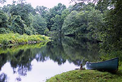
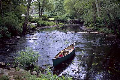
View Upriver from the Take-Out at War Memorial Park
Photography by: Bruce G. Hooke
Date of Photograph: July 15, 2010
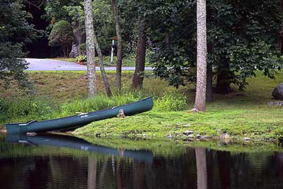
The Take-Out at War Memorial Park
Photography by: Bruce G. Hooke
Date of Photograph: July 15, 2010
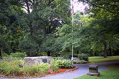
The Main Entrance to War Memorial Park
Photography by: Bruce G. Hooke
Date of Photograph: July 15, 2010
The river is down the grassy slope in the background in this photograph, on the other side of a canal that is just out of the frame of this photograph on the right and left.
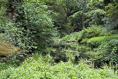
The River Below the Stone Bridge
Photography by: Bruce G. Hooke
Date of Photograph: July 15, 2010
In the middle of July, this is what the river looks like just below the stone bridge at War Memorial Park. Paddling is clearly not an option at this water level! In the spring there is more water here and paddling is an option at least some of the time.
Looking Downriver at the East End of War Memorial Park
Photography by: Bruce G. Hooke
Date of Photograph: July 15, 2010
This is what the river looks like in mid-July at the east end of War Memorial Park. The canal is coming in from the left and the river is coming in from the right. At this water level paddling is not viable for at least a few hundred yards below the park and possibly further, depending on the river level.
Do you have comments, corrections or additions to the information about this site?
Help us work together to make this website better by sharing your knowledge!

Private feedback goes to the Blueways Alliance/RI Land Trust Council. We'll use your information to make this website better or pass it along to the people who can deal with physical issues at this site. Public comments are posted here (once they've been reviewed and approved) for all to see.
The data on this website come from many sources, including volunteers and organizations across the state of Rhode Island and nearby parts of Massachusetts. We have done our best to make sure the data are accurate and up to date, but any information critical to the success of your trip should be confirmed before you start. The maps and information on this website should not be substituted for nautical charts, topographic maps, or other more detailed maps and guides. We welcome corrections and additions. To send a correction or provide other feedback, please use our feedback form (see link above).
This site report was last updated on August 2, 2010