

 Riverlin Street, Millbury
42° 11.576' N 71° 45.122' W See this location in: Google Maps Map Server Acme Maps
This is a site for launching hand-carried boats such as canoes or kayaks.
Description & Overview:

This unofficial put-in is the first access to the river below the Millbury Rapids. From the dirt pullout described in the directions below the river is easily visible next to the street and there are various options for getting to the river. Pick the place that looks best, and least clogged with poison ivy.
The river below here is largely slow moving but there is some quickwater below the dam at the power sub-station half a mile down river from the put-in. This dam must be portaged! The riverbanks are largely wooded but there are occasional houses and commercial buildings visible from the river. As you approach the Singing Dam area the landscape becomes more rural.
For paddling this section of the Blackstone a more detailed guide is necessary then this website can provide. You should use the AMC River Guide or a similar book and only paddle this section of the river if you are an experienced paddler.
NOTE: There are ongoing issues with pollution in the Blackstone River. Great strides have been made in cleaning up the river relative to where it was a generation or two ago but under some conditions the water may still have a noticeable odor.
This site provides access to the following water bodies in the Blackstone River watershed: Blackstone River.
Location:
Town: Millbury
Nearest Town Center: Millbury, MA
Driving Landmarks: From Route 146 take exit 8 for "West Main Street/Millbury." Follow the signs through the traffic circle(s) for "Millbury Ctr." This will put you on Elm Street heading east. Follow Elm Street for 0.7 miles, through the center of Millbury. At the CVS turn left onto Canal Street and park in the small dirt pull-off on the right.
Access & Waters:
Water 'Features' At Site: whitewater, flatwater/slow moving river
Note: Because one boat launch can access, say, both a lake and a river or both the upstream and downstream portions of a river, not all paddling trips at a given site will necessarily encounter all of the features listed.
Type of Access: Boat launch for hand carried boats
Shoreline: Steep bank with grassy & dirt shoreline
Float/Dock: no
Approximate Length of Carry between Car Access and Water: 20 feet
Parking:
Parking: on street, 3 spaces
ADA Accessible Parking Spaces? no
Nearby Amenities:
Public Restrooms: There are various shops and businesses in the area so at least during normal business hours it should not be too hard to find a restroom.
Sources for More Information:
AMC River Guide: 4th edition pages 150-151
Photographs:
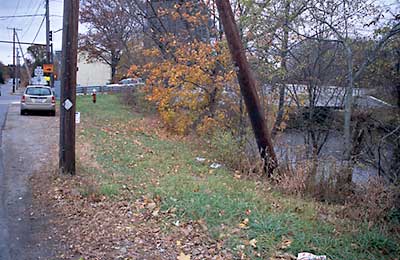
View along Canal Street towards Riverlin Street
Photography by: Bruce Hooke
Date of Photograph: November 3, 2008
Canal Street is to the left in this picture and Riverlin Street is in the background. There are various possible put-ins down the bank on the right.
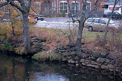
Riverlin Street Put-In
Photography by: Bruce Hooke
Date of Photograph: November 3, 2008
This view, taken from the Riverlin Street Bridge, shows the put-in just above the bridge. This area has, unfortunately, become overgrown with poison ivy since this photograph was made.
Do you have comments, corrections or additions to the information about this site?
Help us work together to make this website better by sharing your knowledge!

Private feedback goes to the Blueways Alliance/RI Land Trust Council. We'll use your information to make this website better or pass it along to the people who can deal with physical issues at this site. Public comments are posted here (once they've been reviewed and approved) for all to see.
The data on this website come from many sources, including volunteers and organizations across the state of Rhode Island and nearby parts of Massachusetts. We have done our best to make sure the data are accurate and up to date, but any information critical to the success of your trip should be confirmed before you start. The maps and information on this website should not be substituted for nautical charts, topographic maps, or other more detailed maps and guides. We welcome corrections and additions. To send a correction or provide other feedback, please use our feedback form (see link above).
This site report was last updated on September 21, 2020