


 Tricentennial Park
42° 10.847' N 71° 43.833' W See this location in: Google Maps Map Server Acme Maps
This is a site for launching hand-carried boats and it is also a portage. This typically means that to continue paddling down the river past this site you will have to portage your boat around a dam or other obstruction.
Description & Overview:

Singing Dam backs the river up for about a 3/8 mile, creating what is effectively a pond that can be paddled in both directions above the dam. Below the dam the river is a mix of flatwater, quickwater and class I-II whitewater. The short sections of class II whitewater can be portaged, but the class I whitewater and quickwater must be run.
The access to the river above the dam is down a short path from the east end of the parking lot but the last part leading down to the river has unfortunately become overgrown with grass and cattails. This takeout will be a bit hard to see from the river if you are paddling down to here from higher up the river but look for it on the right about 50 feet upriver from the dam.
Below the dam and bridge there is a concrete path leading down to the river, to a put-in for paddling downriver. The path starts at the end of the bridge and is about 200 feet long.
Aside from the commercial buildings across the road from the park, the river both above and below here is largely forested, with occasional farm fields, houses and mill buildings visible from the river.
For paddling this section of the Blackstone a more detailed guide is necessary then this website can provide. You should use the AMC River Guide or a similar book and only paddle this section of the river if you are an experienced paddler.
NOTE: There are ongoing issues with pollution in the Blackstone River. Great strides have been made in cleaning up the river relative to where it was a generation or two ago but under some conditions the water may still have a noticeable odor.
This site provides access to the following water bodies in the Blackstone River watershed: Blackstone River.
Location:
Alternate Site Name: Singing Dam
Town: Sutton
Nearest Town Center: Sutton, MA
Driving Landmarks: From Route 122A turn onto Blackstone Street just north of where Route 122A goes under a railroad bridge. There is a sign for J&G Foods at this turn. Go about 0.1 miles down Blackstone Street and park in the parking lot for Tricentennial Park on the left. This park is across the street from J&G Foods and just a little before where the road crosses the river.
Access & Waters:
Water 'Features' At Site: dam, whitewater, flatwater/slow moving river
Note: Because one boat launch can access, say, both a lake and a river or both the upstream and downstream portions of a river, not all paddling trips at a given site will necessarily encounter all of the features listed.
Type of Access: Boat launch for hand carried boats
ADA Accessible Boat Launch? no
Shoreline: Sand and gravel
Float/Dock: no
Approximate Length of Carry between Car Access and Water: 50 feet
Portage Length: 300 feet
Parking:
Parking: yes: 10 spaces
ADA Accessible Parking Spaces? yes
Nearby Amenities:
Public Restrooms: No
Sources for More Information:
AMC River Guide: 4th edition pages 150-151
Ecological, Cultural & Recreational Attractions:
Tricentennial Park is so named because 2004 was the 300th Anniversary of the founding of the town of Sutton. It is a small, 5-acre park with lovely views up the river, picnic tables, and historic markers.
Photographs:
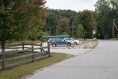
The Parking Lot at Tricentennial Park
Photography by: Bruce Hooke
Date of Photograph: September 18, 2020
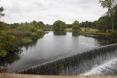
A View Upriver from the Bridge
Photography by: Bruce Hooke
Date of Photograph: September 18, 2020
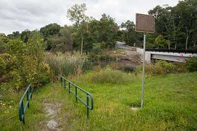
The Overgrown Path to the River above the Dam
Photography by: Bruce Hooke
Date of Photograph: September 18, 2020
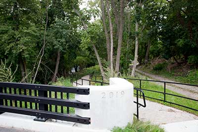
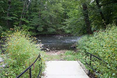
The Start of the Path to the River below the Dam
Photography by: Bruce Hooke
Date of Photograph: September 18, 2020
The Put-In for Paddling Downriver
Photography by: Bruce Hooke
Date of Photograph: September 18, 2020
Note that this image was made in September, during a drought. The river is usually higher than this here.
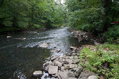
A View Downriver from the Put-in
Photography by: Bruce Hooke
Date of Photograph: September 18, 2020
Note that this image was made in September, during a drought. The river is usually higher than this here.
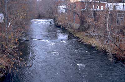
View up River about a Mile Below Singing Dam
Photography by: Bruce Hooke
Date of Photograph: November 3, 2008
This view from the Depot Street bridge in Wilkinsonville shows (in the distance) the broken down dam about a mile below the Singing Dam. At some water levels this broken down dam can be run. At other levels it must be portaged. Stop and scout to determine whether it is runnable. There is no access to the river from the road at Depot Street.
Do you have comments, corrections or additions to the information about this site?
Help us work together to make this website better by sharing your knowledge!

Private feedback goes to the Blueways Alliance/RI Land Trust Council. We'll use your information to make this website better or pass it along to the people who can deal with physical issues at this site. Public comments are posted here (once they've been reviewed and approved) for all to see.
The data on this website come from many sources, including volunteers and organizations across the state of Rhode Island and nearby parts of Massachusetts. We have done our best to make sure the data are accurate and up to date, but any information critical to the success of your trip should be confirmed before you start. The maps and information on this website should not be substituted for nautical charts, topographic maps, or other more detailed maps and guides. We welcome corrections and additions. To send a correction or provide other feedback, please use our feedback form (see link above).
This site report was last updated on September 21, 2020