

 Plummer's Landing
42° 7.733' N 71° 38.207' W See this location in: Google Maps Map Server Acme Maps
This is a site for launching hand-carried boats such as canoes or kayaks.
Description & Overview:

WARNING: As a result of changes in the river's course described below this section of the river should only be paddled by adventurous paddlers willing to deal with many downed trees across the river.
To get to the river walk east through the small park and look for a path leading to the river and to a set of steps down to the water. Watch out for poison ivy along the path and on the river banks.
The river from Plummer's Landing to Rice City Pond has many twists and turns and many sections of quickwater. Strainers (trees in the river) are common as is poison ivy on the banks. The difficulty level of this section of the river increases as the river level rises. The last two miles in Rice City Pond are on flatwater.
1/2 mile below Plummer's Landing you will see rock rip-rap in front of you. At this point the river used to split into two channels. The old canal was the right fork and the original river channel was the left fork. The left fork was recommended because there were many trees down across the old canal. However, at most water levels all the water now flows down the old canal, leaving the old river channel dry. There are still many trees down across the old canal so to continue down the old canal you'll have to find your way over, under or around these trees. When the river is high it may still be possible to paddle down the old river channel.
If you can find your way past all the fallen trees you will get to Rice City Pond where the river opens up into a broad wetland with various side channels. When you approach the stone arch bridge at the south end of the pond take the right arch, which leads under the bridge to a small backwater where there is a good takeout. The left arches, on the other hand, lead to a 6 foot waterfall over the dam!
The river from Plummer's Landing to Rice City Pond runs between forested banks with no houses or other buildings to be seen. As you come into Rice City Pond the shoreline changes to marshland but buildings are still nowhere to be seen.
The Blackstone Valley Heritage Corridor has produced an excellent paddling map of the Blackstone from Plummer's Landing to River Bend Farm. This map (along with other maps for other parts of the river below River Bend Farm) are available for download from the park website (see link below). These maps are highly recommended for paddling this section of the Blackstone River, however, note that map was made before the change in the river's course described above.
NOTE: There are ongoing issues with pollution in the Blackstone River. Great strides have been made in cleaning up the river relative to where it was a generation or two ago but you are still likely to see trash in the river and under some conditions the water may have a noticeable odor.
This site provides access to the following water bodies in the Blackstone River watershed: Blackstone River.
Location:
Alternate Site Name: Chuch Street
Town: Northbridge
Nearest Town Center: Plummer's Corner
Driving Landmarks: From Route 122 take Church Street east for 0.4 miles to Plummer's Landing Park. Look for a blue sign on the right for "Plummer's Landing" and don't be mislead by the small dirt pull-out 100 feet before the main park parking lot. The main lot is a large gravel parking lot with picnic tables beyond it in the woods. There is a sign saying "canoe access" at the side of the parking lot.
Access & Waters:
Water 'Features' At Site: whitewater, flatwater/slow moving river, pond
Note: Because one boat launch can access, say, both a lake and a river or both the upstream and downstream portions of a river, not all paddling trips at a given site will necessarily encounter all of the features listed.
Type of Access: Boat launch for hand carried boats
ADA Accessible Boat Launch? no
Shoreline: sand and a little mud
Float/Dock: no
Approximate Length of Carry between Car Access and Water: 200 feet
Parking:
Parking: yes: 20 spaces
ADA Accessible Parking Spaces? no
Nearby Amenities:
Public Restrooms: There are lots of stores at the corner of Church Street and Route 122, 0.4 miles east of Plummer's Landing, so restrooms should not be hard to find there.
Sources for More Information:
AMC River Guide: 4th Edition, page 151-152
Ecological, Cultural & Recreational Attractions:
Plummer's Landing is a nice little park with picnic tables, nice views of the river, and a walking trail that starts at the back of the parking lot.
Photographs:
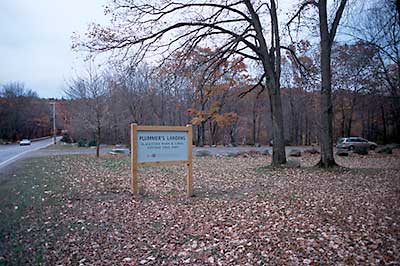
Sign for Plummer's Landing
Photography by: Bruce Hooke
Date of Photograph: November 3, 2008
This view shows the sign for Plummer's Landing, with the parking lot beyond. The river is in the woods on the other side of the parking lot.
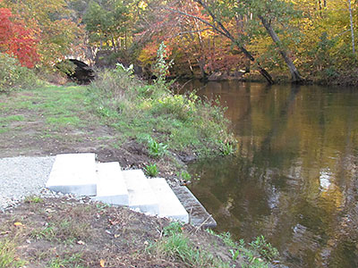
View Upriver from the New Put-In
Photography by: Blackstone River Watershed Association
Date of Photograph: October 14, 2011
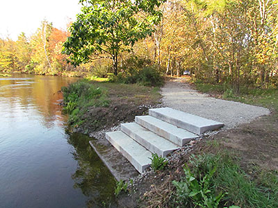
View Downriver from the New Put-In
Photography by: Blackstone River Watershed Association
Date of Photograph: October 14, 2011
Looking downriver from the new put-in at Plummer's Landing. The parking lot is in the background on the right.
Do you have comments, corrections or additions to the information about this site?
Help us work together to make this website better by sharing your knowledge!

Private feedback goes to the Blueways Alliance/RI Land Trust Council. We'll use your information to make this website better or pass it along to the people who can deal with physical issues at this site. Public comments are posted here (once they've been reviewed and approved) for all to see.
The data on this website come from many sources, including volunteers and organizations across the state of Rhode Island and nearby parts of Massachusetts. We have done our best to make sure the data are accurate and up to date, but any information critical to the success of your trip should be confirmed before you start. The maps and information on this website should not be substituted for nautical charts, topographic maps, or other more detailed maps and guides. We welcome corrections and additions. To send a correction or provide other feedback, please use our feedback form (see link above).
This site report was last updated on September 21, 2020