

 Freedom Green
41° 50.001' N 71° 21.577' W See this location in: Google Maps Map Server Acme Maps
This is a site for launching hand-carried boats such as canoes or kayaks.
Description & Overview:
The put in is at the north end of the park -- follow the path past the gazebo to stone steps leading down to the river. This river is an suburban jewel; it provides a wilderness experience right in your back yard. The current is mild and there are no rapids. The river has many twist and turns, and coves to explore. Going upstream is an easy paddle of one and a half miles. In the beginning of the paddle you see a few houses on the right, while the left bank is wooded, hiding a golf course. When you come out to the green grass of the fairways keep an eye out for flying golf balls.
NOTE: As of the middle of June 2026 there is reportedly a large tree down across the river about 1/4 mile downriver from Freedom Green that completely blocks the river making it entirely impassable. If anyone has updated information about this, please let us know so we can spread the word.
The river is dynamic and always changing, blow downs are common. The many twist and turns of the river give you a chance to sneak up on a wide variety of wildlife including large snapping turtles, black crown night heron, blue heron, and deer. Your trip ends at Hunt's Mill. Take out is on the right ("river left") past the island. Here you will find the historic 1750 Hunt House, with well manicured lawn, picnic groves and trails.
Going downstream from the put in at Freedom Green it is a one mile paddle to Omega Pond and Dam. Houses line the right shore of the river and pond, with the left side wooded except for some industrial building near the end of the pond. Freedom Green is the only public access to Omega Pond, but there are plans to provide more public access directly to the pond.
This put-in is on the new Roger Williams Trail that traces the route Roger Williams and his followers took in 1636 when they paddled by canoe from what is now East Providence to Providence, to settle and found what would become the state of Rhode Island.
This site provides access to the following water bodies in the Ten Mile River watershed: Ten Mile River, Omega Pond.
Location:
Town: East Providence
Driving Landmarks: Take 195 east to Exit 6 (Broadway). Turn right at end of ramp onto Warren Avenue. Turn right at first light onto Broadway and go 1.3 miles to the intersection of Roger Williams Avenue/Centre Street and North Broadway. Freedom Green Park is on the right. There is a gazebo in the center of the green. There is a small parking lot for the park off Centre Street.
Or take 195 west to Exit 6 (East Providence). Go right at end of ramp onto Broadway and go 1.4 miles to the intersection of Roger Williams Avenue/Centre Street and North Broadway. Freedom Green Park is on the right. There is a gazebo in the center of the green. There is a small parking lot for the park off Centre Street.
Access & Waters:
Water 'Features' At Site: flatwater/slow moving river, pond
Note: Because one boat launch can access, say, both a lake and a river or both the upstream and downstream portions of a river, not all paddling trips at a given site will necessarily encounter all of the features listed.
Type of Access: Boat launch for hand carried boats
ADA Accessible Boat Launch? no
Shoreline: Stone stairs leading to bare soil shoreline
Float/Dock: no
Approximate Length of Carry between Car Access and Water: 300 feet
Hours of Operation: Sunrise to sunset, year-round
Parking:
Parking: yes: 4 spaces, no overnight parking
ADA Accessible Parking Spaces? yes
Nearby Amenities:
Public Restrooms: None
Town Center: Fire station one half mile north on Broadway
Sources for More Information:
Website: Roger Williams Trail Map (PDF)
Ecological, Cultural & Recreational Attractions:
In 1636 Roger Williams originally settled close by on the shores of Omega Pond, then called Seekonk Cove. This was his first home after being banished from the Massachusetts Bay Colony. The site of his homestead, Roger Williams Spring, is located a half mile from the Park on Roger Williams Avenue. It is marked with a small park and a stone tablet. Later a dam was built to create power and a water supply for the mills that settled around the mouth of the Ten Mile River, where it flows into the Seekonk River.
The up river paddle ends at the 45 acre Hunt's Mill property. The first mill was built here in about 1645. None of the old mill buildings remain except for one stone foundation. Still standing are the John Hunt House built in 1750, a Georgian style center chimney house. The pump house built in 1800's is a stunning stone building. Plans are underway to find a new use for this building.
For more information see the new Roger Williams Trail Map (PDF).
Photographs:
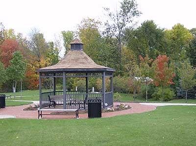
The Gazebo at Freedom Green
Photography by: Keith Gonsalves
This gazebo is in the middle of Freedom Green and makes a good landmark to aim for when you are approaching the site by road. The put-in is behind the trees on the right side of the picture. Follow the trail that goes past the gazebo and it will lead you to the river.
Do you have comments, corrections or additions to the information about this site?
Help us work together to make this website better by sharing your knowledge!


Private feedback goes to the Blueways Alliance/RI Land Trust Council. We'll use your information to make this website better or pass it along to the people who can deal with physical issues at this site. Public comments are posted here (once they've been reviewed and approved) for all to see.
The data on this website come from many sources, including volunteers and organizations across the state of Rhode Island and nearby parts of Massachusetts. We have done our best to make sure the data are accurate and up to date, but any information critical to the success of your trip should be confirmed before you start. The maps and information on this website should not be substituted for nautical charts, topographic maps, or other more detailed maps and guides. We welcome corrections and additions. To send a correction or provide other feedback, please use our feedback form (see link above).
This site report was last updated on June 14, 2026
Comments:
A little Indiana Jones ish
Submitted by: Ann Durant; September 23, 2024; 9:23 pm
We had a perfect weather day. The launch site was a little awkward but once down the stairs it was easy to access off a sandy edge. Unfortunately to the right there were too many downed trees to access the river route. To the left you pass under the road and it’s a nice paddle to Omega Lake. Stay to the left when you get to the old railroad bridge. You will find a small poke through to the lake.
Rating:
Photographs:
Photo Credit: Ann Durant
Photo Credit: Ann Durant
Photo Credit: Ann Durant