

 Woodville Dam Portage
41° 27.578' N 71° 43.144' W See this location in: Google Maps Map Server Acme Maps
This site is a portage. This typically means there either is no road access to this location or that the site is not recommended as a launching site for some other reason. The portage may be around a dam, whitewater, or some other obstruction.
Description & Overview:

While this site can be reached via Woodville Road, the very limited parking options here mean this is better treated as a portage rather than a take-out or put-in. To portage around the Woodville Dam here, take out on river right above the dam where there is a small path that leads up to the road. Carry across the bridge using the sidewalk on the left. The best put it is about 100 feet beyond the end of the bridge.
Below Woodville the river is slow and lazy, with deep water. In 1/2 mile you will come to a fork. Stay left to continue down river or turn right and then stay straight to take an interesting side trip up into the sluiceway for an old mill.
Below here the river flows through woods and wetlands for another 1-1/4 miles and then opens out into Alton Pond, formed by the Alton Dam. It is a 3/4 mile paddle down the pond to the take out and portage at the south end of the pond.
(This description was adapted in part from The Wood-Pawcatuck River Guide, which is highly recommended for paddling on the Wood-Pawcatuck river system.)
This site provides access to the following water bodies in the Pawcatuck River watershed: Wood River.
Location:
Town: Hopkinton
Nearest Town Center: Woodville
Access & Waters:
Water 'Features' At Site: dam, flatwater/slow moving river
Note: Because one boat launch can access, say, both a lake and a river or both the upstream and downstream portions of a river, not all paddling trips at a given site will necessarily encounter all of the features listed.
Type of Access: Portage
Shoreline: The take out is dirt and earth.
Float/Dock: no
Portage Length: 450 feet
Parking:
Parking: no
Nearby Amenities:
Public Restrooms: No
Sources for More Information:
AMC River Guide: 4th Edition, page 138
AMC Quiet Water Canoe Guide: 2nd Edition, page 204
Other Guidebooks: Paddle 24 in "Paddling Connecticut and Rhode Island"
Website: How to order the Wood-Pawcatuck Watershed Association's River Guide
Website: USGS River Gauge on the Wood River below Hope Valley Dam
Photographs:
The Take Out
Photography by: Ed Magilton
Date of Photograph: October 21, 2018
The take-out on river right above the dam.
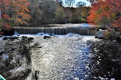
The Dam
Photography by: Ed Magilton
Date of Photograph: October 21, 2018
A view of the dam from the bridge. The take-out is on the left in this image. See the close-up view below for a clearer view of the take-out
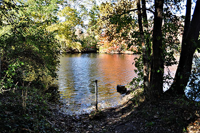
The Take Out
Photography by: Ed Magilton
Date of Photograph: October 21, 2018
The take-out above the dam is in the center of this image.
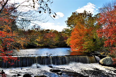
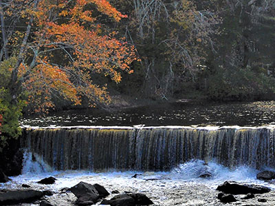
The Dam
Photography by: Ed Magilton
Date of Photograph: October 21, 2018
Lovely fall colors around the dam. Thank you Ed Magilton for sending us these helpful and pretty photographs.
Do you have comments, corrections or additions to the information about this site?
Help us work together to make this website better by sharing your knowledge!

Private feedback goes to the Blueways Alliance/RI Land Trust Council. We'll use your information to make this website better or pass it along to the people who can deal with physical issues at this site. Public comments are posted here (once they've been reviewed and approved) for all to see.
The data on this website come from many sources, including volunteers and organizations across the state of Rhode Island and nearby parts of Massachusetts. We have done our best to make sure the data are accurate and up to date, but any information critical to the success of your trip should be confirmed before you start. The maps and information on this website should not be substituted for nautical charts, topographic maps, or other more detailed maps and guides. We welcome corrections and additions. To send a correction or provide other feedback, please use our feedback form (see link above).
This site report was last updated on October 21, 2018