

 Save the Bay
41° 47.145' N 71° 22.985' W See this location in: Google Maps Map Server Acme Maps
This is a site for launching hand-carried boats such as canoes or kayaks.
Description & Overview:

This public pier, built, owned and maintened by Save the Bay, provides access to the Providence River and Narragansett Bay south of the Port of Providence. It's a bit of a long carry to get your boat down along the gravel paths and out onto the dock but it's not too bad. The ramp to the dock has some bends but you can slide your boat over the railing and onto the dock. Once on the dock there is a very nice wood launching ramp running down into the water.
The major benefit of this launching site is that it gets you south of the port area, where small boats are not very welcome and are at risk from larger boats and industrial activity. Even so, you should be aware that the shipping channel is just east of Fields Point so use great caution if you are crossing to the east shore of the river. While the water you are launching into here is technically the Providence River, it is for practical purposes it is an arm of Narragansett Bay that opens up to mile wide just south of Fields Point. Narragansett Bay proper begins about five miles south of Fields Point, at Conimicut Point. In-between there are various coves to explore by kayak. Pawtuxet Cove and the mouth of the Pawtuxet River are about 1 3/4 miles south of Fields Point.
While the waters here are relatively sheltered the wind can certainly still generate waves large enough to be problematic for kayaks, and the tidal currents can be strong in places, so pay attention the weather, the forecast and the tides.
This site provides access to the following water bodies: Providence River.
Location:
Alternate Site Name: Fields Point
Town: Providence
Nearest Town Center: Providence, RI
Driving Landmarks: From Allens Avenue/Narragansett Blvd in Providence take Harbourside Blvd towards Johnson & Wales. Drive 1/2 mile through the Johnson & Wales campus. Turn right at the sign for Save the Bay. In 1/4 mile you will see a gravel lot on the right. Go past this lot and in another 200 feet, just past a small building and "The Abrams Boathouse," you'll see a public pier on the right, just before road bends left towards the Save the Boat headquarters. You can unload next to The Abrams Boathouse but then you should park in the designated spaces in the Save the Bay parking lot. The spaces are labelled "Public Pier."
Access & Waters:
Water 'Features' At Site: estuary, ocean/bay
Note: Because one boat launch can access, say, both a lake and a river or both the upstream and downstream portions of a river, not all paddling trips at a given site will necessarily encounter all of the features listed.
Type of Access: Boat launch for hand carried boats
ADA Accessible Boat Launch? yes
Shoreline: The water access here is from a low dock. There is not good shoreline access around the dock. But the dock has a very nice wood ramp running down into the water so it is a much better place to launch kayaks than the usual dock. Larger boats are only allowed to "touch and go" dock at the pier.
Float/Dock: low float or dock
Approximate Length of Carry between Car Access and Water: 500 feet
Hours of Operation: Sunrise to Sunset (Closed from Nov. 15 to April 15)
Parking:
Parking: yes: 4 spaces, no overnight parking
ADA Accessible Parking Spaces? yes
Ecological, Cultural & Recreational Attractions:
The gravel parking lot just before you reach Save the Bay provides access to a 0.3 mile trail along the shore, near the Johnson & Wales playing fields. This is a nice walk but not the shoreline access is prohibited along this trail so it is not a place to launch boats.
Photographs:
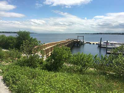
The Public Pier
Photography by: Bruce Hooke
Date of Photograph: June 6, 2019
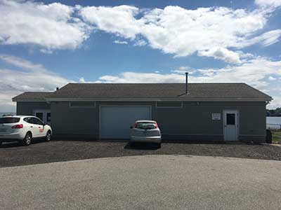
The Abrams Boathouse
Photography by: Bruce Hooke
Date of Photograph: June 6, 2019
The public pier is around to the left in this image.
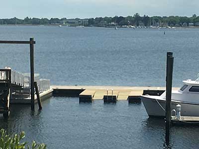
The Float with Lauching Ramps
Photography by: Bruce Hooke
Date of Photograph: June 6, 2019
Do you have comments, corrections or additions to the information about this site?
Help us work together to make this website better by sharing your knowledge!

Private feedback goes to the Blueways Alliance/RI Land Trust Council. We'll use your information to make this website better or pass it along to the people who can deal with physical issues at this site. Public comments are posted here (once they've been reviewed and approved) for all to see.
The data on this website come from many sources, including volunteers and organizations across the state of Rhode Island and nearby parts of Massachusetts. We have done our best to make sure the data are accurate and up to date, but any information critical to the success of your trip should be confirmed before you start. The maps and information on this website should not be substituted for nautical charts, topographic maps, or other more detailed maps and guides. We welcome corrections and additions. To send a correction or provide other feedback, please use our feedback form (see link above).
This site report was last updated on August 3, 2019