

 Seekonk River Small Boat Launch
41° 50.228' N 71° 22.786' W See this location in: Google Maps Map Server Acme Maps
This is a site for launching hand-carried boats such as canoes or kayaks.
Description & Overview:

This canoe and kayak launch, built in 2020, provides access to the Seekonk River at the widest part of the river, where it's half a mile wide and definitely does not feel much like a typical river. Going north (left) you can paddle up to where the river narrows down at the mouth of the Blackstone River. In about 2 1/2 miles you'll come to the I-95 bridge over the river and then the dam at Pawtucket Falls. Going south (right) takes you towards the narrows, where the Seekonk bends around the south end of Providence, past India Point and into Providence Harbor and the Providence River. It's about 1 1/2 miles from the launch site to the start of the narrows. The tide can rung strongly through the narrows and follows an irregular pattern so use caution in the area of the narrows! A strong wind can kick up waves on the Seekonk, so as always, pay attention to the weather.
The driving access to this launch site is a little confusing. Large "Do Not Enter" signs suggest that you should not driving to the parking area but note the smaller "Kayak Launch Parking Only" sign below one of the "Do Not Enter" signs. See the driving directions for more details.
This site provides access to the following water bodies: Seekonk River.
Location:
Town: Providence
Driving Landmarks: Either follow River Drive north along the river through Blackstone Park or following Irving Avenue east off of Blackstone Boulevard to where River Drive and Irving Avenue meet at the edge of the Seekonk River. There's a sharp bend in the road here. At this bend there's a third road that continues north along the river. This road is on the map as Gulf Avenue but there's no sign to indicate this. Gulf Avenue is closed to traffic and there are multiple "Do Not Enter" signs but there's a smaller "Kayak Launch Parking Only" sign and 5 marked parking spaces along the right side of Gulf Avenue.
Access & Waters:
Water 'Features' At Site: estuary
Note: Because one boat launch can access, say, both a lake and a river or both the upstream and downstream portions of a river, not all paddling trips at a given site will necessarily encounter all of the features listed.
Type of Access: Boat launch for hand carried boats
Shoreline: Rubber-surfaced walkway for launching hand carried boats. Adjacent shoreline is rip-rap, brush and trees.
Float/Dock: no
Approximate Length of Carry between Car Access and Water: 20 feet
Hours of Operation: 5am to 9pm
Parking:
Parking: on street, 7 spaces, no overnight parking
ADA Accessible Parking Spaces? yes
Photographs:
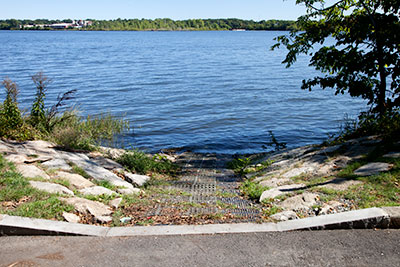
The Launch Site
Photography by: Bruce Hooke
Date of Photograph: September 15, 2022
The walkway to the river.
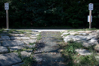
A view up the walkway from the river
Photography by: Bruce Hooke
Date of Photograph: September 15, 2022
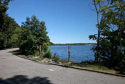
The Launch Site
Photography by: Bruce Hooke
Date of Photograph: September 15, 2022
A view of the launch site with the Seekonk River beyond, looking north from Gulf Avenue.
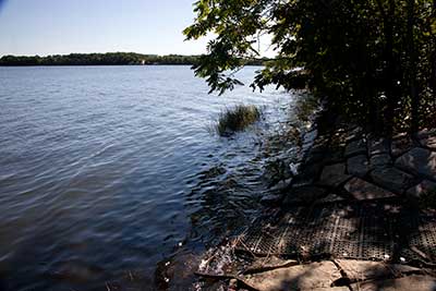
Looking Downriver
Photography by: Bruce Hooke
Date of Photograph: September 15, 2022
A view down the Seekonk, towards the narrows.
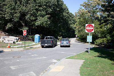
The Access to the Launch
Photography by: Bruce Hooke
Date of Photograph: September 15, 2022
A view up Gulf Avenue towards the launch site, from the junction of River Drive and Irving Avenue.
Do you have comments, corrections or additions to the information about this site?
Help us work together to make this website better by sharing your knowledge!

Private feedback goes to the Blueways Alliance/RI Land Trust Council. We'll use your information to make this website better or pass it along to the people who can deal with physical issues at this site. Public comments are posted here (once they've been reviewed and approved) for all to see.
The data on this website come from many sources, including volunteers and organizations across the state of Rhode Island and nearby parts of Massachusetts. We have done our best to make sure the data are accurate and up to date, but any information critical to the success of your trip should be confirmed before you start. The maps and information on this website should not be substituted for nautical charts, topographic maps, or other more detailed maps and guides. We welcome corrections and additions. To send a correction or provide other feedback, please use our feedback form (see link above).
This site report was last updated on September 21, 2022