

 Georgiaville Pond and Town Beach
41° 53.366' N 71° 30.491' W See this location in: Google Maps Map Server Acme Maps
This is a site for launching boats from trailers. Boat ramps can normally be used to launch canoes and kayaks but please do your best to keep the boat ramp clear for boat trailers.
Description & Overview:
Georgiaville Pond is a medium size pond on the Woonasquatucket River. The town park, at the south end of the pond, has both a boat ramp and the town beach. The historic Smith-Appleby House is at the north end of the pond. There are lots of houses around the pond, but there are also a couple of pretty islands in the pond with tall pine trees on them. The boat launch goes into the pond, but if you paddle from there to the landing near the dam (1/4 mile) you can portage over the dam and into the Woonasquatucket River. For more on this portage and the river below the dam, see the listing for the portage. Note that a town-issued permit is required to park at the town beach and use the boat ramp. You do not have to be a resident of the town to buy a permit.
This site provides access to the following water bodies in the Woonasquatucket River watershed: Georgiaville Pond.
Location:
Town: Smithfield
Nearest Town Center: Smithfield
Driving Landmarks: From Route 104 (Farnum Pike) turn east onto Stillwater Road. The entrance to the town park and beach is 1/4 mile ahead on the left. The boat ramp is on the left, shortly after you turn into the park.
Access & Waters:
Water 'Features' At Site: dam, flatwater/slow moving river, lake/reservior
Note: Because one boat launch can access, say, both a lake and a river or both the upstream and downstream portions of a river, not all paddling trips at a given site will necessarily encounter all of the features listed.
Type of Access: Boat ramp
ADA Accessible Boat Launch? no
Shoreline: There is a paved boat ramp here and the shoreline adjacent to boat ramp is low and grassy.
Float/Dock: no
Fees: To park at or near the town beach you need an annual permit, available at town hall. You do NOT need to be a resident.
Parking:
Parking: yes: 45 spaces
ADA Accessible Parking Spaces? yes
Nearby Amenities:
Public Restrooms: There are public restrooms at the Town Beach but they may not always be open.
Ecological, Cultural & Recreational Attractions:
This site is in the historic neighborhood of Georgiaville, which was built around one of the early mills on the Woonasquatucket. It was built to look like an English mill village because many of the skilled mill workers were English. The boat launch is in a town park, the focus of which is a town beach.
Photographs:
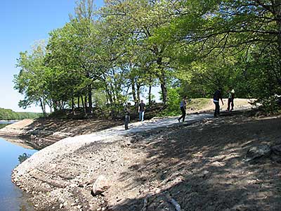
The Boat Ramp, with the Water Lowered
Photography by: Bruce G. Hooke
Date of Photograph: May 21, 2014
This view of the boat ramp when the pond water level had been lowered to allow for work on the dam shows the sudden drop off at the end of the ramp. At normal water levels this drop off should be well underwater but it's something to be aware of.
Do you have comments, corrections or additions to the information about this site?
Help us work together to make this website better by sharing your knowledge!


Private feedback goes to the Blueways Alliance/RI Land Trust Council. We'll use your information to make this website better or pass it along to the people who can deal with physical issues at this site. Public comments are posted here (once they've been reviewed and approved) for all to see.
The data on this website come from many sources, including volunteers and organizations across the state of Rhode Island and nearby parts of Massachusetts. We have done our best to make sure the data are accurate and up to date, but any information critical to the success of your trip should be confirmed before you start. The maps and information on this website should not be substituted for nautical charts, topographic maps, or other more detailed maps and guides. We welcome corrections and additions. To send a correction or provide other feedback, please use our feedback form (see link above).
This site report was last updated on November 2, 2022
Comments:
Dock
Submitted by: Joe; November 2, 2022; 10:34 pm
From which street do you access the boat ramp? Is it from beach only?
[Moderator's Comment: The boat ramp is on the left, shortly after you turn into the park. The entrance to the park is off of Stillwater Road. I have updated the description to address your question.]