

So you want to get out on the water?
We have a variety of resources for you:
 Boat Launch Map: Go here if you want to see a map of boat launches and water trails across the state and the Narragansett Bay Watershed. Note: If you are on dial-up connection, the new map system may be too slow to be useable. The old map system should work better for you but note that the old system does not include most of the sites in Massachusetts and does not include the water trails..
![]() Boat Launch Search: Go here if you are looking for a particular type of boat launch or looking for boat launches on a particular type of water body. For example, you can use this system to find just the salt water boat ramps in a particular town or county.
Boat Launch Search: Go here if you are looking for a particular type of boat launch or looking for boat launches on a particular type of water body. For example, you can use this system to find just the salt water boat ramps in a particular town or county.
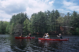
![]() Water Trail Maps: Go here to find online maps and guides to paddling specific rivers, lakes and salt-water routes. Also, for printed maps and books see the Maps & Books page.
Water Trail Maps: Go here to find online maps and guides to paddling specific rivers, lakes and salt-water routes. Also, for printed maps and books see the Maps & Books page.
Research Bouys
If you come across small bouys marked "Research/Do Not Disturb" please do not try to move them or pull them up. These bouys are part of a regular water quality monitoring project by RI DEM on some of Rhode Island's larger rivers, including the Blackstone, Branch, Pawcatuck, Pawtuxet, and Wood Rivers. For more details see this flyer.
Paddling Tips:
- Respect private property adjacent to public waterways.
- Dispose of all trash properly.
- Observe safe paddling techniques and carry necessary safety gear for each outing.
- Leave a "float plan" with family or friends. This float plan form (in PDF format) was created by Sea Kayaker Magazine, which kindly gave us permission to post it here.
- Be aware of current and future weather and water conditions.
- Know your paddling abilities and plan your outings accordingly.
The above tips came from the this website, which also has more a more detailed list of "Canoeing Regulations and Safety Tips."